Southend Central Area Action Plan (SCAAP) Preferred Approach 2015
Appendices
Appendix 1: Southend Core Strategy Policies
|
Core Strategy Policy KP1: Spatial Strategy |
Sets out the spatial strategy for the Borough; the primary focus of regeneration and growth will be the Town Centre and Central Area, including the seafront. |
|
Core Strategy Policy KP2: Development Principles |
Sets out the ways in which new development in the Borough, including transport infrastructure, should contribute to economic, social, physical and environmental regeneration in a sustainable way, and to the regeneration of Southend's primary role within the Thames Gateway as a cultural and intellectual hub and higher education centre of excellence. |
|
Core Strategy Policy KP3: Implementation and Resources |
Makes provision for the preparation of Area Action Plans and Supplementary Planning Documents to help deliver the provisions of the Core Strategy, ensuring that development of an appropriate scale, mix and quality is brought forward in key areas of opportunity and change including the town centre and seafront. |
|
Core Strategy Policy CP1: Employment Generating Development |
Makes provision for an additional 6,500 jobs within the Town Centre and Central Area during the plan period 2001-2021. |
|
Core Strategy Policy CP2: Town Centre and Retail Development |
Promotes the development of the Town Centre, which will remain the first preference for all forms of retail development and other Town Centre uses. The Town Centre is afforded sequential preference for additional comparison and convenience floorspace. |
|
Core Strategy Policy CP3: Transport and Accessibility |
Seeks improvements to transport infrastructure and services by widening travel choice, and providing for high quality transport interchanges at Southend Victoria, Southend Central and Southend Travel Centre. |
|
Core Strategy Policy CP4: The Environment and Urban Renaissance |
Promotes sustainable development of the highest quality and innovation and excellence in design, recognising good quality urban design as a catalyst for regeneration and urban renaissance. |
|
Core Strategy Policy CP5: Minerals and Soils Resources |
Sets out the standards the Borough Council will require regarding the sustainable use of soil and mineral resources. |
|
Core Strategy Policy CP6: Community Infrastructure |
Supports improvements to existing, and the provision of new, facilities to support the needs of education, skills and lifelong learning strategies, including the Town Centre's higher education/university campus. Seeks to safeguard existing and provide for new leisure, cultural, recreation and community facilities. |
|
Core Strategy Policy CP7: Sport, Recreation and Green Space |
Promotes proposals that contribute to sports, recreation and green space facilities within the Borough for the benefit of local residents and visitors. |
|
Core Strategy Policy CP8: Dwelling Provision |
Makes provision for 2,000 net additional dwelling within the Town Centre and Central Area. |
Appendix 2 Glossary of Abbreviations
AA Appropriate Assessment
AAP Area Action Plan
AMR Annual Monitoring Report
AVL Advanced Vehicle Location
BBA Better Bus Area
BID Business Improvement District
c2c Rail Operator of the London Fenchurch Street to Shoeburyness line
CAM Central Area Masterplan
CCG Care Commissioning Group
CCTV Closed Circuit Television
CIRIA Construction Industry Research and Information Association
DCLG Department of Communities &Local Government
DFT Department for Transport
DPD Development Plan Document
EA Environment Agency
ELR Employment Land Review
FRA Flood Risk Assessment
FWMA Floods and Water Management Act 2010
HRA Habitats Regulation Assessment
LDD Local Development Document
LDS Local Development Scheme
LEA Local Economic Assessment
LLFA Lead Local Flood Authority
LPA Local Planning Authority
LSTF Local Sustainable Transport Fund
LTP Local Transport Plan
MSCP Multi Storey Car Park
NHS National Health Service
NPPF National Planning Policy Framework
OAN Objectively Assessed Need
PIP Punctuality Improvement Partnership
PFRA Preliminary Flood Risk Assessment
SAB SUDS Approval Body
SE LEP South East Local Enterprise Partnership
SFRA Strategic Flood Risk Assessment
SHMA Strategic Housing Market Assessment
SWMP Surface Water Management Plan
TGSE Thames Gateway South Essex
Appendix 3 - Schedule of Existing Landmarks and Landmark Buildings
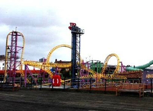 |
Adventure Island, Western Esplanade (Central Seafront Policy Area) |
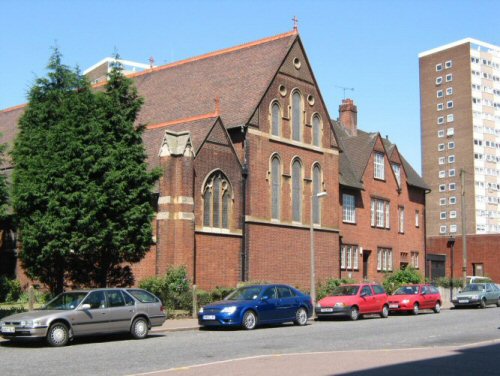 |
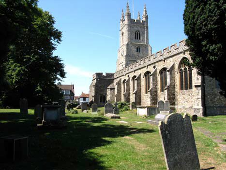
All Saints Church, Sutton Road (outside of the SCAAP boundary) |
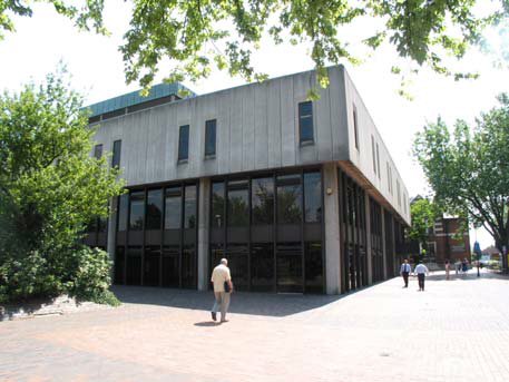 |
Central Library (former), Victoria Avenue (Victoria Gateway Neighbourhood Policy Area) |
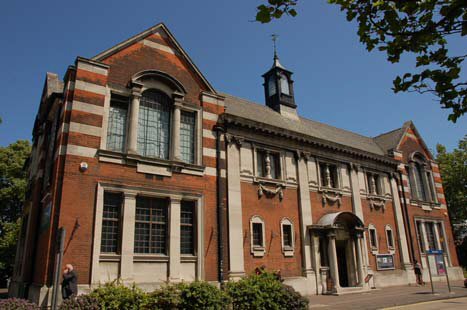 |
Central Museum, Victoria Avenue (Victoria Gateway Neighbourhood Policy Area) |
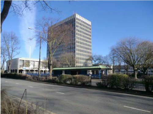 |
Civic Centre, Victoria Avenue (Victoria Gateway Neighbourhood Policy Area) |
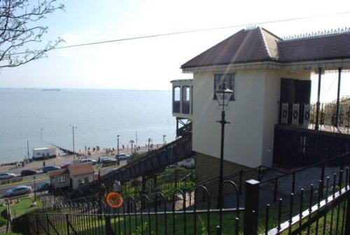 |
Cliff Lift, Western Esplanade (Central Seafront Policy Area) |
 |
Cliffs Pavilion, Station Road (Central Seafront Policy Area) |
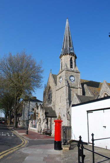 |
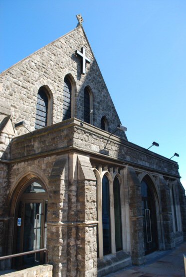
Clifftown Church/Studios, Nelson Street (Clifftown Policy Area)) |
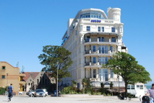 |
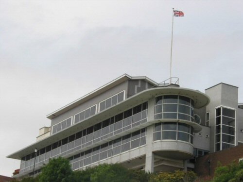
Park Inn Palace Hotel, Pier Hill (Central Seafront Policy Area) |
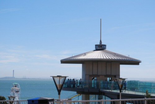 |
Pier Hill Observation Tower and Lift, Pier Hill (Central Seafront Policy Area) |
 |
Porters, Southchurch Road (outside of the SCAAP boundary) |
 |
Prittlewell Chapel, North Road (Victoria Gateway Neighbourhood Policy Area) |
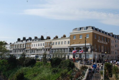 |
Royal Hotel and Royal Terrace (High Street and Clifftown Policy Areas) |
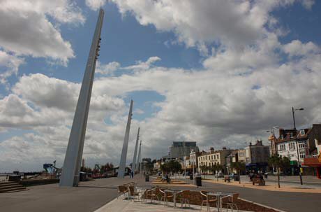 |
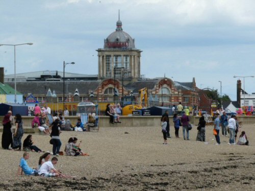
Seafront / Estuary (Central Seafront Policy Area) |
 |
South Essex College, Luker Road (Elmer Square Policy Area) |
 |
St John�s Church, Herbert Grove (Central Seafront Policy Area) |
 |
St Mary�s Church, Victoria Avenue (outside of the SCAAP boundary) |
 |
Swan Hall, Victoria Avenue (Victoria Gateway Neighbourhood Policy Area) |
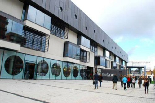 |
The Forum, Elmer Square (Elmer Square Policy Area) |
 |
The Kursaal, Eastern Esplanade (Central Seafront Policy Area) |
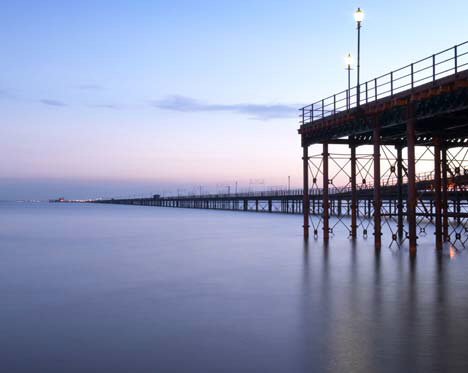 |
The Pier (Central Seafront Policy Area) |
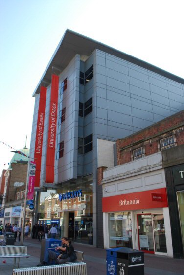 |
University of Essex, Elmer Approach (Elmer Square Policy Area) |
 |
University of Essex, Elmer Approach (Elmer Square Policy Area) |
Appendix 4: Flood Risk Management Technical information and Definitions
Flood Risk Definitions:
Flood risk zone 2 - medium risk, 1 in 1,000 to 1 in 200 annual probability
Flood risk zone 3 - high risk, 1 in 200 annual probability or more
Design flood event and flood level - based on 1 in 200 annual probability event at the end of the development's lifetime.
Extreme flood event and flood level - based on 1 in 1,000 annual probability event at the end of the development's life.
As an example, the SFRA2 predicts that within the Central Seafront Area, outside of Adventure Island, by 2110, the design and extreme maximum flood depth are approximately 1 metre and 4 metres. Adventure Island is characterised by 5m maximum flood depths under both scenarios.
Lifetime of development - assumed to be 100 years for residential, 60 years for commercial (unless circumstances indicate otherwise)
Flood Risk Vulnerability Classification
Highly Vulnerable
- Emergency services
- Emergency dispersal points
- Basement dwellings
More Vulnerable
- Hospitals
- Residential institutions such as care homes, children's homes, and hostels
- Buildings used for: dwelling houses; student halls of residence; drinking establishments; nightclubs; and hotels
- Health services, nurseries and educational establishments
Appendix 5: Transport, Access and Public Realm Strategy
Transport, Access and Public Realm Strategy
In order to secure a 'step change' in Southend Central Area to achieve a modern integrated transport system that unlocks potential in opportunity sites and secures sustainable regeneration and the growth of Southend, transport, access and public realm improvements in Southend Central Area will:
- Work in partnership with the South East Local Enterprise Partnership (SELEP) to deliver investment and improvements to the strategic road network and public realm, highlighting the importance of the A127 strategic corridor to delivering economic growth and housing, as set out in the Southend and Essex A127 Corridor for Growth - An Economic Plan (March 2014) .
- Continue the programme of public realm and access improvements, including a continuation of the Victoria's public realm improvement scheme at London Road, Queensway (west) and Victoria Circus, Queensway (east) (Policy PA4), Victoria Avenue ( Policy PA9), and the Central Seafront Policy Area (including City Beach) (Policy CS1), addressing the principles established by the Southend Streetscape Manual SPD3.
- Continue to develop and support the cycle route network, provision of secure cycle parking and work with Cycle Southend in terms of promotion, marketing, Bikeability and other travel training, and the creation of cycle hubs.
- Seek to pedestrianise a number of the High Street's inter-linking access/stub roads and reduce the dominance of on-street parking and general vehicle circulation, creating one-way streets and 20mph zones.
- Improve the environmental quality of existing residential streets within the Central Area, particularly those to the east of the High Street, to create 'home zones' or pedestrian-priority areas that improve access and encourage walking and cycling.
- Continue to implement a quality signage and way-finding scheme for pedestrians and ensure that variable messaging signs and electronic displays for car parks and travel information better relay details to road and public transport users.
- Encourage the use of sustainable travel modes, ensuring that all forms of transport are equally accessible to all, through smarter choices techniques (including the promotion of a Borough-wide Smart Card ticketing system, and through the use of mobile phone technology) and mobility management measures, promoting opportunity for car sharing and the setting up of car and van clubs.
- Maintain and build upon existing bus stop improvements, real time information and bus prioritisation at signals, as well as targeted junction enhancements and highways improvement works.
- Improve public perceptions of safety within Southend Central Area particularly at night, by ensuring that street lights are maintained, CCTV is obviously sited, and public transport and taxis operate after dark to help secure a vibrant, safe evening economy.
- Work with local bus operators to further improve bus services to the town centre including evening and night time services, providing a more reliable and punctual bus service through the implementation of a Punctuality Improvement Partnership (PiP), and improvements to the Advanced Vehicle Local (AVL) system.
- Work with train operators to achieve high levels of reliability and performance on all services, maintain and promote contra-flow inter-peak services for journeys to Southend, continue active participation in the development and marketing of Station Travel Plans.
- Work with taxi operators to improve the provision for taxi's at key locations to support access.
- Work with stakeholders to develop the work of the Ideas in Motion brand to encourage businesses, schools and colleges to implement managed travel plans and introduce a personalised travel planning service, and to support applications for funding.
- Seek to develop a priority route towards London Southend Airport, together with corresponding junction improvements at A127 Victoria Avenue/Fairfax Drive/East Street linked to future redevelopment of the Roots Hall site.
- Keep car parking demand and capacity under review, recognising that there has been a temporary increase in public car parking in the town centre, seeking to maintain capacity at a level that supports the vitality and viability of the town centre, whilst enabling the delivery of relevant opportunity sites.
- Improve access to car parks for vehicles and pedestrians.
- Encourage an extension to the existing VMS scheme to improve information about car parking capacity within town centre car parks, direct drivers to the most convenient car park, and avoid unnecessary circulating traffic by improving access to town centre car parks from Queensway dual carriage way.
- Ensure that servicing and delivery arrangements meet the reasonable needs of businesses, and minimise their environmental impact; working with the freight industry and logistic to implement more efficient use of vehicles in terms of guidance, zoning and delivery timetables.
Appendix 6 - Dwelling Figures for the Central Area - relationship with Core Strategy Requirements
|
Core Strategy 2001 to 2021 |
Completed April 2001 to March 2014 (net) |
Core Strategy (as adjusted 2014 to 2021) |
Site Allocations (net) to be delivered by 2021* |
Other commitments to be delivered by 2021** |
Total New Dwellings |
Difference from Core Strategy (adjusted 2014 to 2021) |
|
|
SCAAP |
2,474 |
954 |
1,520 |
1,772 |
101 |
1,873 |
+353 |
|
Local Authority Area excluding SCAAP |
4,026 |
3,283 |
743 |
To be determined |
586 |
586 |
-157 |
|
All Borough (Total) |
6,500 |
4,237 |
2,263 |
1,772 |
687 |
2,459 |
+196 |
|
* * Part C sets out the Site Allocations expected to be delivered by 2021. In relation to OS4 and OS11 it is assumed that half of OS4 Queensway and just the major planning permissions within OS11 Victoria Avenue will be delivered by 2021 |
|||
|
** Includes planning permissions under 10 units and those determined through prior approval |
|||
Appendix 7 Major Planning Permissions with Potential Housing Allocation
|
Site Reference |
Site Name |
Indicative number of Dwellings (Gross) |
Within Policy Area |
Within Opportunity Site |
|
PA1.1 |
Maitland House |
98 |
High Street |
- |
|
PA1.2 |
4 Southchurch Rd |
24 |
High Street |
- |
|
PA5.1 |
18 - 20 Southchurch Rd |
16 |
Warrior Square |
- |
|
CS1.1 |
Esplanade House |
266 |
Central Seafront |
- |
|
PA8.1 |
Heath House And Carby House |
280 |
Victoria Gateway Neighbourhood |
os11 |
|
PA8.2 |
Roots Hall Stadium |
242 |
Victoria Gateway Neighbourhood |
os13 |
|
PA8.3 |
297 Victoria Avenue |
30 |
Victoria Gateway Neighbourhood |
- |
|
PA8.4 |
25 Roots Hall Avenue |
18 |
Victoria Gateway Neighbourhood |
os13 |
|
PA8.5 |
Salisbury Avenue and North Road |
43 |
Victoria Gateway Neighbourhood |
- |
|
PA8.6 |
175 London Road |
27 |
Victoria Gateway Neighbourhood |
- |
|
PA8.7 |
Carnarvon Road |
131 |
Victoria Gateway Neighbourhood |
os11 |
|
PA8.8 |
Victoria House |
40 |
Victoria Gateway Neighbourhood |
os11 |
|
PA9.1 |
Kenway |
45 |
Sutton Gateway Neighbourhood |
- |
|
PA9.2 |
257 - 285 Sutton Road |
97 |
Sutton Gateway Neighbourhood |
os14 |
|
PA9.3 |
319 - 321 Sutton Road |
32 |
Sutton Gateway Neighbourhood |
os14 |
Appendix 8: Replaced Saved Planning Policies [7]
Saved Planning Policies replaced by Southend Central Area Action Plan upon adoption
|
Policy/ Proposal Ref. |
Policy Subject |
|
L2 |
Central Seafront Area |
|
L3 |
Southend Pier |
|
C7 |
Shop and Commercial Frontages and Fascias |
|
S5 |
Non-Retail Uses |
|
S8 |
Improvements to Primary Shopping Frontages |
|
S9 |
Retention of Secondary Shopping Frontages |
|
P3a |
Proposal Site: Former Gas Works Site, Eastern Esplanade |
|
P3b |
Proposal Site: Land at Burnaby Road |
|
P3d |
Proposal Site: Land West of Baltic Avenue |
|
P3g |
Proposal Site: Scrap Metal Yard, 215a North Road |
|
P3j |
Proposal Site: Industrial Uses, Roots Hall Avenue |
|
P3k |
Proposal Site:: Industrial Uses between Roots Hall Avenue and Victoria Avenue |
|
P4a |
Proposal Site: Baxter Avenue |
|
P4c |
Proposal Site: Whitegate Road |
|
P4d |
Proposal Site: Pitmans Close |
|
P4k |
Proposal Site: Central Station, Clifftown Road |
|
P5b |
Proposal Site: Warrior Square (South side) and Whitegate Road (North side) |
|
P5c |
Proposal Site: Tylers Avenue and York Road |
|
P6c |
Proposal Site: Southchurch Avenue/ Marine Parade |
|
P9b |
Proposal Site: London Road |
|
P9c |
Proposal Site: Warrior Square |
|
P9k |
Proposal Site: Seaway Car Park, Queensway |