Southend Central Area Action Plan (SCAAP) Preferred Approach 2015
Part C: Policy Areas and Site Allocations
5.1 Introduction
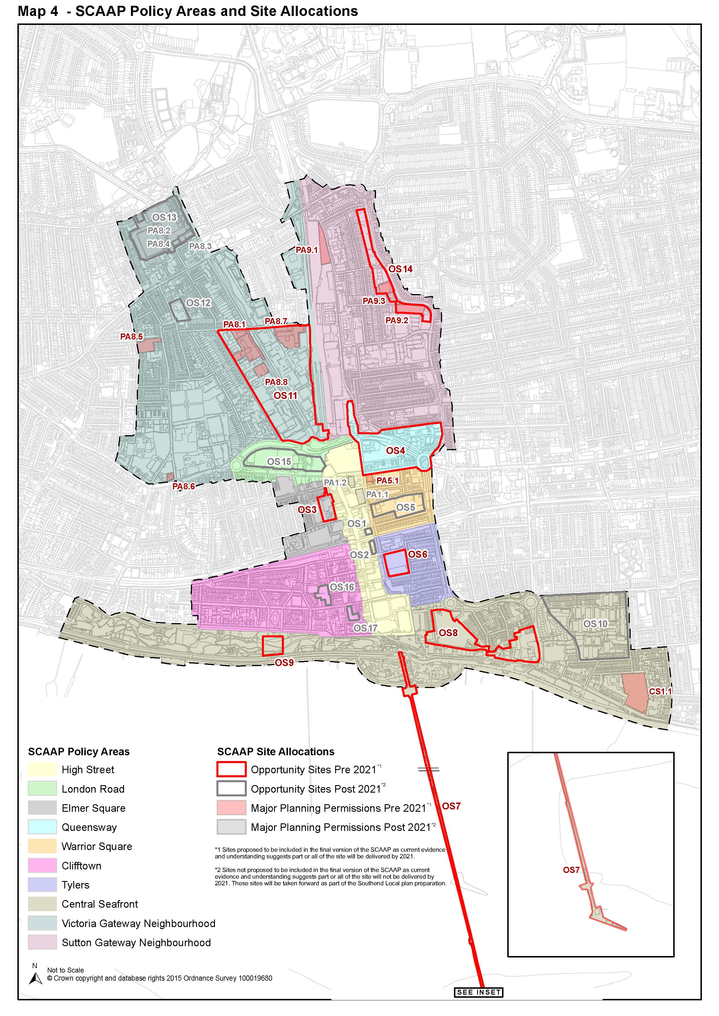
142 This section introduces the Policy Areas and their key Development Principles. Some of these Policy Areas contain allocated sites, comprising of Opportunity sites and Major Planning Permissions (with potential housing allocation) that establish parameters for development in specific locations.
143 The boundary of each Policy Area and Site Allocation can be viewed via the Policies Map and Map 4.
144 This preparatory version of the SCAAP sets out all known major potential development sites within the central area, which are not being developed under permitted development rights. However, the final version of the SCAAP will only include sites that are deliverable by 2021 (Map 5), the end of the Core Strategy plan period. Sites that are to be developed after 2021 will not be included in the final version of the SCAAP. Instead, they will be taken forward as part of the preparation of the Southend Local Plan.
145 Table 5 and the relevant site specific policies set out below outline which sites are considered to be deliverable by 2021 and those which will be delivered during the next plan period, i.e. preparation of the Southend Local Plan. The Council is seeking comment on the likelihood of these deliverable timescales. For those sites included in the final version of the SCAAP there must be clear evidence of deliverability by 2021, which can be presented at examination.
146 The non-allocation of a site on the Policies Map and Map 4 (i.e. post 2021) will not prevent the site from being implemented prior to 2021. The timescales provided purely reflect current published evidence and the understanding regarding the likely implementation of the sites. Any planning application proposed in the SCAAP area on any site would be determined on its merit taking into account adopted and emerging planning policies and any other material considerations.
147 Within Table 5 Opportunity Sites are referenced as 'OS', all remaining sites without an 'OS' reference are Major Planning Permissions as of April 2014. A list of all major planning permissions is also set out in Appendix 7. The base date of these planning permissions is April 2014. The next version of the SCAAP, to be published in 2016, will roll forward the planning permissions base date to 2015.
|
Policy Area/ Site Allocations |
Proposed additional uses (summary) |
Indicative Dwelling Capacity |
Phasing |
|||
|
Gross |
Net |
|||||
|
High Street |
||||||
|
OS1 |
Whitegate Road |
Residential, Office, Retail/ Restaurant |
15 |
15 |
Post 2021 |
|
|
OS2 |
Pitmans Close |
Residential, Office, Retail |
15 |
15 |
Post 2021 |
|
|
PA1.1 |
Maitland House |
Residential |
98 |
98 |
Post 2021 |
|
|
PA1.2 |
4 Southchurch Rd |
Residential, Restaurant |
24 |
24 |
Post 2021 |
|
|
London Road |
||||||
|
OS15 |
Sainsbury's & Adjacent Buildings |
Office, Residential, Town Centre Uses |
150 |
150 |
Post 2021 |
|
|
Elmer Square |
||||||
|
OS3 |
Elmer Square Phase 2 |
Educational & Supporting uses |
- |
- |
Pre 2021 |
|
|
Queensway |
||||||
|
OS4 |
Queensway |
Residential, Social & Community Uses, Retail |
1000 |
600 |
Pre 2021 |
|
|
Warrior Square |
||||||
|
OS5 |
Warrior Square |
Residential, Office/ Community Uses |
94 |
94 |
Post 2021 |
|
|
PA5.1 |
18 - 20 Southchurch Rd |
Residential |
16 |
16 |
Pre 2021 |
|
|
Clifftown |
||||||
|
OS16 |
Clarence |
Cafes, Offices/ Residential |
38 |
38 |
Post 2021 |
|
|
OS17 |
Alexander |
Retail, Cafes, Residential |
57 |
57 |
Post 2021 |
|
|
Tylers |
||||||
|
OS6 |
Tylers |
Retail, Residential, Potential Travel Centre |
80 |
80 |
Pre 2021 |
|
|
Central Seafront |
||||||
|
OS7 |
Southend Pier |
Cultural and leisure uses, including cafes, restaurants, small shops |
- |
- |
Pre 2021 |
|
|
OS8 |
Seaways and Marine Parade |
Residential, leisure, tourism, restaurants, Cinema, hotel |
340 |
340 |
Pre 2021 |
|
|
OS9 |
New Southend Museum |
Museum |
- |
- |
Pre 2021 |
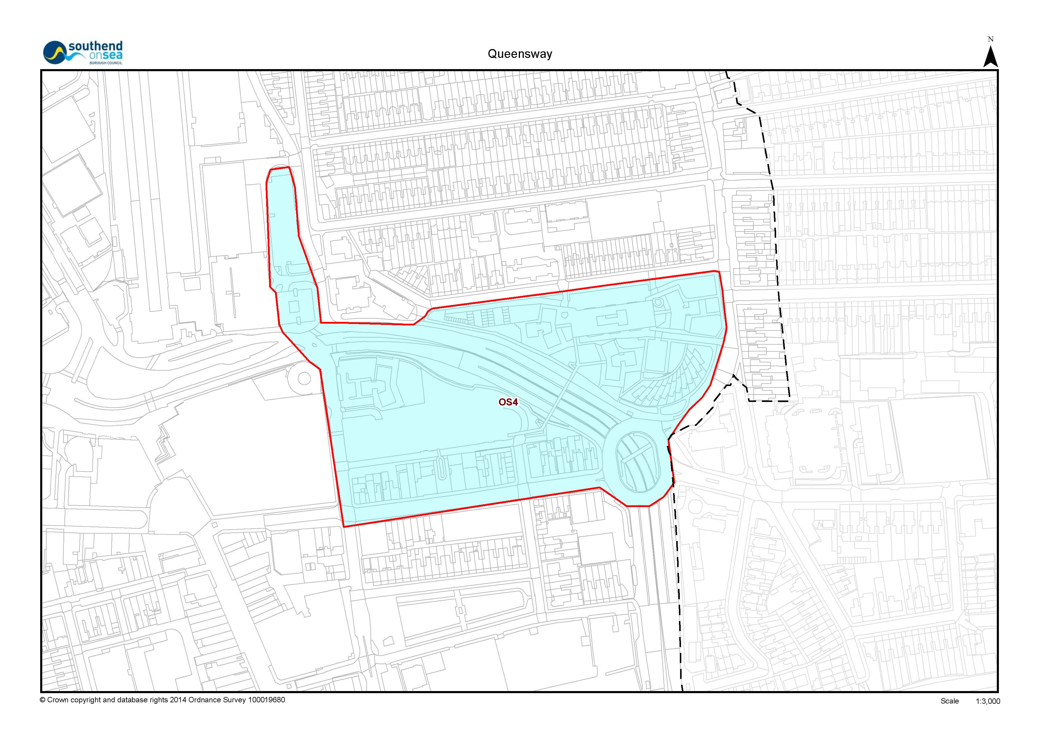
|
|
OS10 |
Woodgrange |
Residential |
- |
- |
Post 2021 |
|
|
CS1.1 |
Esplanade House |
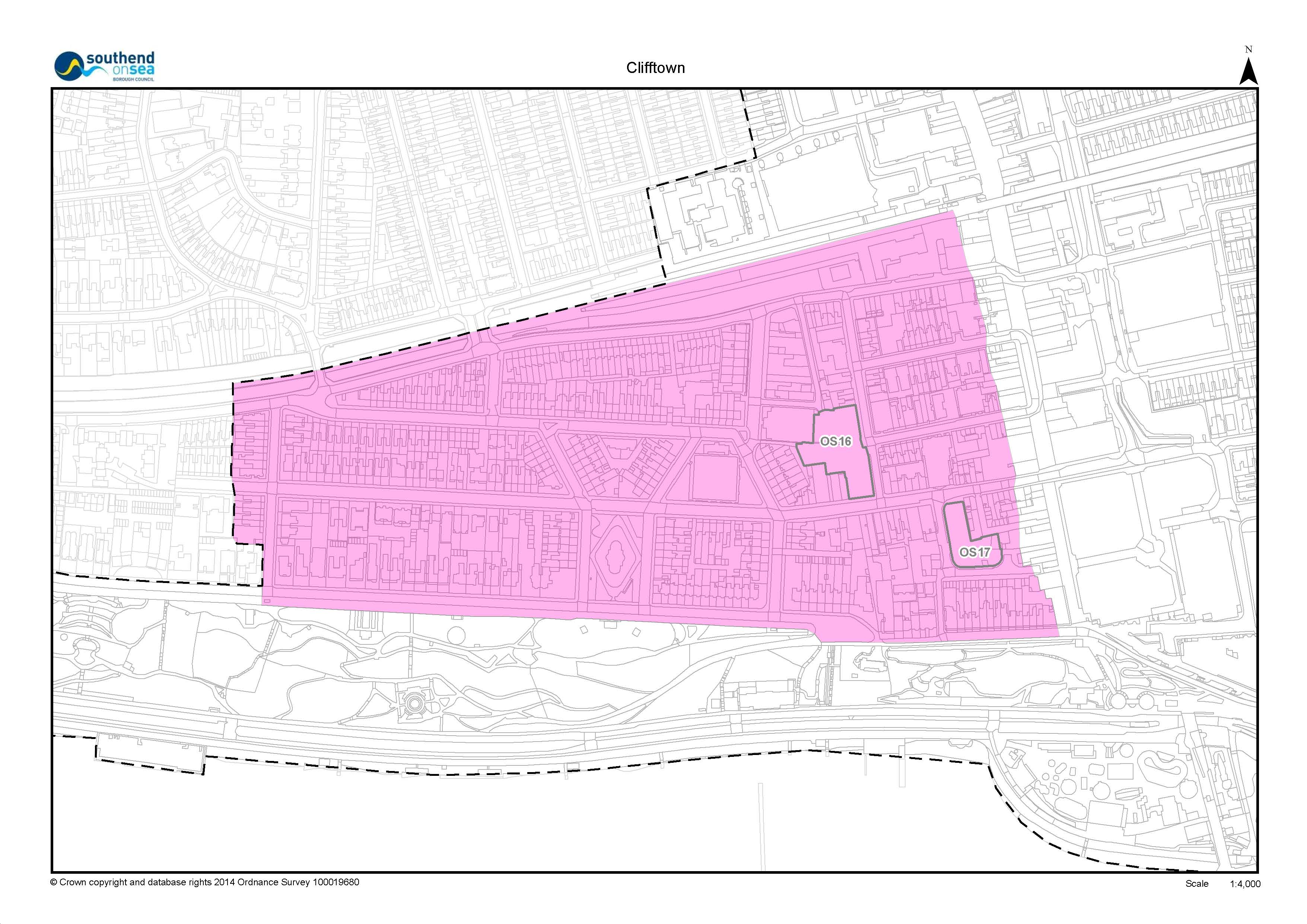
Residential, Convenience Retail, Restaurant |
266 |
216 |
Pre 2021 |
|
|
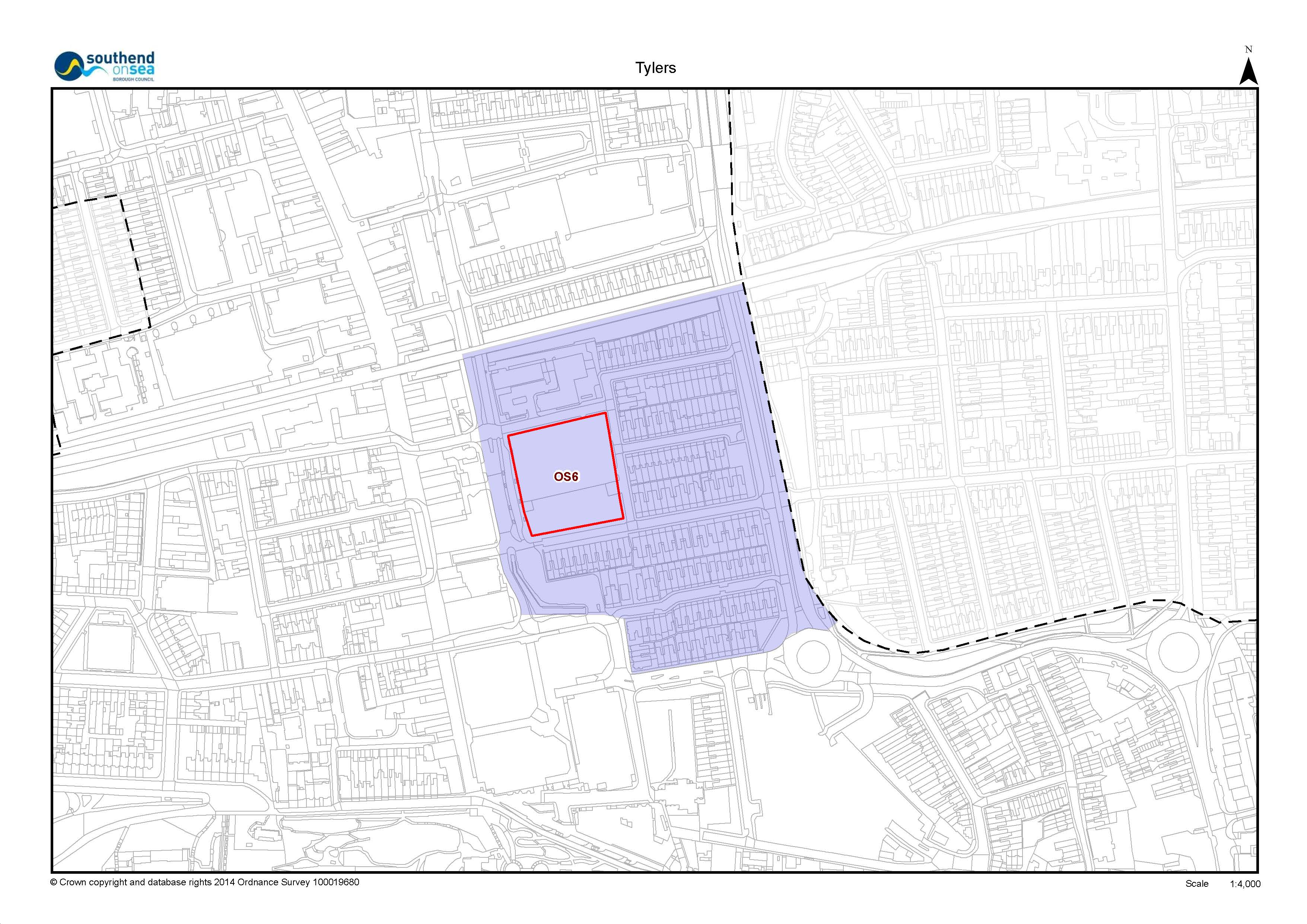
Victoria Neighbourhood |
||||||
|
OS11 |
Victoria Avenue* |
Residential, Office, Convenience Retail, Leisure, Cafes , Community Facilities |
1084 |
1084 |
Pre 2021 |
|
|
PA8.1 |
Heath House And Carby House |
Residential, Convenience Retail |
280 |
280 |
Pre 2021 |
|
|
PA8.7 |
Carnarvon Road |
Residential |
131 |
131 |
Pre 2021 |
|
|
PA8.8 |
Victoria House |
Residential, Convenience Retail |
40 |
40 |
Pre 2021 |
|
|
OS12 |
Water Board Site |
Cultural and creative uses, live work units & Residential |
30 |
30 |
Post 2021 |
|
|
OS13 |
Roots Hall* |
Mixed-use Scheme |
290 |
276 |
Post 2021 |
|
|
PA8.2 |
Roots Hall Stadium |
Residential, Convenience Retail |
272 |
229 |
Post 2021 |
|
|
PA8.3 |
297 Victoria Avenue |
Residential |
30 |
30 |
Post 2021 |
|
|
PA8.4 |
25 Roots Hall Avenue |
Residential |
18 |
18 |
Post 2021 |
|
|
PA8.5 |
Salisbury Avenue and North Road |
Residential |
43 |
43 |
Pre 2021 |
|
|
PA8.6 |
175 London Road |
Residential, Convenience Retail |
27 |
27 |
Pre 2021 |
|
|
Sutton Neighbourhood |
||||||
|
OS14 |
Sutton Road* |
Residential, Community Uses |
254 |
254 |
Pre 2021 |
|
|
PA9.2 |
257 - 285 Sutton Road |
Residential |
97 |
86 |
Pre 2021 |
|
|
PA9.3 |
319 - 321 Sutton Road |
Residential |
32 |
32 |
Pre 2021 |
|
|
PA9.1 |
Kenway |
Residential, Office |
45 |
45 |
Pre 2021 |
|
*Grey Highlighting denotes instances where Major Planning Permissions are within an Opportunity site (highlighted in darker grey). Refer to Map 4.

148 The policies are not explicit on the precise quantum of development, which leaves flexibility as development proposals come forward. Nevertheless, the scope for development, suitable uses and the deliverability of proposals is explored and presented in this section.
149 Applicants should demonstrate that they have considered and responded to the range of uses and site specific guidance identified in the policies in preparing their planning applications.
150 Informal planning guidance in the form of Development Briefs may be prepared for individual Policy Areas and Opportunity Sites, as necessary and appropriate, to provide greater clarity and guide delivery and implementation.
5.2 High Street Policy Area
The High Street, along with The Victoria and The Royals shopping centres, will form part of a vibrant and successful Town Centre Shopping Area, being the destination of choice within the sub-region.
A vibrant and viable Town Centre will be complemented by a variety of town centre uses, such as cafes and restaurants (particularly around new and improved public spaces), which enhance the experience for visitors, residents and workers and extend the economy throughout the day and into the evening.
The High Street will act as a spine providing safe quality pedestrian links to the adjoining policy areas, in particular the seafront.
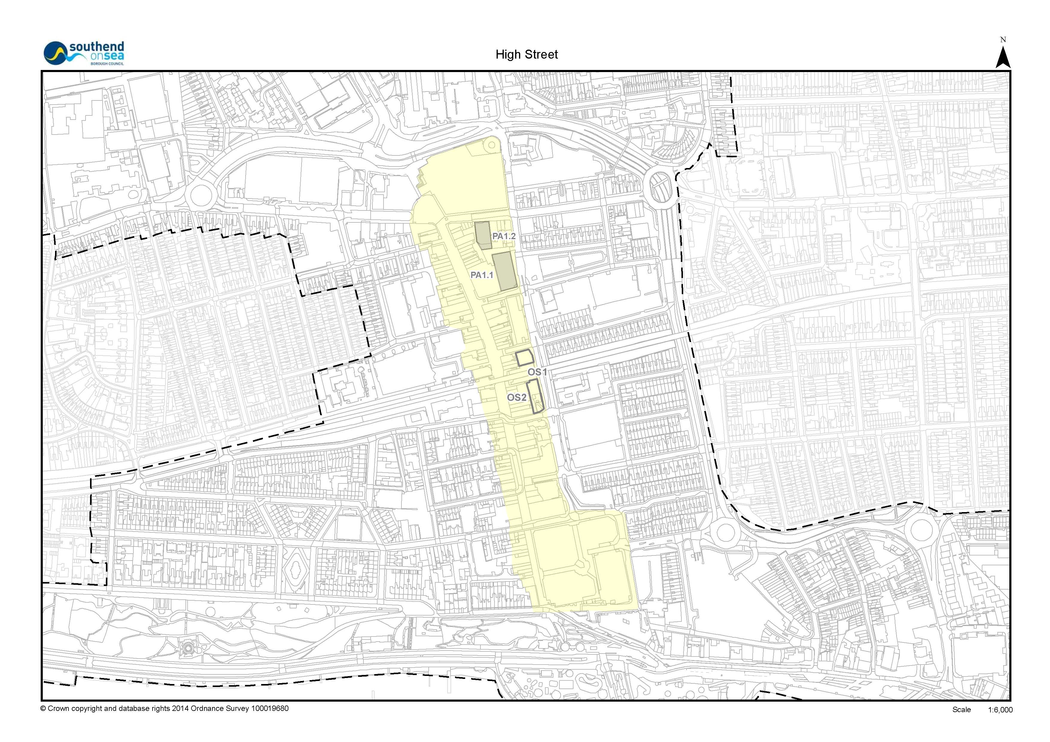
151 The High Street is almost 800 metres in length. It is anchored in the north by The Victoria Shopping Centre and in the south by The Royals Shopping Centre where, via Pier Hill, there is a continuous link to the Central Seafront Policy Area.
152 The High Street, along with The Victoria and The Royals shopping centres, falls within the Town Centre Primary Shopping Area that is a sub-regional comparison shopping destination and the first preference for all forms of retail and town centre uses within Southend.
153 There are two Opportunity Sites within the High Street Policy Area:
- Opportunity Site 1: Whitegate Road, approximately 0.08ha, is a vacant site where development would contribute to enhancing the townscape. In the past permission has been granted (now expired) for a four storey office building with restaurant on the ground floor. Such a development would not be in line with the objectives for the High Street Policy Area.
- Opportunity Site 2: Pitmans Close, approximately 0.09ha, is currently occupied to the south by modern public toilets, however in the longer term a well-designed development that provides active frontages could help to raise the profile of the area.
- The High Street forms part of the Primary Shopping Area. The Council will promote enhanced retail floorspace and support Town Centre uses that contribute to the vitality and viability of the centre in accordance with Policy DS1.
- Development proposals that would help to deliver the
following, will be supported in principle:
- A net increase in dwellings above existing or new commercial development, where appropriate;
- The conservation and restoration of historic shopfronts (including frontages of townscape merit);
- Mixed-use development with active ground floor frontages;
- Energy efficiency, including opportunity for decentralised energy supply, and the retrofit of existing development in line with local policy.
- In order to enhance the High Street experience, the
following improvements will be promoted as development
opportunities arise:
- Transforming and enhancing the existing public space at Victoria Circus, enabling use for public events;
- Creating a new public space to the High Street either side of the railway bridge, including a creative lighting scheme;
- Further connect the Town Centre to the Central Seafront Policy Area by a series of multi-level spaces, including an upper level public piazza.
- maintain and improve the High Street as public space for pedestrians, addressing the principles of the Southend Streetscape Manual and by providing quality landscapes including urban greening and tree planting;
- Pedestrianisation and enhancement of a number of the High Street's inter-linking access ('stub') roads supporting access to car parks, green space, retail and surrounding neighbourhoods;
- At key junction points, create a strong public realm to emphasise the intersection of east-west routes;
- The following sites, as identified on the Policies Map,
are considered to be suitable primarily for residential
use:
Site Reference
Site Name
Planning Status*
Indicative number of dwellings
Timescale for delivery
PA1.1
Maitland House
NS
98
Post 2021
PA1.2
4 Southchurch Rd
NS
24
Post 2021
- The following Opportunity Sites, as identified on the
Policies Map, are considered to be suitable for residential
development and complimentary town centre uses:
Site Reference
Site Name
Planning Status*
Indicative number of dwellings
Timescale for delivery
OS1
Whitegate Road
EA
15
Post 2021
OS2
Pitmans Close
NA
15
Post 2021
*Planning Status as of April 2014. NS = Note Started with full planning permission. EA = Expired Application. NA = New Allocation
i. Within Opportunity Site 1: Whitegate Road, planning permission will be granted for mixed-use development including high quality office space and residential to upper floors and active commercial use, such as retail and restaurants, at ground floor. The design, access and layout of any development should include attractive and active frontages onto Whitegate and Chichester Road, complementing the character of, and enhancing links between, the High Street and the Warrior Square Policy Area.
ii. Within Opportunity Site 2: Pitmans Close, planning permission will be granted for mixed-use redevelopment of this site for high quality office space and residential, with opportunity for commercial use, such as retail, at ground floor. The design, access and layout of any development should include attractive and active frontages, complementing the character of and enhancing links between the High Street and the Tylers Policy Area.
(33) Question 20: Do you agree with the proposed approach to managing development within the High Street Policy Area? Please explain your answer.
If you consider that the timescales for delivering development sites OS1, OS2, PA1.1 and PA1.2 should be different then please provide evidence to support a revised timeframe.
|
Core Strategy Objectives Strategic Objective 1 Strategic Objective 4 Strategic Objective 5 Strategic Objective 8 Strategic Objective 14 Strategic Objective 15 Strategic Objective 18 |
Policies KP1: Spatial Strategy KP2: Development Principles KP3: Implementation and Resources CP1: Employment Generating Development CP2: Town Centre and Retail Development CP4: The Environment and Urban Renaissance |
|
Development Management DPD |
Policies DM1: Design Quality DM2: Low Carbon Development and Efficient Use of Resources DM5: Southend-on-Sea's Historic Environment DM15: Sustainable Transport Management |
|
Southend Central AAP Objectives Objective 1 Objective 2 Objective 3 Objective 4 Objective 5 Objective 6 Objective 7 Objective 8 Objective 9 Objective 10 |
Policies DS1: Maintaining a Prosperous Retail Centre DS2: Key Views DS3: Landmarks and Landmark Buildings DS4:Flood Risk Management and Sustainable Drainage DS5: Transport, Access and Public Realm PA2: London Road Policy Area Development Principles PA3: Elmer Square Policy Area Development Principles PA4: Queensway Policy Area Development Principles PA5: Warrior Square Policy Area Development Principles PA6: Clifftown Policy Area Development Principles PA7: Tylers Policy Area Development Principles CS1: Central Seafront Policy Area Development Principles PA8: Victoria Gateway Neighbourhood Policy Area Development Principles PA9: Sutton Gateway Neighbourhood Policy Area Development Principles |
*This Policy Linkage Box provides a summary of key inter-related local policies. Other planning policy and guidance not listed here may also be applicable and, therefore, a full assessment should be undertaken.
The policy approach to the management of development within the High Street Policy Area has been reviewed in the context of current guidance and evidence. Subsequently, it has been determined that the boundary of the Policy Area should be revised to include both The Royals and The Victoria shopping centres, in recognition of their role as 'anchors' to the northern and southern end of the High Street. The Whitegate Road and Pitmans Close Opportunity Sites have also been bought into the policy and supporting text for the High Street Policy Area, previously having been incorrectly included within the supporting text / policy for the Warrior Square and Tylers Policy Areas respectively. Previous plan references: Proposal Site Policy PS5b: Whitegate Road and Proposal Site Policy PS7b: Pitman's Close.
It is considered that the policy approach is appropriate and effective. This should be read in conjunction with the criteria based policies in the development strategy section within this Plan, together with relevant Policy Areas and Opportunity Sites and relevant policies within the Core Strategy and Development Management Document.
The previous iterations of the SCAAP referred to Quarters, Gateway Neighbourhoods and Proposal Sites. Following a review of the Plan, these terms have been revised and Quarters and Gateway Neighbourhoods are referred to within the Preferred Approach version of the SCAAP as 'Policy Areas', and Proposal Sites as 'Opportunity Sites'. Policy criterion relating to Opportunity Sites has now been incorporated into the development principles of the Policy Area.
Within the previous version of the SCAAP (2011), this policy was referred to as Policy DP1: The High Street Development Principles.
- National Planning Policy Framework
- Southend Core Strategy DPD (2007)
- Central Area Masterplan (2008)
- SCAAP Issues and Options version (2010)
- SCAAP (superseded) Proposed Submission version (2011)
- Consultation Statements, responding to comments made on previous versions of the SCAAP
- Sustainability Appraisal, HRA and EQIA
- Southend Retail and Town Centre Study (2011)
- The Management of Designated Shopping Frontages in Southend-on-Sea -Technical Report (2013, 2015)
- Southend Employment Land Review (2010)
- Annual Monitoring Reports
5.3 London Road Policy Area
The London Road Policy Area will be a vibrant gateway to the Town Centre, providing high quality office space, shops, cafes/restaurants, and homes above street level. This will be complemented by public realm enhancements, public art installations, creative lighting, and landscaping to create a pedestrian-priority public space with opportunities for outside seating to cafes/restaurants.
Permeability for pedestrians and cyclists will be enhanced at this key gateway to the town centre, including improved links to/from the Victoria Gateway Policy Area as part of the 'Victoria Gateway' public realm improvement scheme.
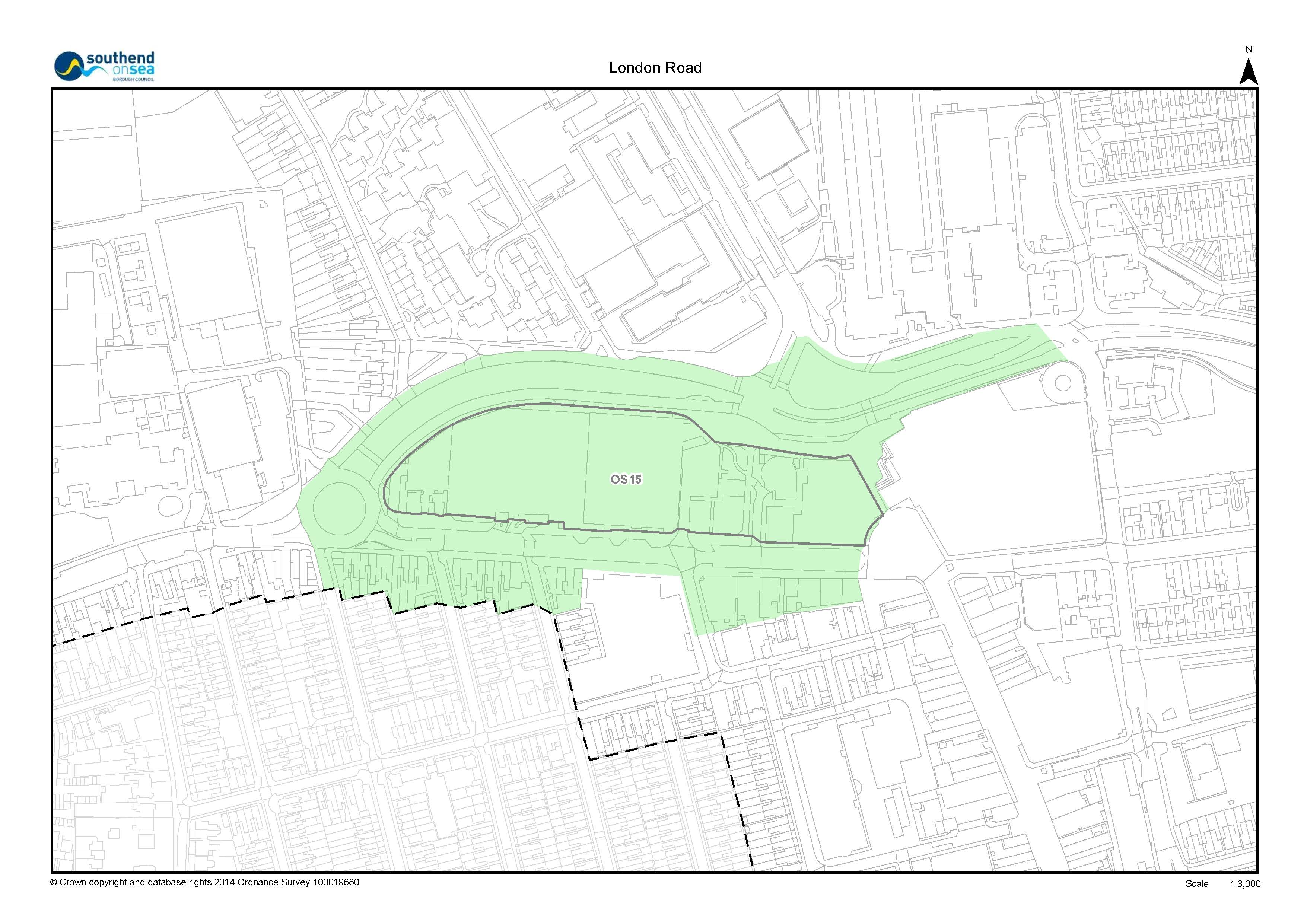
154 The Policy Area, as defined on the Policies Map, is one of the main entry points to the Town Centre and High Street and is characterised by a varied architecture dominated by the Odeon Cinema and Sainsbury's food store, both of which present blank, 'inactive' frontages onto the Queensway dual carriage way. There is opportunity for this to be addressed within any development proposals to ensure that active frontages are created, including opportunities for public art and landscape design to existing buildings.
155 London Road has transformed in recent years into a vibrant area of cafés and restaurants that, together with the cinema and shops, provides day time and evening attractions. Consequently there is significant pedestrian activity in the area including movements to and from the High Street. Forming part of a future phase of the Victoria Gateway scheme, there is opportunity to improve pedestrian and cycle links to and from London Road and Queensway dual carriageway and the Queensway Policy Area, public transport interchanges, and Elmer Square Policy Area.
156 There is a principal taxi rank in London Road which serves the Town Centre. The width of the road also encourages the circulation of private cars; there is potential for this to be established as a pedestrian-priority space, retaining provision for the taxi rank within the Policy Area in discussion with taxi providers.
157 The Policy Area includes a large convenience retail food store (Sainsbury's) that attracts a high footfall and contributes to the convenience retail offer of the Town Centre. In the event of the redevelopment of the Sainsbury's site there is potential to accommodate a mixed-use development with town centre uses, that could include convenience retail, offices and residential (to upper floors). If this site was to be developed it is important that the town centre is anchored by a large scale convenience retail offer to contribute towards its continued vitality and viability.
- Promote Town Centre uses that deliver the aims for the Policy Area and support the vitality and viability of the town centre, including high quality office space, retail floorspace, cafes/restaurants, and residential (to upper floors).
- Encourage active ground floor frontages to new and existing buildings on London Road and Queensway dual carriage way;
- Support development proposals that promote the provision of a street market on a new pedestrianised length of London Road, which connects well with the High Street;
- Support the provision of additional Higher and Further Education facilities based on an assessment of the expansion needs of the University of Essex and South Essex College;
- Promote energy efficiency, including opportunity for decentralised energy supply, and the retrofit of existing development in line with local policy.
- In the event of redevelopment of the Sainsbury's site a development brief will be produced to guide a landmark, mixed-use development on the site.
- Promote the following access and public realm
improvements:
- pedestrianisation of the eastern end of the London Road, linking with the pedestrianised High Street, to provide an attractive, coordinated public realm with opportunities for outside seating areas to cafes/restaurants to enliven the streetscene, with priority also given to cyclists;
- relocation of taxi facilities to west of College Way on London Road, its location and facilities to be determined in consultation with taxi providers
- short and direct access maintained to the University Car Park, College Way, via London Road;
- junction improvements at Queensway dual carriageway / London Road to improve pedestrian and cycle crossing;
- provision for mixed mode - pedestrian and cycle priority route from Queensway dual carriage way to the Elmer Square Policy Area via London Road, College Way, Queens Road, Elmer Avenue and Luker Road;
- tree planting and landscaping and good quality permeable surface materials where appropriate
- seek provision of public art and integrated signage and artwork that combine with more traditional signage to signal entry to the Town Centre from Queensway dual carriage way/ Southend Victoria Railway Station and clear way-finding.
The following site is expected to be delivered in the period after 2021, which is beyond the plan period for the SCAAP. Nevertheless, it is presented here to allow for further evidence to be submitted that can demonstrate that it is deliverable by 2021 and therefore should be allocated within the SCAAP. If they are not shown to be deliverable by 2021 then they will be included within the preparation of the new Southend Local Plan in accordance with the Local Development Scheme:
- The following Opportunity Site, as identified on the
Policies Map, is considered to be suitable for mixed use
development:
Site Reference
Site Name
Planning Status*
Indicative number of dwellings
Timescale for delivery
OS15
Sainsbury's & Adjacent Buildings
NA
150
Post 2021
*Planning Status as of April 2014. NA = New Allocation
i. In the event of Sainsbury's relocating, the Council will work with land and property owners and developers to prepare a planning brief to secure the comprehensive redevelopment of the area to deliver the development principles for the quarter, and to provide:
- mixed-use development with town centre uses, that could include convenience retail, offices and residential (to upper floors);
- design and layout solutions that allow for:
01. attractive frontages to Queensway elevation coupled with arcaded route to London Road and active frontages with mixed town centre uses to all other frontages;
02. high quality pedestrian environments and improved permeability from Queensway to London Road and the High Street;
03. provision of public art, particularly to Queensway to signal gateway entry to the Town Centre.
If you consider that the timescale for delivering OS15 should be different then please provide evidence to support a revised timeframe.
|
Core Strategy Objectives Strategic Objective 1 Strategic Objective 4 Strategic Objective 5 Strategic Objective 8 Strategic Objective 14 Strategic Objective 15 |
Policies KP1: Spatial Strategy KP2: Development Principles KP3: Implementation and Resources CP1: Employment Generating Development CP2: Town Centre and Retail Development CP4: The Environment and Urban Renaissance |
|
Development Management DPD |
Policies DM1: Design Quality DM2: Low Carbon Development and Efficient Use of Resources DM15: Sustainable Transport Management |
|
Southend Central AAP Objectives Objective 1 Objective 2 Objective 3 Objective 4 Objective 5 Objective 6 Objective 7 Objective 8 Objective 9 Objective 10 |
Policies DS4:Flood Risk Management and Sustainable Drainage DS5: Transport and Accessibility PA1: High Street Policy Area Development Principles PA4: Queensway Policy Area Development Principles PA8: Victoria Gateway Neighbourhood Policy Area Development Principles PA9: Sutton Gateway Neighbourhood Policy Area Development Principles |
*This Policy Linkage Box provides a summary of key inter-related local policies. Other planning policy and guidance not listed here may also be applicable and, therefore, a full assessment should be undertaken.
The policy approach to the management of development within the London Road Policy Area has been reviewed in the context of current guidance and evidence. Subsequently, it has been determined that the site allocation from the 2011 Proposed Submission version of the SCAAP (formerly referred to as Proposal Site Policy PS2a: Sainsbury's and adjacent buildings, London Road) should be removed from the plan. In the event of the redevelopment of the Sainsbury's site there is potential to accommodate a mixed-use development with town centre uses and this is set out in the Development Principles for the Policy Area.
Within the 2011 Proposed Submission version of the Plan, Policy PA2 was referred to as Policy DP2: Queensway and London Road/Broadway Development Principles.
It is considered that the policy approach is appropriate and effective. This should be read in conjunction with the criteria based policies in the development strategy section within this Plan, together with relevant Policy Areas and Opportunity Sites and relevant policies within the Core Strategy and Development Management Document.
- National Planning Policy Framework and Guidance
- Central Area Masterplan (2008)
- SCAAP Issues and Options version (2010)
- SCAAP (superseded) Proposed Submission version (2011)
- Consultation Statements, responding to comments made on previous versions of the SCAAP
- Sustainability Appraisal, HRA and EQIA
- Southend Retail and Town Centre Study (2011)
- The Management of Designated Shopping Frontages in Southend-on-Sea -Technical Report (2013, 2015)
- Southend Employment Land Review (2010)
- Annual Monitoring Reports
This list is not exhaustive. Full evidence base is available on the Council's website.
5.4 Elmer Square Policy Area
Elmer Square will be the heart of the educational hub in Southend providing state of the art library and learning facilities set within a quality public realm with integrated pedestrian links with the High Street and London Road policy areas.
Ground floors of all buildings will be visually active, encouraging stronger engagement with the public space, the Forum and academic buildings and reinforcing Queens Road as a secondary shopping area.
Future development in this area will be well-designed, innovative and complementary to the Forum and phased to meet the expansion and growth needs of the University of Essex and South Essex College.
158 Elmer Square is on the edge of the Town Centre in an area of transition with the residential areas to the west. The area contains a state of the art library 'The Forum' and learning facilities and is complemented by the adjacent higher and further education campuses. Queens Road to the north of the Policy Area contains a range of popular cafes and small scale retail units and provides an important and vibrant link with the High Street.
159 The University Square student accommodation is situated at the northern extent of the Policy Area, providing a distinctive, local landmark as well as public car parking that will be maintained.
160 Significant improvements have been made to the public realm; nevertheless, the backs of buildings on the High Street that front onto the public open space have a detrimental visual impact.
161 Opportunity Site, OS 3 Elmer Square Phase 2 provides the opportunity to develop additional educational facilities, of a high quality design that complements the Forum development and reinforces key links through the site.
- promote educational and supporting uses that deliver the aims of the Policy Area;
- Promote energy efficiency, including opportunity for decentralised energy supply, and the retrofit of existing development in line with local policy.
- promote the following access and public realm
improvements:
- creation of new semi-pedestrianised and cycle space along Queens Road between Elmer Avenue and the High Street;
- provision for 'mixed mode - pedestrian and cycle priority' route from Queensway to Luker Road via the London Road Policy Area, College Way, Queens Road and Elmer Avenue;
- provision of public art and integrated signage and artwork to building elevations that combine with more traditional signage to signal entry to the Town Centre where appropriate, and clear way-finding;
- pursue urban greening projects, including the use of green walls and roof gardens and the creation of green space within new development.
- require planning applications for new student accommodation to be accompanied by a long term management and maintenance plan to ensure the development has a positive impact on local amenity and environment for the lifetime of its use.
- The following Opportunity Site, as identified on the
Policies Map, is allocated primarily for educational use
(Use Class D1):
Site Reference
Site Name
Planning Status*
Indicative number of dwellings
Timescale for delivery
OS3
Elmer Square Phase 2
NA
N/A
Pre 2021
*Planning Status as of April 2014. NA = New Allocation
i. Within Opportunity Site 3: Elmer Square Phase 2, planning permission will be granted for educational and supporting uses to complement Phase 1 and to further reinforce Elmer Square as the heart of the learning hub.
ii. Opportunities to improve the visual appearance to the rear of buildings on the High Street that front onto the public space, and associated public realm enhancements including surfacing, lighting and landscaping to complement Phase 1 will also be promoted within Opportunity Site 3.
If you consider that the timescale for delivering OS3 should be different then please provide evidence to support a revised timeframe.
|
Core Strategy Objectives Strategic Objective 2 Strategic Objective 4 Strategic Objective 13 Strategic Objective 15 Strategic Objective 18 |
Policies Policy KP1: Spatial Strategy Policy KP2: Development Principles KP3: Implementation and Resources Policy CP4: The Environment and Urban Renaissance Policy CP6: Community Infrastructure |
|
Development Management DPD |
Policies DM1: Design Quality DM2: Low Carbon Development and Efficient Use of Resources DM15: Sustainable Transport Management |
|
Southend Central AAP Objectives Objective 1 Objective 2 Objective 3 Objective 4 Objective 5 Objective 6 Objective 10 |
Policies DS3: Landmark and Landmark Buildings DS4:Flood Risk Management and Sustainable Drainage DS5: Transport, Access and Public Realm |
*This Policy Linkage Box provides a summary of key inter-related local policies. Other planning policy and guidance not listed here may also be applicable and, therefore, a full assessment should be undertaken.
The policy approach to the management of development within the Elmer Square Policy Area has been reviewed in the context of current guidance and evidence. Subsequently, it has been determined that the boundary of the site allocation from the 2011 Proposed Submission version of the SCAAP (formerly referred to as Proposal Site Policy PS3a: Elmer Square Proposal Site) should be reviewed and updated following the completion of Phase 1 of the Elmer Square redevelopment. The boundary of Opportunity Site 3: Elmer Square Phase 2 therefore reflects this. Within the 2011 Proposed Submission version of the Plan, Policy PA3 was referred to as Policy DP3: Elmer Square Development Principles.
It is considered that the policy approach is appropriate and effective. This should be read in conjunction with the criteria based policies in the development strategy section within this Plan, together with relevant Policy Areas and Opportunity Sites and relevant policies within the Core Strategy and Development Management Document.
The previous iterations of the SCAAP referred to Quarters, Gateway Neighbourhoods and Proposal Sites. Following a review of the Plan, these terms have been revised and Quarters and Gateway Neighbourhoods are referred to within the Preferred Approach version of the SCAAP as 'Policy Areas', and Proposal Sites as 'Opportunity Sites'. Policy criterion relating to Opportunity Sites has now been incorporated into the development principles of the Policy Area.
- National Planning Policy Framework and Guidance
- Central Area Masterplan (2008)
- SCAAP Issues and Options version (2010)
- SCAAP (superseded) Proposed Submission version (2011)
- Consultation Statements, responding to comments made on previous versions of the SCAAP
- Sustainability Appraisal, HRA and EQIA
- Elmer Square Development Brief (2009)
- Annual Monitoring Reports
This list is not exhaustive. Full evidence base is available on the Council's website.
5.5 Queensway Policy Area
The development of the Queensway Policy Area will be based on a long term strategy that secures the regeneration of the area to create a balanced community, supported by social and community infrastructure, and complemented by active ground floor uses to Chichester Road and the secondary shopping frontage along Southchurch Road, an enhanced public realm and landscaping as well as well-defined public and private green open spaces.
It will be residential-led and create a vibrant, sustainable neighbourhood with a distinctive character and innovative housing typologies, providing opportunities for a range of building heights and densities suitable to the location. The development will be an exemplar of successful design led estate regeneration, based on a partnership approach.
Queensway dual carriageway will be transformed, ensuring that vulnerable road users are prioritised and that the area is safely accessible by foot and bicycle. The environment will be more user friendly with appropriately sited pedestrian and cycle crossings.
Development will reinforce Southchurch Road as a secondary shopping area and provide new employment opportunities.
162 Queensway Opportunity Site 4 now encompasses the whole of the Queensway Policy Area. This is owing to the 'Better Queensway' project as described below.
163 Queensway Policy Area (Opportunity Site 4 OS4) is dominated by a swathe of 1960s residential blocks. Queensway dual carriageway acts as both a major highway approach to the Town Centre and a ring road around it. Its scale and design acts as a barrier between the Town Centre and its outlying neighbourhoods, despite this its verges are amongst some of the most significant green wedges in the Town Centre, but as green spaces they are not useable given their nature and there is opportunity to enhance these spaces.
164 The tower blocks provide redevelopment potential (including the re-provision of social housing) and associated opportunities to enhance the setting of All Saints Church (locally listed) and Porters (Grade 1 listed) heritage assets.
165 To the north-west, at Short Street is the cleared site of the former Focus Youth Centre and a public car park, which provides development opportunity. Locations such as Coleman Street will provide opportunity to re-establish urban grain by providing residential development that complements existing dwellings in the streetscene.
166 To the south, Southchurch Road (secondary shopping frontage) contains a mix of older, low rise, buildings that have a poor visual appearance. Even so, Southchurch Road plays an important role as a secondary retail and commercial frontage and is currently a principal route for traffic entering the Town Centre from the east in order to use the car parks in and around the Chichester Road area.
167 The Council has initiated the 'Better Queensway' project, which aims to improve Queensway to be a real part of central Southend, and seen as an attractive element of the town centre. It will be an area that is part of the overall Southend community that people want to visit, spend time in and live due to its improved and welcoming surroundings.
168 Regeneration and development in the Queensway Policy Area will be the catalyst for wider regeneration in Southend Central Area, broadening the demographic and increasing the number of residents living in the central area, generating more activity and demand for local services.
169 The initiative provides significant opportunity for redevelopment and regeneration to re-establish the historic urban grain and uplift the image of the area, complemented by enhancements to the carriageway and public realm and re-provision of social housing.
170 Chichester Road currently provides access through the Queensway Policy Area to the Warrior Square and Tylers Policy Areas and a number of Town Centre car parks, as well as being the major bus access to the Travel Centre in the Tylers Policy Area. The environmental quality of Chichester Road is very poor. Chichester Road is widely used by vehicles accessing the town centre car parks. Opportunity exists to enhance pedestrian links to the High Street Policy Area centre via Queensway and Chichester Road.
- Promote residential and supporting uses that deliver the aims for the Policy Area; support well-designed, sustainable buildings that are appropriate to the location in terms of use, scale, massing and detailed design and contribute positively to successful place making
- ensure that development will not result in a net loss of affordable housing provision, which includes the re-provision of social housing on the site as part of the regeneration of the site
- Support proposals for well-designed refurbishment or redevelopment of retail and commercial frontages to Southchurch Road, that are compatible with the Secondary Shopping Frontage designations
- Support new commercial development and community uses (see criteria 6) that provide activity to ground floor including offices to upper floors, will be promoted (particularly to Essex Street and Chichester Road frontages) where they contribute to the aims for the policy area
- Promote energy efficiency, including opportunity for decentralised energy supply, and the retrofit of existing development in line with local policy.
- Promote the provision of new social and community infrastructure, which may include facilities such as community centres and clubs, doctor and dental surgeries, and nurseries and childcare provision.
- promote the following access and public realm
improvements:
- improvements to the streetscape at Chichester Road opposite Victoria Shopping Centre to enhance the setting of new and existing buildings and improve the pedestrian experience, including improved pedestrian crossing points;
- improve connectivity and legibility to aid way finding and create a high quality pedestrian and cycling environment, enhancing links with the High Street, Elmer Square, Warrior Square, Victoria and Sutton Gateway Neighbourhood Policy Areas;
- provision of public art to enhance the urban environment, particularly to the Queensway carriage way frontage and at the junction with Sutton Road;
- create 'mixed mode - shared priority' route from Southchurch Road to Warrior Square via Warrior Square East;
- create 'mixed mode - pedestrian and cycle priority' route along Southchurch Road between Queensway and the High Street/Victoria Circus;
- improved crossings for pedestrians and cyclists and gateway improvements at the Queensway/Sutton Road Junction;
- improved crossing for pedestrians and cyclists at the Queensway/Short Street/Chichester Road junction in association with capacity requirements for development on the Queensway Opportunity Site (OS 4);
- Urban Greening to promote biodiversity and establish the Queensway Urban Park, through the preparation of a masterplan, which sensitively addresses and enhances the setting of Porters and All Saints Church and links well with Warrior Square Policy Area.
- Provide new public open space fronting Chichester Road, including appropriate crossing improvements on Chichester Road, to relieve the canyon effect of existing buildings and improve the environment for residents and visitors, encouraging walking and cycling.
- The following Opportunity Site, as identified on the
Policies Map, is considered suitable primarily for
residential development, supported by social and community
uses and retail provision:
Site Reference
Site Name
Planning Status*
Indicative number of dwellings
Timescale for delivery
OS4
Queensway
NA
1000
Pre 2021
*Planning Status as of April 2014. NA = New Allocation
If you consider that the timescale for delivering OS4 should be different then please provide evidence to support a revised timeframe.
|
Core Strategy Objectives Strategic Objective 3 Strategic Objective 4 Strategic Objective 6 Strategic Objective 7 Strategic Objective 10 Strategic Objective 13 Strategic Objective 14 Strategic Objective 15 Strategic Objective 18 |
Policies
KP1: Spatial Strategy KP2: Development Principles KP3: Implementation and Resources CP1: Employment Generating Development CP4: The Environment and Urban Renaissance CP6: Community Infrastructure CP 8: Dwelling Provision |
|
Development Management DPD |
Policies DM1: Design Quality DM2: Low Carbon Development and Efficient Use of Resources DM3: Efficient and Effective Use of Land DM7: Dwelling Mix, Size and Type DM8: Residential Standards DM15: Sustainable Transport Management |
|
Southend Central Objectives AAP Objective 1 Objective 2 Objective 3 Objective 4 Objective 5 Objective 6 Objective 8 |
Policies DS1: Maintaining a Prosperous Retail Centre DS2: Key Views DS3: Landmarks and Landmark Buildings DS4:Flood Risk Management and Sustainable Drainage DS5: Transport, Access and Public Realm PA1: High Street Policy Area Development Principles PA3: Elmer Square Policy Area Development Principles PA5: Warrior Square Policy Area Development Principles PA8: Victoria Gateway Neighbourhood Policy Area Development Principles PA9: Sutton Gateway Neighbourhood Policy Area Development Principles |
*This Policy Linkage Box provides a summary of key inter-related local policies. Other planning policy and guidance not listed here may also be applicable and, therefore, a full assessment should be undertaken
The policy approach to the management of development within the Queensway Policy Area has been reviewed in the context of current guidance and evidence. Subsequently, it has been determined that the boundary of the site allocation from the 2011 Proposed Submission version of the SCAAP (formerly referred to as Proposal Site Policy PS4a: Queensway House and adjacent buildings) should be reviewed and updated following the demolition of Queensway House and the Council's regeneration priorities for the area, which include the Coleman Street and Short Street sites. The boundary of Opportunity Site 4: Queensway therefore reflects this. Within the 2011 Proposed Submission version of the Plan, Policy PA4 was referred to as Policy DP4: Queensway and Southchurch Avenue Development Principles.
It is considered that the policy approach is appropriate and effective. This should be read in conjunction with the criteria based policies in the development strategy section within this Plan, together with relevant Policy Areas and Opportunity Sites and relevant policies within the Core Strategy and Development Management Document.
The previous iterations of the SCAAP referred to Quarters, Gateway Neighbourhoods and Proposal Sites. Following a review of the Plan, these terms have been revised and Quarters and Gateway Neighbourhoods are referred to within the Preferred Approach version of the SCAAP as 'Policy Areas', and Proposal Sites as 'Opportunity Sites'. Policy criterion relating to Opportunity Sites has now been incorporated into the development principles of the Policy Area.
- National Planning Policy Framework and Guidance
- Central Area Masterplan (2008)
- SCAAP Issues and Options version (2010)
- SCAAP (superseded) Proposed Submission version (2011)
- Consultation Statements, responding to comments made on previous versions of the SCAAP
- Sustainability Appraisal, HRA and EQIA
- Southend Retail and Town Centre Study (2011)
- The Management of Designated Shopping Frontages in Southend-on-Sea -Technical Report (2013, 2015)
- Southend Employment Land Review (2010)
- Strategic Housing Land Availability Assessment, and updates (2010, 2013)
- Strategic Housing Market Assessment (2013)
- Annual Monitoring Reports
This list is not exhaustive. Full evidence base is available on the Council's website.
5.6 Warrior Square Policy Area

Warrior Square will provide a tranquil contrast to the lively High Street area focused on its predominant small-scale residential character and the Warrior Square public open space.
All buildings will be well designed to respect the setting of the Warrior Square Conservation Area in terms of detailing, scale and massing. Landscaping, tree planting and other urban greening techniques will be employed, within new development to complement the existing green character of the area.
Access to Warrior Square from neighbouring policy areas and residential neighbourhoods will be enhanced and a legible network of pedestrian and cycle friendly routes will be formed.
171 Development within the Policy Area will need to sensitively address the setting of the Conservation Area in terms of scale, massing and detailed design. Warrior Square Opportunity Site (OS 5) presents the main development opportunity within the Policy Area and the provision of well-designed, sustainable building(s) that re-establishes the urban grain, being sensitive to the scale and massing of existing residential development on Whitegate Road, will be encouraged.
172 Residential-led development with car parking and the potential for appropriate supporting uses such as office development, particularly fronting Chichester Road, and community uses could be appropriate for the site and location. New development also provides the opportunity to bring activity and natural surveillance to Warrior Square Gardens.
173 Chichester Road presents a main thoroughfare within the Policy Area yet the quality of the streetscape is poorly defined in part, and provides scope for enhancements to be made to the public realm, such as upgraded footway surfaces, tree planting and public art and pedestrian and cycle links to and from the town centre and surrounding area, particularly the Queensway Policy Area via Chichester Road and Warrior Square East.
- promote residential-led mixed-use development that delivers the aims for the Policy Area, with active ground floor uses on Southchurch Road with residential and office above;
- conserve and enhance the Warrior Square Conservation Area and its setting;
- reinforce the residential nature of Warrior Square East and Whitegate Road (east);
- Promote energy efficiency, including opportunity for decentralised energy supply, and the retrofit of existing development in line with local policy.
- promote the following access and public realm
improvements:
- maintain the quality of Warrior Square Gardens and promote future public realm improvements that respect and engage with the Gardens;
- creation of a new pedestrian and cycle priority route along Warrior Square between Warrior Square East and the High Street including appropriate crossing and footway improvements on Chichester Road;
- provision for 'mixed mode - shared priority' route from Southchurch Road via Warrior Square East;
- environmental improvements to Queensway dual carriageway including planting to establish links to Queensway Urban Park and useable green spaces where appropriate.
- a restriction in the provision of hard landscaping, encouraging opportunities for soft landscaping to complement the character of the Gardens.
- Public Art provision to buildings, public and private spaces
- The following site, as identified on the Policies Map,
is considered to be suitable primarily for residential use:
Site Reference
Site Name
Planning Status*
Indicative number of dwellings
Timescale for delivery
PA5.1
18 - 20 Southchurch Rd
NS
16
Pre 2021
*Planning Status as of April 2014. NS = Not Started with full planning permission.
- The following Opportunity Site, as identified on the
Policies Map, is considered suitable primarily for
residential development and potential for office and
supporting community uses:
Site Reference
Site Name
Planning Status*
Indicative number of dwellings
Timescale for delivery
OS5
Warrior Square
NA
94
Post 2021
*Planning Status as of April 2014. NA = New Allocation
i. Within Opportunity Site 5: Warrior Square, planning permission will be granted for well-designed, sustainable buildings that sensitively address the setting of the Warrior Square Conservation Area. Mixed-use, residential-led development will be promoted;
ii. Proposals for high quality office accommodation (to upper floors) and community uses, such as doctor and dental surgeries and community hubs will be promoted on the section of the site fronting Chichester Road;
iii. To the northern extent of the Opportunity Site, ground floor uses should be provided that engage successfully with, and provide facilities for natural surveillance to Warrior Square Gardens.
iv. To Whitegate Road, residential development will be supported at a scale that reflects the existing massing and residential nature of this area, providing an opportunity to re-establish the urban grain;
v. provision of an additional area of open space to mirror Warrior Square Gardens and provide additional green space for Southend Central Area will be promoted.
If you consider that the timescale for delivering PA5.1 and OS5 should be different then please provide evidence to support a revised timeframe.
|
Core Strategy Objectives Strategic Objective 1 Strategic Objective 3 Strategic Objective 4 Strategic Objective 5 Strategic Objective 6 Strategic Objective 7 Strategic Objective 9 Strategic Objective 10 Strategic Objective 13 Strategic Objective 14 Strategic Objective 15 Strategic Objective 18 |
Policies KP1: Spatial Strategy KP2: Development Principles KP3: Implementation and Resources CP1: Employment Generating Development CP3: Transport and Accessibility CP4: The Environment and Urban Renaissance CP6: Community infrastructure CP7 - Sport, Recreation and Green Space CP 8: Dwelling Provision |
|
Development Management DPD |
Policies DM1: Design Quality DM2: Low Carbon and Development and Efficient Use of Resources DM3: Efficient and Effective Use of Land DM4: Tall and Large Buildings DM5: Southend-on-Sea's Historic Environment DM7: Dwelling Mix, Size and Type DM8: Residential Standards DM10: Employment Sectors DM15: Sustainable Transport Management |
|
Southend Central AAP Objectives Objective 1 Objective 2 Objective 3 Objective 4 Objective 5 Objective 6 Objective 7 Objective 8 Objective 9 |
Policies DS4:Flood Risk Management and Sustainable Drainage Policy DS5: Transport, Access add Public Realm Policy PA1: High Street Policy Area Development Principles Policy PA4: Queensway Policy Area Development Principles Policy PA7: Tylers Policy Area Development Principles |
*This Policy Linkage Box provides a summary of key inter-related local policies. Other planning policy and guidance not listed here may also be applicable and, therefore, a full assessment should be undertaken.
The policy approach to the management of development within the Warrior Square Policy Area has been reviewed in the context of current guidance and evidence. Subsequently, it has been determined that the boundary of the site allocation from the 2011 Proposed Submission version of the SCAAP (formerly referred to as Proposal Site Policy PS5A: Warrior Square Car Park Proposal Site) should be reviewed and updated to accurately reflect the area of land owned by Southend-on-Sea Borough Council, the previous site boundary inaccurately including a number of privately owned residential dwellings. The boundary of Opportunity Site 5: Warrior Square therefore reflects this. Within the 2011 Proposed Submission version of the Plan, Policy PA5 was referred to as Policy DP5: Warrior Square Development Principles.
The Whitegate Road (PS5b) has been moved into the High Street Policy Area, previously having been incorrectly included within the supporting text / policy for the Warrior Square.
It is considered that the policy approach is appropriate and effective. This should be read in conjunction with the criteria based policies in the development strategy section within this Plan, together with relevant Policy Areas and Opportunity Sites and relevant policies within the Core Strategy and Development Management Document.
The previous iterations of the SCAAP referred to Quarters, Gateway Neighbourhoods and Proposal Sites. Following a review of the Plan, these terms have been revised and Quarters and Gateway Neighbourhoods are referred to within the Preferred Approach version of the SCAAP as 'Policy Areas', and Proposal Sites as 'Opportunity Sites'. Policy criterion relating to Opportunity Sites has now been incorporated into the development principles of the Policy Area.
- National Planning Policy Framework and Guidance
- Central Area Masterplan (2008)
- SCAAP Issues and Options version (2010)
- SCAAP (superseded) Proposed Submission version (2011)
- Consultation Statements, responding to comments made on previous versions of the SCAAP
- Sustainability Appraisal, HRA and EQIA
- Southend Retail and Town Centre Study (2011)
- Southend Employment Land Review (2010)
- Southend Borough Wide Character Study (2011)
- Design and Townscape Guide SPD1 (2009)
- Southend Streetscape Manual SPD3 (2015)
- Strategic Housing Land Availability Assessment, and updates (2010, 2013)
- Strategic Housing Market Assessment (2013)
- Annual Monitoring Reports
This list is not exhaustive. Full evidence base is available on the Council's website.
5.7 Clifftown Policy Area
'Clifftown will be a vibrant area with a lively food, drink and small niche retail offer that is active throughout the day and into the evening.
The distinctive character and appearance of the Clifftown Conservation Area will be conserved and enhanced and the setting of designated and non-designated heritage assets within the area will be respected. There will be much better access to information regarding the area's heritage.
The area will also have a strong cultural identity, capitalising on the fine grain of its historic streets, attractive character properties and links to the leisure and recreational resource of the Central Seafront.
Public realm improvements will enhance the setting of buildings and the experience for pedestrians and cyclists.'
174 A significant proportion of the area is designated as Clifftown Conservation Area with associated concentrations of listed and locally listed buildings, and frontages of townscape merit closer to the High Street. The quality of these buildings and the historic fine grain of the area is one of its defining characteristics.
175 Southend Central Station, locally listed, is at present hidden away from the High street, with a very low quality forecourt dominated by cars. While public realm enhancements to the street in recent years have lifted the appearance of the area, there is potential to enliven this space and further improve the setting of the station and access to/from it. This could be complemented by the redevelopment of Central House on Clifftown Road for a new landmark building (Refer to Table 4 and Policy DS3).
176 Noteworthy heritage assets within the Policy Area include 1-15 Royal Terrace (Grade II listed), built in the 1870s as the first phase of the 'New Town', and Southend's only surviving Georgian Terrace. These act as landmark buildings (see Section 4.9 of this Plan) within the Policy Area, aiding way-finding, occupying a visible location on top of the cliffs.
177 The Policy Area is home to a variety of uses including small scale retail, food and drink premises, commercial, education and residential. The site of the Empire Theatre on Alexandra Street has been empty for a number of years and the opportunity exists for its regeneration to once again provide the building with an active use and function, particularly at ground floor where a cultural use would support the objectives for the Policy Area.
178 In addition there are two surface-level public car parks, Clarence Road and Alexandra Street, both of which serve the town centre. In the event of redevelopment of these sites appropriate uses are likely to include a mix of small-scale ground floor retail, and food and drink units, together with small offices and workshops compatible with the aims for the Policy Area, and residential units above. Clarence Road car park benefits from public frontages onto both streets, which should be addressed within any future redevelopment. Alexandra Street car park may also provide future opportunity to create a small area of public space within a network of lanes and mews style buildings that again reflect the grain and form of the area.
179 There also remain opportunities to improve the promenade circuits, including linkages to the Cliffs and access to the Central Seafront Policy Area, and to improve the retail and food and drink offer to reinforce the vibrancy of this area throughout the day and into the evening.
- Promote independent small-scale retail, boutiques, cafés, restaurants, bars and small studio style workshops to create an area with a strong cultural identity together with residential uses above ground floor level to reinforce the fine grain historic street pattern and character;
- Require all development proposals within the conservation area to conserve and enhance its historic and architectural character, setting and townscape value;
- Require all development proposals, including replacement shopfronts, that impact upon 'Frontages of Townscape Merit' to have regard to the preservation and restoration of features which contribute to the special character of their frontage, in line with Development Management Policy DM5 (Historic Environment)
- Promote energy efficiency, including opportunity for decentralised energy supply, and the retrofit of existing development in line with local policy;
- Promote the following access and public realm
improvements:
- protect key views both into and out of the area and views of existing and new landmark buildings;
- seek a reduction in general vehicle circulation in residential streets by securing the most direct and shortest route to and out of the car parks at Alexandra Street and Clarence Road, and improving the quality of the public realm;
- streetscape and landscape design improvements, including urban greening and tree planting, to designate walking circuits through Clifftown from a newly created public plaza at Southend Central Station, to Cliff Gardens and Pier Hill.
- seek an improvement of soft landscaping and open space provision within the area;
- Pursue the upgrading and enhancement of this area with
private sector land and property owners and developers by
supporting applications that:
- regenerate the forecourt at Southend Central Railway Station as a signature public space designed in a way that respects the setting of the locally listed station building;
- redevelop Central House for new, larger retail units with frontage on the High Street and Clifftown Road and office/residential development above. There is potential for a landmark building in this location and new public realm opportunities;
- regenerate the site of the Empire Theatre with uses that contribute to the Policy Area's aims, including cultural uses such as galleries and performance space, particularly at ground floor.
- In the event of redevelopment of Alexandra Street and Clarence Road car park sites a development brief will be produced to promote the sites for a mix of ground floor small-scale niche retail, food and drink units, offices and workshops, and residential units to upper floors that are compatible with the aims for the Policy Area, together with public realm improvements and car parking provision.
- The following Opportunity Site, as identified on the
Policies Map, is considered suitable primarily for
residential development supporting town centre uses:
Site Reference
Site Name
Planning Status*
Indicative number of dwellings
Timescale for delivery
OS16
Clarence
NA
38
Post 2021
OS17
Alexander
NA
57
Post 2021
*Planning Status as of April 2014. NA = New Allocation
i. Within Opportunity Site 16: Clarence, planning permission will be granted for well-designed, residential led mixed use development including provision for:
- a mix of retail, residential and other uses, such as cafes and small offices / workshops compatible with the aims for the Policy Area;
- a building design that groups uses around 'lanes' or 'courtyards' to reflect the scale, grain and form of the area;
- new pedestrian linkages particularly between Nelson Mews and Alexandra Street and Clarence Road;
ii. Within Opportunity Site 17: Alexandra, planning permission will be granted for well-designed mixed use development including provision for:
- small ground floor retail, food and drink units and residential units above;
- new public lanes for small markets and outdoor dining;
- potential for new units or extensions to the back of the High Street units.
If you consider that the timescale for delivering OS16 and OS17 should be different then please provide evidence to support a revised timeframe.
|
Core Strategy DPD Objectives Strategic Objective 1 Strategic Objective 2 Strategic Objective 4 Strategic Objective 8 Strategic Objective 14 Strategic Objective 15 Strategic Objective 18 |
Policies KP1: Spatial Strategy KP2: Development Principles KP3: Implementation and Resources CP2: Town Centre and Retail Development CP4: The Environment and Urban Renaissance CP7 - Sport, Recreation and Green Space |
|
Development Management DPD |
Policies DM1: Design Quality DM2: Low Carbon Development and Efficient Use of Resources DM4: Tall and Large Buildings DM5: Southend-on-Sea's Historic Environment DM6: The Seafront DM14: Environmental Protection |
|
Southend Central AAP Objectives Objective 1 Objective 2 Objective 3 Objective 4 Objective 5 Objective 6 Objective 7 |
Policies DS1: Maintaining a Prosperous Retail Centre (Including Policy Options DS1a, b and c) DS2: Key Views DS3: Landmark and Landmark Buildings DS4:Flood Risk Management and Sustainable Drainage DS5: Transport, Access add Public Realm PA1: High Street Policy Area Development Principles CS1: Central Seafront Policy Area Development Principles |
*This Policy Linkage Box provides a summary of key inter-related local policies. Other planning policy and guidance not listed here may also be applicable and, therefore, a full assessment should be undertaken.
The policy approach to the management of development within the Clifftown Policy Area has been reviewed in the context of current guidance and evidence. Subsequently, it has been determined that the site allocations from the 2011 Proposed Submission version of the SCAAP (formerly referred to as Proposal Site Policy PS6a: Clarence Road Car Park and Proposal Site Policy PS6b: Alexandra Street Car Park) should be removed.
In the event of the redevelopment of these sites a development brief to be bought forward to guide redevelopment. Within the 2011 Proposed Submission version of the Plan, Policy PA6 was referred to as Policy DP6: Clifftown Development Principles.
It is considered that the policy approach is appropriate and effective. This should be read in conjunction with the criteria based policies in the development strategy section within this Plan, together with relevant Policy Areas and Opportunity Sites and relevant policies within the Core Strategy and Development Management Document.
- National Planning Policy Framework and Guidance
- Central Area Masterplan (2008)
- SCAAP Issues and Options version (2010)
- SCAAP (superseded) Proposed Submission version (2011)
- Consultation Statements, responding to comments made on previous versions of the SCAAP
- Sustainability Appraisal, HRA and EQIA
- Southend Retail and Town Centre Study (2011)
- The Management of Designated Shopping Frontages in Southend-on-Sea -Technical Report (2013, 2015)
- Strategic Housing Land Availability Assessment, and updates (2010, 2013)
- Southend Employment Land Review (2010)
- Annual Monitoring Reports
- Clifftown Conservation Area Character Appraisal (2006)
- Southend Borough Wide Character Study (2011)
- Design and Townscape Guide SPD1 (2009)
- Southend Streetscape Manual SPD3 (2015)
This list is not exhaustive. Full evidence base is available on the Council's website.
5.8 Tylers Policy Area
The policy area will benefit from a high quality public realm, complemented by landscaping, tree planting and public art, where pedestrians and cyclists are prioritised, creating opportunities for shared public spaces, linked with opportunities for the future relocation and re-provision of the Travel Centre within the policy area.
A new Travel Centre would form part of an integrated development that allows for public spaces to be created to the south western edge of the policy area, adjacent to its boundary with the High Street and improving links south to the Central Seafront. It will be complemented by convenience retail units at ground floor, with residential on the floors above, and may provide opportunity for houses to the rear of the site where these may re-establish the historic urban grain.
Car parking will be addressed through an integrated approach which combines with other objectives for the policy area, and contributes to the vitality and viability of the town centre.'
180 The Tylers Policy Area has strong connections with the High Street, which lies to its west, and forms part of the link between the town centre and established residential communities to the east, as well as providing access to the Central Seafront Policy Area, and a key opportunity site at Seaways Car Park and Marine Parade. It contains a fragmented area of office blocks, Southend Travel Centre (the Town Centre public transport interchange), public surface level car parking at Tylers Avenue, and residential streets.
181 It is severed from the High Street by Chichester Road, which at present functions as a main access route for cars and service vehicles accessing the Town Centre and car parks, and for buses serving the Travel Centre. While it provides access to the Central Seafront Area, the quality of the public realm is poor and connections are weak. Queensway dual carriageway forms another barrier, severing links with and into the residential areas to the east.
182 Within this Policy Area there is one Opportunity Site 6: Tylers Avenue. Redevelopment of the site could include the re-provision of the travel centre, freeing up the space occupied by the existing travel centre to create an area of public space (improving links between the Policy Areas), as part of a mixed-use scheme that includes convenience retail uses at ground floor, and residential uses at upper floors, together with parking.
183 Adjoining this fragmented area is an established residential area (comprised of Quebec Avenue, Portland Avenue, Baltic Avenue and Heygate Avenue) based on a traditional street pattern containing houses of different sizes and tenures. This residential area is somewhat isolated from the Town Centre because of the poor connectivity given the barrier created by Chichester Road to the High Street.
- Promote mixed-use development that delivers the aims for the Policy Area;
- Seek active frontages at ground floor on Chichester Road and York Road;
- Promote energy efficiency, including opportunity for decentralised energy supply, and the retrofit of existing development in line with local policy
- Promote the following access and public realm
improvements:
- creation of a new public space in the location of the existing travel centre subject to this use relocating to the Tylers Avenue Opportunity Site, to provide enhanced connectivity to the Central Seafront and High Street Policy Areas;
- create a mixed mode - pedestrian and cycle priority route along York Road to the High Street including appropriate crossings on Queensway dual carriageway and Chichester Road;
- consider a 'Home Zone' approach for the residential streets of Quebec Avenue, Portland Avenue, Baltic Avenue and Heygate Avenue including landscaping, tree planting, cycle parking and surface improvements.
- ensure stronger integration with the Central Seafront Policy Area including improved walking and cycling linkages via St John's Church and Seaway Car Park and Marine Parade Opportunity Site (OS 8) and via Pier Hill;
- promote environmental improvements to Queensway dual carriageway including: crossing points to neighbouring residential areas; the removal of guardrails; enhancing areas of landscaping and tree planting; and appropriately sited street furniture in line with the Streetscape Manual SPD;
- junction improvements at Queensway dual carriageway/Seaway Car Park/Chancellor Road to enhance access to the Central Seafront Area;
- Public art provision to buildings and public spaces.
- The following Opportunity Site, as identified on the
Policies Map, is allocated for mixed-use development
primarily comprising of residential and Retail:
Site Reference
Site Name
Planning Status*
Indicative number of dwellings
Timescale for delivery
OS6
Tylers
NA
80
Pre 2021
*Planning Status as of April 2014. NA = New Allocation
i. Within Opportunity Site 6: Tylers Avenue, planning permission will be granted for well-designed, sustainable buildings that provide a mix of uses compatible with the area, including active ground floor retail uses, with residential uses and the potential for offices to upper floors;
ii. Any development of the Opportunity Site should address replacement car parking provision, identifying how any displaced parking needs are to be met on the site or in this part of the town centre and explore the potential for relocating the travel centre on the site where applicable;
iii. Any development should incorporate a building design, form and massing that provides for a permeable environment that is pedestrian and cycle friendly, with improved linkages to the Central Seafront Policy Area via St John's Church and Opportunity Site 8: Seaway Car Park and Marine Parade, with all servicing and deliveries from Chichester Road.
iv. The Council will prepare a development brief to guide development on this Opportunity Site.
If you consider that the timescale for delivering OS6 should be different then please provide evidence to support a revised timeframe.
|
Core Strategy DPD Objectives Strategic Objective 1 Strategic Objective 3 Strategic Objective 4 Strategic Objective 5 Strategic Objective 6 Strategic Objective 7 Strategic Objective 8 Strategic Objective 9 Strategic Objective 10 Strategic Objective 14 Strategic Objective 15 |
Policies KP1: Spatial Strategy KP2: Development Principles KP3: Implementation and Resources CP2: Town Centre and Retail Development CP3: Transport and Accessibility CP4: The Environment and Urban Renaissance CP 8: Dwelling Provision |
|
Development Management DPD |
Policies DM1: Design Quality DM2: Low Carbon and Development and Efficient Use of Resources DM3: Efficient and Effective Use of Land DM4: Tall and Large Buildings DM7: Dwelling Mix, Size and Type DM8: Residential Standards DM10: Employment Sectors DM15: Sustainable Transport Management |
|
Southend Central AAP Objectives Objective 1 Objective 2 Objective 3 Objective 4 Objective 5 Objective 8 Objective 9 |
Policies DS1: Maintaining a Prosperous Retail Centre DS4:Flood Risk Management and Sustainable Drainage DS5: Transport, Access and Public Realm PA1: High Street Policy Area Development Principles |
*This Policy Linkage Box provides a summary of key inter-related local policies. Other planning policy and guidance not listed here may also be applicable and, therefore, a full assessment should be undertaken.
The policy approach to the management of development within the Tylers Policy Area has been reviewed in the context of current guidance and evidence. Subsequently, it has been determined that the site allocation from the 2011 Proposed Submission version of the SCAAP, formerly referred to as Proposal Site Policy PS7:b Pitman's Close should be moved into the High Street Policy Area. Previously PS7b was incorrectly included in the Tylers Policy Area.
It is considered that the policy approach is appropriate and effective. This should be read in conjunction with the criteria based policies in the development strategy section within this Plan, together with relevant Policy Areas and Opportunity Sites and relevant policies within the Core Strategy and Development Management Document.
Within the 2011 Proposed Submission version of the Plan, Policy PA7 was referred to as Policy DP7: Tylers Policy Area Development Principles. The previous iterations of the SCAAP referred to Quarters, Gateway Neighbourhoods and Proposal Sites. Following a review of the Plan, these terms have been revised and Quarters and Gateway Neighbourhoods are referred to within the Preferred Approach version of the SCAAP as 'Policy Areas', and Proposal Sites as 'Opportunity Sites'. Policy criterion relating to Opportunity Sites has now been incorporated into the development principles of the Policy Area.
This should be read in conjunction with the criteria based policies in the development strategy section within this Plan, together with relevant Policy Areas and Opportunity Sites and relevant policies within the Core Strategy and Development Management Document.
- National Planning Policy Framework
- Central Area Masterplan (2008)
- SCAAP Issues and Options version (2010)
- SCAAP (superseded) Proposed Submission version (2011)
- Consultation Statements, responding to comments made on previous versions of the SCAAP
- Sustainability Appraisal, HRA and EQIA
- Southend Retail and Town Centre Study (2011)
- Southend Employment Land Review (2010)
- Southend Borough Wide Character Study (2011)
- Design and Townscape Guide SPD1 (2009)
- Southend Streetscape Manual SPD3 (2015)
- Annual Monitoring Reports
This list is not exhaustive. Full evidence base is available on the Council's website.
5.9 Central Seafront Policy Area
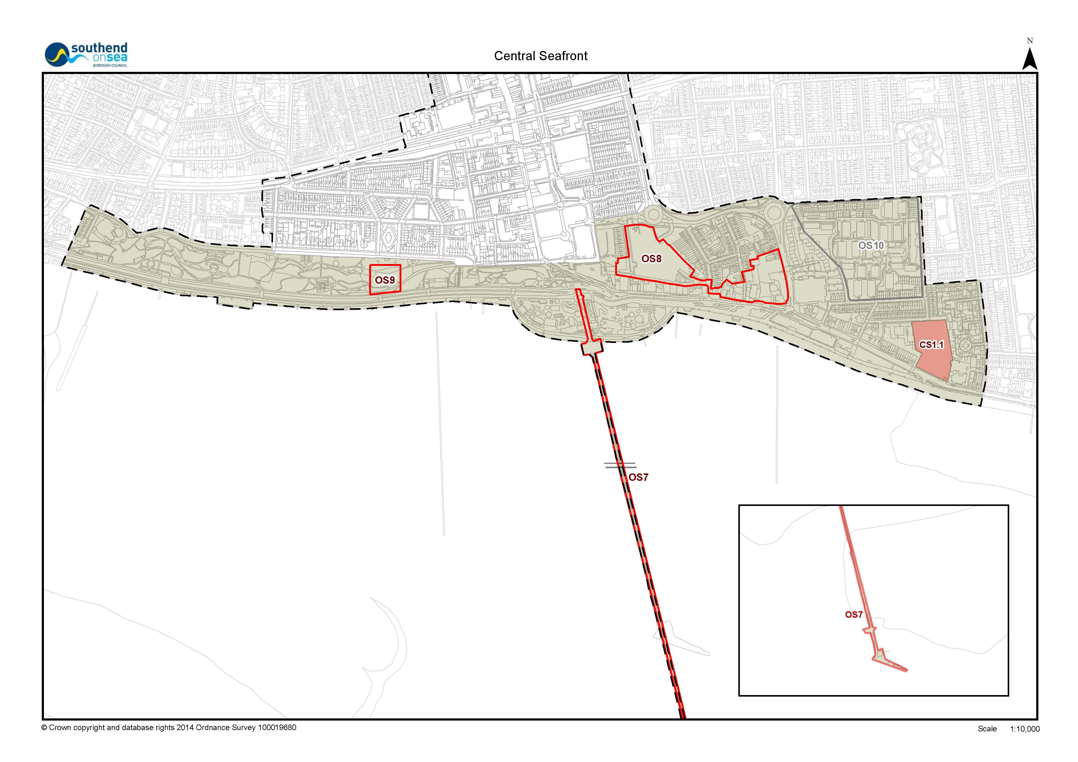
The Central Seafront will be a thriving and vibrant leisure, cultural and tourism area centred on the Grade II listed Pier which will be rejuvenated as an iconic landmark.
High quality mixed use schemes will be developed and heritage and natural assets conserved and enhanced. Innovative schemes such as 'Spanish steps,' providing enhanced pedestrian links, a seafront lido and a new world class museum will be promoted.
There will be seamless transition between the Central Seafront and the town centre. New and enhanced access points will create a network of routes that lead seamlessly to the estuary and foreshore from surrounding areas. This will increase permeability and encourage better functional links between the different policy areas, increasing footfall and opportunities to contribute towards the local economy.
Public realm improvements will be complemented by the placement of well-designed functional and creative lighting schemes and public art, which will visually enrich the area at night. The City Beach public realm scheme will be seamlessly extended facilitating improvements to Eastern Esplanade.
184 The Central Seafront Policy Area, as defined on the Policies Map, encompasses a number of environmental designations, SSSI, SPA and Ramsar site. These designations highlight the estuary's importance as a wildlife habitat. The policy approach to Nature Conservation and Biodiversity is set out within Policy CS2.
185 While the estuary provides an important habitat for birds and wildlife, it has attracted many visitors. As such the area is under pressure from a number of competing influences. There is a need to strike a balance between the protection and conservation of natural and built assets with the needs of residents and visitors utilising these resources, and the regeneration ambitions for the wider Southend Central Area.
186 The Grade II listed Pier, the longest pleasure Pier in the world, has recently benefitted from considerable investment, including the development of the Royal Pavilion and the Council will seek further opportunities for its enhancement.
187 The Central Seafront draws in residents and visitors for a range of activities. Adventure Island is a major tourism asset to Southend but its physical form tends to be inward looking and isolated from its urban context. It also obscures esplanade level views and routes to the sea. If redevelopment and expansion does occur options should be explored with the owner about how changes within the site could simultaneously benefit the public realm by creating a more permeable boundary and incorporating active frontages to increase footfall around the site edges
188 There has always been a physical separation of the Central Seafront Policy Area and Town Centre. If access was more straightforward and more pronounced there may be a better exchange of visitors between the Central Seafront and Town Centre and their functions.
Managing Flood Risk and Sustainable Drainage in the Central Seafront Policy Area
189 The Central Seafront Policy Area is at risk of flooding from tidal and surface water flooding, including areas within the Environment Agency Flood Zones 3a (higher risk) and Flood Zone 2 (lower risk). Therefore, all development with the Central Seafront Policy Area, including within its Opportunity Sites, should have particular regard to Policy DS4 Flood Risk Management and Sustainable Drainage.
190 Opportunity Site 7: Southend Pier
Southend Pier (Opportunity Site 7) has the potential to be further rejuvenated as a landmark and destination, building on the success of recent developments such as The Royal Pavilion.
191 Opportunity Site 8: Seaways Car Park and Marine Parade
Seaway Car Park presents a major opportunity for mixed-use development, contributing to the leisure and cultural offer of Southend Central Area through the provision of uses such as restaurants and cinema as well as providing residential units, car parking, public open and green spaces, improved access and connectivity through the creation of 'Spanish Steps', linking this opportunity site to the promenade of Marine Parade.
192 The Marine Parade element of Opportunity Site 8 will include a large development area known as Marine Plaza. The site offers potential for residential development, with supporting commercial uses and quality public open spaces to reinforce the offer of the eastern end of Marine Parade. The site offers potential for taller and larger buildings, creating a quality landmark to secure the regeneration of this part of the seafront.
193Opportunity Site 9: New Southend Museum
A new museum within the cliff face will feature a range of displays from the collections of the Central Museum and Beecroft Gallery, including the internationally significant Saxon King find, in a new high quality iconic building for Southend. Other facilities will include a planetarium, collections store with associated curatorial facilities, a museum shop, café and restaurant.
194 The siting of the new building within the cliff face will minimise impact on the Clifftown Conservation Area, whilst improving accessibility between the Clifftown and Central Seafront Policy Areas, enabling good views of the estuary from the building and spaces around it.
195Opportunity Site 10: Woodgrange Drive (Kursaal) Estate
The Woodgrange Drive Estate, known locally as the "Kursaal Estate" would benefit greatly from regeneration and enhancement to address some of the issues which have arisen since its construction. Proposals to reconnect the site with the surrounding streets and provide an enhanced environment for residents including green and open space, encouraging walking and cycling and improving links with the town centre, will be welcomed.
- Consider favourably proposals which enhance or diversify the range of arts, culture, entertainment, tourism, leisure and recreational facilities, subject to an assessment of the scale, character, location and impact of the proposal on existing facilities and environmental designations, including protected green space;
- Promote the provision of high quality hotels, subject to satisfactory access and parking provision;
- Secure high quality and sustainable redevelopment of poor quality, vacant or underused sites and buildings to improve the local townscape, including provision of active ground floor frontages to add to the vibrancy and vitality of the streetscene;
- Ensure that all development proposals affecting all designated and non-designated heritage assets, including Conservation Areas, listed and locally listed buildings, conserve and enhance these buildings and their settings;
- Ensure that all future sea defences and flood mitigation measures integrate seamlessly with the public realm;
- Seek to maintain foreshore views by restricting development south of the sea wall;
- Not normally permit development south of the seawall;
- Promote energy efficiency, including opportunity for decentralised energy supply, and the retrofit of existing development in line with local policy;
- Require all development within the Central Seafront
Policy Area to
- have regard to Policy DS4 in order to manage and mitigate against flood risk;
- safeguard and where appropriate enhance the biodiversity importance of the foreshore and respect the European designations in line with Policy CS2: Nature Conservation and Biodiversity
- Promote the following access and public realm
improvements:
- Emphasise landmarks (Policy DS3), orientation points, views and vistas, and improve accessibility between the seafront and town centre;
- create a well-defined piazza area at the southern end of the High Street between The Royals, The Palace Hotel and Pier Hill and encourage new and existing uses to provide active frontages to face onto this space;
- preservation and integration of the open spaces of the seafront and foreshore with the 'green grid' to create a series of linked, functional green spaces to relieve pressure on the seafront;
- use creative lighting and public art to strengthen identity and connectivity;
- remove unnecessary street furniture and rationalise signage in accordance with the principles set out in the Council's Streetscape Manual SPD, with particular focus on public realm adjacent to listed and locally listed buildings and Conservation Areas, in particular around The Kursaal;
- provision of a permeable boundary to Adventure Island to provide views in and through the site;
- implement a rolling programme of improvements to the promenade and public spaces (further developing the City Beach scheme at Eastern Esplanade), using high quality co-ordinated materials which are durable and easy to maintain;
- junction improvements at Queensway/Seaway Car Park/Chancellor Road.
- pursue urban greening and provide additional seating, tree planting and landscaping, as well as enhanced links between neighbouring Policy Areas;
- upgrade the Cliffs Pavilion outdoor space and improve its connection to the Cliffs;
- improve traffic management, parking, and walking and cycling, including SUSTRANS route.
- improvements to the Sealife Centre through redesign or redevelopment;
- regeneration of redundant lavatories and the crazy golf site for kiosks or other small-scale seaside businesses;
- explore development of a Seafront lido to increase the leisure offer.
- There is potential for archaeological deposits within the area of the Southend Cliffs and Seaway Car Park. Developers should have regard to Policy DM5 - Southend-on-Sea's Historic Environment of the Development Management Document.
- The following site, as identified on the Policies Map,
is considered to be suitable primarily for residential use:
Site Reference
Site Name
Planning Status*
Indicative number of dwellings
Timescale for delivery
CS1.1
Esplanade House
NS
266
Pre 2021
*Planning Status as of April 2014. NS = Not Started with full planning permission.
- The following Opportunity Sites, as identified on the
Policies Map, are considered suitable for development for
mixed-use purposes within the Central Seafront Policy Area:
Site Reference
Site Name
Planning Status*
Indicative number of dwellings
Timescale for delivery
OS7
Southend Pier
NA
N/A
Pre 2021
OS8
Seaways and Marine Parade
NA
340
Pre 2021
OS9
New Southend Museum
NA
N/A
Pre 2021
*Planning Status as of April 2014. NA = New Allocation
i. Opportunity Site 7: Southend Pier, the Council will pursue with private sector partners and through other initiatives, sensitive redevelopment at both ends of the pier to provide a mix of cultural and leisure uses during the day and in the evening, including: uses such as cafes, restaurants, shops, events, heritage centre, and small scale moorings; deckchairs and telescopes; facilities for traditional activities such as angling; creative lighting; sensitively sited renewable technologies where appropriate.
ii. Opportunity Site 8: Seaway Car Park and Marine Parade, the Council will pursue with private sector partners, landowners and developers a high quality, mixed use development including the provision of leisure, cultural and tourism attractions including: restaurants, cinema, gallery, hotel, residential development, public and private open spaces, and car parking. This should be taken forward through the preparation of a development brief. Design and layout solutions should allow for:
- a remodelling of the urban form to create a north-south axis on the Seaway site, providing a clear sight-line from Queensway dual carriageway to the sea;
- a stronger relationship with the Town Centre through the provision of safe and legible pedestrian and cycle routes;
- explore opportunities for a new link to Marine Parade from the Seaway site designed around 'Spanish Steps'; active frontages to all new and existing streets and spaces; appropriately sited taller and larger buildings to take advantage of estuary views (particularly to the Marine Parade part of the site), provided they do not cause undue overshadowing and are not detrimental to the amenity of existing uses;
- a palette of good quality materials to reflect the vibrancy and colour of the seaside;
- relocation of the coach-drop off point following the development of the Seaway site.
- urban greening projects, including the creation of new public and private green space within new development;
- innovative design which allows the site to take advantage of the elevation and creates a legible environment with views of the estuary.
iii. Opportunity Site 9: New Southend Museum, the Council will promote the development of an exemplary, sustainable building that includes the new Southend Museum, gallery space, planetarium, conference/events spaces, and associated café/restaurant, together with public car parking and the creation of high quality green space (including amphitheatre) within the Cliffs, linked to the High Street and Central Seafront via Cliff Gardens, Prittlewell Square and the wider Clifftown Policy Area. The design of new development will need to retain the open feel of this area and ensure that new planting includes native species, increasing biodiversity in the area.
The following site is expected to be delivered in the period after 2021, which is beyond the plan period for the SCAAP. Nevertheless, it is presented here to allow for further evidence to be submitted that can demonstrate that it is deliverable by 2021 and therefore should be allocated within the SCAAP. If it is not shown to be deliverable by 2021 then it will be included within the preparation of the new Southend Local Plan in accordance with the Local Development Scheme:
- 14.The following Opportunity Site, as identified on the
Policies Map, is considered suitable primarily for
residential development and potential for office and
supporting community uses
Site Reference
Site Name
Planning Status*
Indicative number of dwellings
Timescale for delivery
OS10
Woodgrange
NA
N/A
Post 2021
*Planning Status as of April 2014. NA = New Allocation
i. Opportunity Site 10: Woodgrange Drive (Kursaal) Estate, the Council will support proposals by public sector partners to regenerate and enhance the site for housing, including social housing, by using solutions to re-integrate it with the existing surrounding residential area. Development should enhance the legibility and accessibility of the Estate through the use of way-finding signage, improved pedestrian and cycle links to the seafront and town centre. This should be taken forward through the preparation of a development brief.
If you consider that the timescale for delivering OS7, OS8, OS9 and CS1.1 should be different then please provide evidence to support a revised timeframe.
|
Core Strategy DPD Objectives Strategic Objective 4 Strategic Objective 6 Strategic Objective 7 Strategic Objective 9 Strategic Objective 10 Strategic Objective 12 Strategic Objective 14 Strategic Objective 15 Strategic Objective 17 Strategic Objective 18 |
Policies KP1: Spatial Strategy KP2: Development Principles KP3: Implementation and Resources CP3: Transport and Accessibility CP4: The Environment and Urban Renaissance CP7 - Sport, Recreation and Green Space CP 8: Dwelling Provision |
|
Development Management DPD |
Policies DM1: Design Quality DM2: Low Carbon and Development and Efficient Use of Resources DM3: Efficient and Effective Use of Land DM4: Tall and Large Buildings DM5: Southend-on-Sea's Historic Environment DM6: The Seafront DM7: Dwelling Mix, Size and Type DM8: Residential Standards DM9: Specialist Residential Accommodation DM10: Employment Sectors DM12: Visitor Accommodation DM14: Environmental Protection DM15: Sustainable Transport Management |
|
Southend Central AAP Objectives Objective 1 Objective 2 Objective 3 Objective 4 Objective 5 Objective 6 Objective 7 Objective 8 Objective 10 |
Policies DS2: Key Views DS3: Landmark and Landmark Buildings DS4:Flood Risk Management and Sustainable Drainage DS5: Transport, Access and Public Realm PA1: High Street Policy Area Development Principles PA6: Clifftown Policy Area Development Principle PA7: Tylers Policy Area Development Principles CS2:Nature Conservation and Biodiversity CS3: The Waterfront |
*This Policy Linkage Box provides a summary of key inter-related local policies. Other planning policy and guidance not listed here may also be applicable and, therefore, a full assessment should be undertaken.
The policy approach to the management of development within the Central Seafront Policy Area has been reviewed in the context of current guidance and evidence. Subsequently, the proposed approach and previous policies have been rationalised and incorporated into this Policy to avoid duplication and in order to keep the plan concise and effective. These previous polices, as set out in the 2011 version of the SCAAP, include CS2 - Central Seafront Strategy Key Principles; CS6 - Central Seafront Development Principles; CS7 - Western Esplanade the Cliffs and Shrubbery; CS8 Eastern Esplanade and City Beach Gateway.
The previous iterations of the SCAAP referred to Quarters, Gateway Neighbourhoods and Proposal Sites. Following a review of the Plan, these terms have been revised and Quarters and Gateway Neighbourhoods are referred to within the Preferred Approach version of the SCAAP as 'Policy Areas', and Proposal Sites as 'Opportunity Sites'. Policy criterion relating to Opportunity Sites has now been incorporated into the development principles of the Policy Area.
This should be read in conjunction with the criteria based policies in the development strategy section within this Plan, together with relevant Policy Areas and Opportunity Sites and relevant policies within the Core Strategy and Development Management Document.
- National Planning Policy Framework and Guidance
- Central Area Masterplan (2008)
- SCAAP Issues and Options version (2010)
- SCAAP (superseded) Proposed Submission version (2011)
- Consultation Statements, responding to comments made on previous versions of the SCAAP
- Sustainability Appraisal, HRA and EQIA
- Southend Borough Wide Character Study (2011)
- Design and Townscape Guide SPD1 (2009)
- Southend Streetscape Manual SPD3 (2015)
- Strategic Housing Land Availability Assessment, and updates (2010, 2013)
- Strategic Housing Market Assessment (2013)
- Annual Monitoring Reports
This list is not exhaustive. Full evidence base is available on the Council's website.
Nature Conservation and Biodiversity in the Central Seafront Policy Area
196 The foreshore is designated as International and European sites for nature conservation. Particularly relevant to the Central Seafront Policy Area are Benfleet and Southend Marshes (SPA, SSSI and Ramsar site), which comprises the intertidal part of the Thames Estuary from Benfleet to Shoeburyness and covers the same land area within the SCAAP and wider Southend-on-Sea borough.
197 The marshes also provide an attractive environment for both marine activities and more passive enjoyment of natural habitats. There may be opportunities to design high quality visitor facilities, giving visitors a better understanding of the ecosystems. All future activity and development will need to ensure that they do not adversely affect the interests of the nature conservation designations on the foreshore.
198 Developments which may affect a site of International or European nature conservation importance (SPA, Ramsar) will be subject to rigorous examination in consultation with Natural England and other relevant authorities.
199 Even if a development is located some distance from an International or European site they may still have a detrimental impact on the site and will need to be subject to a Habitats Regulations Assessment. Natural England should be consulted at an early stage of a planning application.
200 The applicant must submit appropriate biodiversity surveys, impact assessment and mitigation proposals to enable the Council to determine a planning application in addition to habitat regulation assessment, where required.
201 If it cannot be demonstrated that the application will not adversely affect an International or European site, then the application will be refused, unless there are no alternative solutions and the development has to be carried out for imperative reasons of over-riding public interest as set out in the Habitats Regulations.
202 In such cases compensatory habitat will be required. In addition, the Council will consider applying planning conditions or legal obligations to secure the integrity of the international or European site from any adverse impacts arising from the development.
- Ensure that all development proposals within the Central Seafront Area are accompanied by a Habitats Regulations Assessment and associated documentation to guarantee that the International and European foreshore designations (SSSI, Ramsar and SPA) are respected and that there is no negative impact on them;
- Not permit development proposals that will have an adverse impact, either directly or indirectly, on the foreshore designations;
- In exceptional circumstances make exceptions on a Site
of Special Scientific Interest (SSSI), only if it can be
demonstrated that:
- there are no alternative solutions; and
- the reasons for the development clearly outweigh the nature conservation value of the site and is in the public interest,
- Apply planning conditions or legal obligations to secure the protection, conservation and enhancement of a Site of Special Scientific Interest (SSSI) from any harmful impacts arising from the development;
- Integrate the seafront and foreshore open space within a broader Southend 'green grid' of linked and functional green space to relieve visitor pressure on the seafront, and protect the sensitivities of the biodiversity interest. Areas of new/ improved public open space will be particularly promoted at Pier Hill, Seaway Car Park and along Eastern Esplanade;
- Consider favourably the development of a high quality visitor facility close to the foreshore which interprets the natural habitat in the area providing visitors a better understanding of the ecosystems and biodiversity.
|
Core Strategy DPD Objectives Strategic Objective 12 Strategic Objective 18 |
Policies KP1: Spatial Strategy KP2: Development Principles KP3: Implementation and Resources CP4: The Environment and Urban Renaissance CP7 - Sport, Recreation and Green Space |
|
Development Management DPD |
Policies DM6: The Seafront |
|
Southend Central AAP Objectives Objective 3 Objective 5 Objective 6 |
Policies DS4:Flood Risk Management and Sustainable Drainage DS5: Transport, Access and Public Realm CS1: Central Seafront Policy Area Development Principles CS3: The Waterfront |
*This Policy Linkage Box provides a summary of key inter-related local policies. Other planning policy and guidance not listed here may also be applicable and, therefore, a full assessment should be undertaken.
The policy approach to the management of development within the Central Seafront Policy Area has been reviewed in the context of current guidance and evidence. There is no material change to the previous policy CS4 - Nature Conservation and Biodiversity that was presented in the 2011 version of the SCAAP.
- National Planning Policy Framework and Guidance
- Central Area Masterplan (2008)
- SCAAP Issues and Options version (2010)
- SCAAP (superseded) Proposed Submission version (2011)
- Consultation Statements, responding to comments made on previous versions of the SCAAP
- Sustainability Appraisal, HRA and EQIA
This list is not exhaustive. Full evidence base is available on the Council's website.
203 The Council will promote the waterfront for a wide range of sport, recreation and leisure activities, whilst also respecting the natural environment as outlined in Policy CS2.
204 Improving marine activity facilities will encourage more water based activities, users and visitors, and cater for leisure demand and tourism. Jetties, moorings and support facilities are vital components of an active and attractive waterfront. The Council will promote the beaches, foreshore and estuary for boat users, including through the maintenance and enhancement of existing facilities. There is opportunity to build on the success of water based sports and recreation in other seafront locations in the Borough and beyond to further broaden its offer within the Central Seafront Policy Area.
205 The provision of information and interpretation boards and other information-based facilities about the waterfront and wildlife, will be encouraged.
- The Council, with private sector partners and through
the exercise of its planning powers and other initiatives
will:
- promote the beach, foreshore and Estuary for
appropriate cultural, leisure and tourism activities,
including the maintenance and enhancement of facilities
for:
i. seafront, beach and water-based recreation activities and attractions including tidal paddling pools;
ii. marine and boat users, including moorings, support facilities (wharfs, jetties, landing stages and slipways), club facilities and information.
- continue to maintain the quality and cleanliness of
the beach and foreshore experience, including:
i. pursuing a rolling programme of co-ordinated public realm improvements to the promenade;
ii. integrating the protection and interpretation of biodiversity interests, heritage assets and landscape features, including views across the Estuary, into the overall visitor experience through:
01. provision of information boards/facilities including making increasing use of mobile phone and digital technology;
02. themed walking and cycling signed routes, and links to a broader borough wide network.
- promote the beach, foreshore and Estuary for
appropriate cultural, leisure and tourism activities,
including the maintenance and enhancement of facilities
for:
- Proposals for waterfront development within the Central Seafront Area and improved facilities will need to demonstrate that there will be no unacceptable impact upon navigation, biodiversity, flood risk or the special character and designations.
|
Core Strategy DPD Objectives Strategic Objective 12 Strategic Objective 18 |
Policies KP1: Spatial Strategy KP2: Development Principles KP3: Implementation and Resources CP4: The Environment and Urban Renaissance CP7 - Sport, Recreation and Green Space |
|
Development Management DPD |
Policies DM6: The Seafront |
|
Southend Central AAP Objectives Objective 3 Objective 5 Objective 6 |
Policies DS4:Flood Risk Management and Sustainable Drainage DS5: Transport, Access and Public Realm CS1: Central Seafront Policy Area Development Principles CS2:Nature Conservation and Biodiversity |
*This Policy Linkage Box provides a summary of key inter-related local policies. Other planning policy and guidance not listed here may also be applicable and, therefore, a full assessment should be undertaken.
The policy approach to the management of development within the Central Seafront Policy Area has been reviewed in the context of current guidance and evidence. There have been some minor amendments to the previous policy CS5 - The Waterfront, to avoid duplication of matters that are addressed elsewhere in the document.
- National Planning Policy Framework and Guidance
- Central Area Masterplan (2008)
- SCAAP Issues and Options version (2010)
- SCAAP (superseded) Proposed Submission version (2011)
- Consultation Statements, responding to comments made on previous versions of the SCAAP
- Sustainability Appraisal, HRA and EQIA
This list is not exhaustive. Full evidence base is available on the Council's website.
5.10 The Victoria Gateway Neighbourhood Policy Area
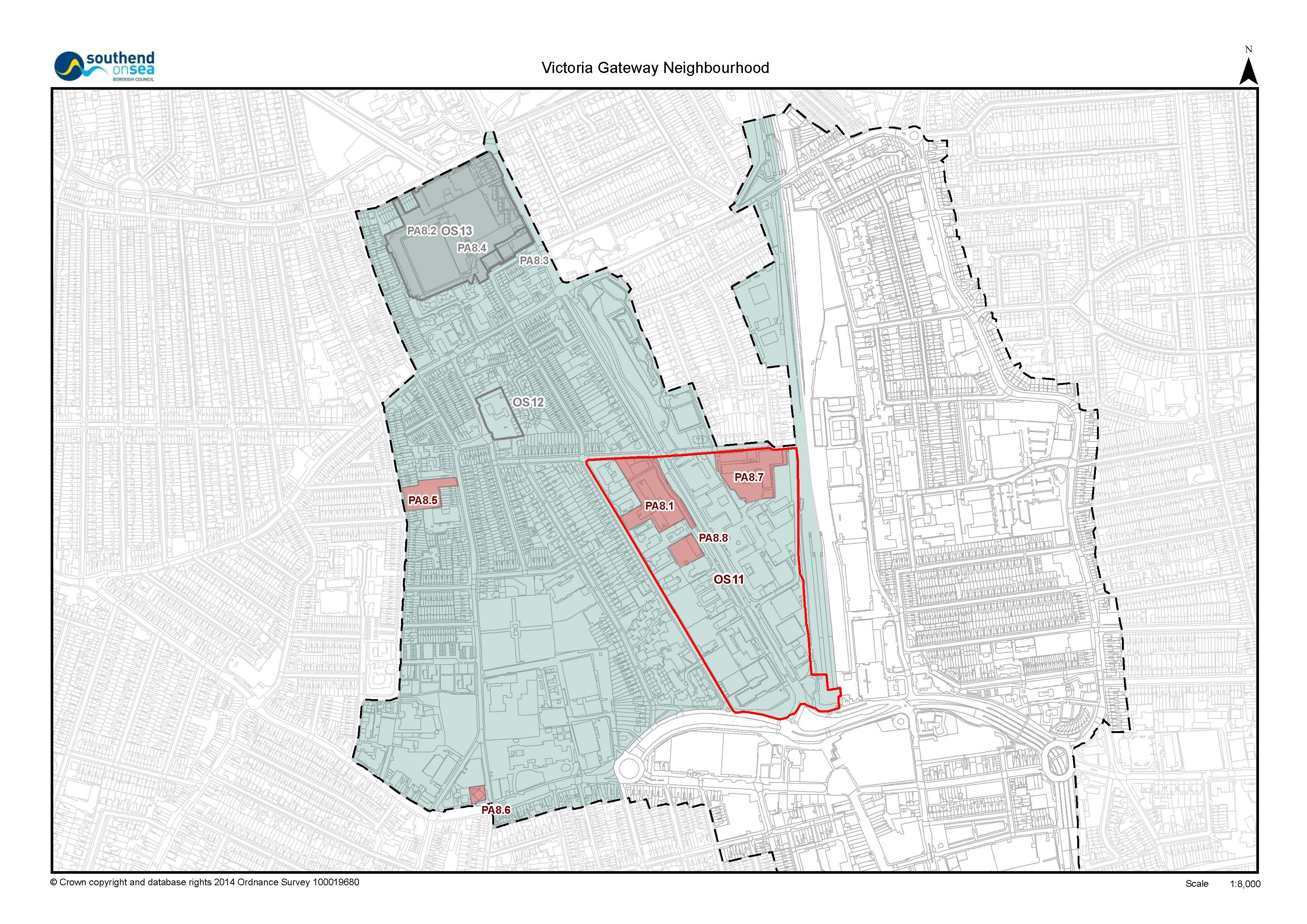
A regenerated Victoria Avenue will form an attractive and vibrant gateway to the town centre, enhanced by future phases of the Victoria Gateway scheme which will see improved connections and accessibility. New development will be of a high standard of design, with urban greening techniques, pocket parks, community gardens, tree planting and landscaping, together with a consistent palette of surface materials and street furniture.
Victoria Avenue will be an attractive area in which to live, where residents will benefit from the sustainability of the location. Enhancements to the public realm will be undertaken throughout the neighbourhood, to encourage walking and cycling and improve access to the town centre, employment area and public transport interchanges.
The heritage of Prittlewell Conservation Area will be celebrated and the character of the area will be reinforced by sensitively restored buildings that positively contribute to a distinctive sense of place. Buildings will be set within a quality public realm, with improved access to information about the area's history.
The neighbourhood will benefit from a thriving niche local shopping centre on West Street.
206 There are three Opportunity Sites within the Victoria Gateway Neighbourhood Policy Area, as defined on the Policies Map.
207 The Policy Area is home to Southend's traditional office area at Victoria Avenue (Opportunity Site 11), which includes the civic quarter. The significant challenge for this neighbourhood is to address the large amount of underused, vacant and outmoded office buildings. Some have received prior approval to residential through recently changed permitted development rights, but others still provide opportunity for more comprehensive development.
208 Prittlewell Conservation Area to the north and the buildings, structures and spaces within it are important heritage assets, forming a key gateway on the main route into the Town Centre along Victoria Avenue. This Conservation Area contains some of the Town's oldest and most important buildings.
209 Southend United Football Club have an ambition to relocate their stadium creating an opportunity to redevelop a large area for a mixed use development (Opportunity Site 13). Redevelopment of the existing stadium is not permitted at this site until a Fossetts Farm scheme is fully functioning as a replacement football stadium.
210 The Former Essex and Suffolk Water Board Site is currently occupied by artist's studios, exhibition space and screening rooms. Cultural uses on the site will continue to be supported. To complement this, the site has potential to develop live-work units and some residential.
211 The Neighbourhood contains a local shopping centre at West Street, designated as secondary shopping frontage, which provides an important resource for local residents and businesses, and as the Neighbourhood regenerates it is anticipated that this centre will continue to support the needs of the local population.
212 Some areas within this Policy Area are susceptible to surface water flooding. Therefore, development will need to have regard to local flood risk management policies, particularly regarding SuDS as set out in Policy DS4.
- Look favourably on developments and schemes which can demonstrate that they will contribute to the transformation of this area to provide for a vibrant community, which is integrated with the surrounding neighbourhood and set within a remodelled built form of a quality that benefits this key gateway to the Town Centre,
- Ensure all development within Prittlewell Conservation Area seeks to conserve and enhance the heritage assets and repair gaps in the frontage along Victoria Avenue, realising the potential of the backland area to the rear of Victoria Avenue (west side 255-289) as a 'Lanes' style development, promoting specialist and independent industries, associated small scale businesses and ancillary residential units;
- Give consideration to the provision of additional education facilities within the Neighbourhood based on an assessment of the expansion needs when and where appropriate development opportunities arise;
- Promote energy efficiency, including opportunity for decentralised energy supply, and the retrofit of existing development in line with local policy
- Use its enforcement powers to reduce the damage to amenities and the environment resulting from long term vacant and derelict land and buildings.
- Promote the provision of easily accessible new social and community infrastructure, such as doctor and dental surgeries, nurseries and community hubs.
- Ensure that housing development including, mix and tenure is delivered in line with Development Management Policy DM7 - Dwelling Mix, Size and Type.
- promote the following access and public realm
improvements:
- a priority route linking Southend Central Area with London Southend Airport and adjacent development areas, including improvements at the junctions between the A127 at Fairfax Drive and East Street;
- appropriate enhancements to North Road, including civic space at junction with Chelmsford Avenue, to improve the residential environment, provide for walking and cycling, and improve linkages to West Street local shopping centre, cultural facilities at Opportunity Site 12 and Prittlewell Chapel;
- public realm improvements to the Victoria Avenue service road in association with development proposals within Opportunity Site 11;
- full integration with surrounding area through the provision of pedestrian and cycling routes, to improve access and linkages;
- urban greening projects linked to the green grid, including planting and the creation of new public and private green space within new development;
- enhancement of the existing Civic Space (including the Holocaust Memorial) on the east side of Victoria Avenue between the Civic Centre and Law Courts, and its integration with the broader area.
- contribute to improvements to the Victoria Avenue / East Street / West Street junction to reduce the visual impact of traffic (and associated street furniture) on the Prittlewell Conservation Area, reduce street clutter, and provide an enhanced public realm complemented by soft landscaping and planting.
- There is potential for archaeological deposits within the area of Nazareth House and Roots Hall and as such developers should have regard to Policy DM5 - Southend-on-Sea's Historic Environment.
- The following sites, as identified on the Policies Map,
are considered to be suitable primarily for residential
development:
Site Reference
Site Name
Planning Status*
Indicative number of dwellings
Timescale for delivery
PA8.1
Heath House And Carby House
NS
280
Pre 2021
PA8.5
Salisbury Avenue & North Rd
NS
43
Pre 2021
PA8.6
175 London Road
NS
27
Pre 2021
PA8.7
Carnarvon Road
NS
131
Pre 2021
PA8.8
Victoria House
NS
40
Pre 2021
*Planning Status as of April 2014. NS = Not Started with full planning permission.
- The following Opportunity Site, as identified on the
Policies Map, is considered suitable for mixed-use
development, comprising residential, office, convenience
retail, leisure, cafes and community uses:
Site Reference
Site Name
Planning Status*
Indicative number of dwellings
Timescale for delivery
OS11
Victoria Avenue
NA
1084
Pre 2021
*Planning Status as of April 2014. NA = New Allocation (some areas within OS11 with planning permission [PA8.1, PA8.7 and PA8.8])
i. Within Opportunity Site 11: Victoria Avenue Office Area, planning permission will be granted for comprehensive redevelopment of this site, or incremental development within the area, to transform it into a sustainable mixed use community, including:
(a) an acceptable mix of uses focussed on residential uses to upper floors and small scale flexible office accommodation complimented by local convenience retail uses, leisure (cafes and bars) and community facilities to ground floors
(b) full integration with surrounding area through the provision of pedestrian and cycling routes, to improve access and linkages
(c) limited strategic locations for taller buildings
(d) Urban greening projects, including:
01. - the use of green walls and roof gardens;
02. - comprehensive landscaping;
03. - the creation of a series of linked public green space within the area linked to a wider network of parks and gardens;
04. - a comprehensive sustainable drainage system.
(e) pursue, as appropriate, a full range of measures to enable delivery of the site, including Compulsory Purchase powers, preparation of a Development Brief to guide comprehensive redevelopment, partnership working with private sector landowners and developers.
(f) In the event of incremental redevelopment of individual sites, the Council will require each development site to demonstrate how it meets the policy criteria and development principles set out above and accords with any future development brief related to the opportunity site.
The following sites are expected to be delivered in the period after 2021, which is beyond the plan period for the SCAAP. Nevertheless, it is presented here to allow for further evidence to be submitted that can demonstrate that it is deliverable by 2021 and therefore should be allocated within the SCAAP. If they are not shown to be deliverable by 2021 then they will be included within the preparation of the new Southend Local Plan in accordance with the Local Development Scheme:
- The following sites, as identified on the Policies Map,
are considered suitable for new development and
regeneration:
Site Reference
Site Name
Planning Status*
Indicative number of dwellings
Timescale for delivery
OS12
Water Board Site
NA
30
Post 2021
OS13
Roots Hall
NS
290
Post 2021
PA8.2
Roots Hall Stadium
NS
272
Post 2021
PA8.3
297 Victoria Avenue
NS
30
Post 2021
PA8.4
25 Roots Hall Avenue
NS
18
Post 2021
*Planning Status as of April 2014. NA = New Allocation. NS = Not Started with full planning permission.
i. Within Opportunity Site 12: Former Essex and Suffolk Water Board Site, the Council will seek to promote and enhance cultural facilities and creative industries, building on the current use and capitalising on the merits of the existing building. The Council will also support in principle the potential for live-work units and some other residential.
ii. Within Opportunity Site 13: Roots Hall Football Ground and Environs, in the event of Southend United Football Club relocating their stadium, the Council will support a mixed use scheme with quality, usable amenity space, and good quality landscaping.
If you consider that the timescale for delivering the proposed sites should be different then please provide evidence to support a revised timeframe.
|
Core Strategy DPD Objectives Strategic Objective 1 Strategic Objective 2 Strategic Objective 3 Strategic Objective 4 Strategic Objective 5 Strategic Objective 6 Strategic Objective 7 Strategic Objective 9 Strategic Objective 10 Strategic Objective 11 Strategic Objective 13 Strategic Objective 14 Strategic Objective 15 Strategic Objective 18 |
Policies KP1: Spatial Strategy KP2: Development Principles KP3: Implementation and Resources CP1: Employment Generating Development CP3: Transport and Accessibility CP4: The Environment and Urban Renaissance CP6: Community infrastructure CP7 - Sport, Recreation and Green Space CP 8: Dwelling Provision |
|
Development Management DPD |
Policies DM1: Design Quality DM2: Low Carbon and Development and Efficient Use of Resources DM3: Efficient and Effective Use of Land DM4: Tall and Large Buildings DM5: Southend-on-Sea's Historic Environment DM7: Dwelling Mix, Size and Type DM8: Residential Standards DM9: Specialist Residential Accommodation DM10: Employment Sectors DM13: Shopping Frontage Management outside the Town Centre DM15: Sustainable Transport Management |
|
Southend Central AAP Objectives Objective 1 Objective 2 Objective 3 Objective 4 Objective 5 Objective 6 Objective 7 Objective 8 Objective 9 Objective 10 |
Policies DS2: Key Views DS3: Landmark and Landmark Buildings DS4:Flood Risk Management and Sustainable Drainage DS5: Transport, Access and Public Realm PA1: High Street Policy Area Development Principles PA2: London Road Policy Area Development Principles PA9: Sutton Gateway Neighbourhood Policy Area Development Principles |
*This Policy Linkage Box provides a summary of key inter-related local policies. Other planning policy and guidance not listed here may also be applicable and, therefore, a full assessment should be undertaken.
The policy approach to the management of development within the Victoria Gateway Neighbourhood Policy Area has been reviewed in the context of current guidance and evidence.
Within the 2011 Proposed Submission version of the Plan, Policy PA8 was referred to as Policy DP8: Victoria Gateway Neighbourhood Policy Area Development Principles. There have been some minor amendments to the previous Policy DP9, to avoid duplication of matters that are addressed elsewhere in the document.
The previous iterations of the SCAAP referred to Quarters, Gateway Neighbourhoods and Proposal Sites. Following a review of the Plan, these terms have been revised and Quarters and Gateway Neighbourhoods are referred to within the Preferred Approach version of the SCAAP as 'Policy Areas', and Proposal Sites as 'Opportunity Sites'. Policy criterion relating to Opportunity Sites has now been incorporated into the development principles of the Policy Area.
This should be read in conjunction with the criteria based policies in the development strategy section within this Plan, together with relevant Policy Areas and Opportunity Sites and relevant policies within the Core Strategy and Development Management Document.
- National Planning Policy Framework and Guidance
- Central Area Masterplan (2008)
- SCAAP Issues and Options version (2010)
- SCAAP (superseded) Proposed Submission version (2011)
- Consultation Statements, responding to comments made on previous versions of the SCAAP
- Sustainability Appraisal, HRA and EQIA
- Strategic Housing Land Availability Assessment, and updates (2010, 2013)
- Strategic Housing Market Assessment (2013)
- Annual Monitoring Reports
This list is not exhaustive. Full evidence base is available on the Council's website.
5.11 Sutton Gateway Neighbourhood Policy Area
The Sutton Gateway will be regenerated, with high quality, sustainable buildings helping to restore the built fabric, creating a distinctive sense of place where people are proud to live and work. It will be supported by a thriving local shopping centre on Sutton Road.
This will be achieved by repairing, unifying and knitting together the townscape to create a cohesive neighbourhood that retains a variety of uses, which relate well to each other.
The policy area will provide employment opportunities, protecting, maintaining and promoting Grainger Road and Short Street Employment Growth Areas as locations for increased employment floorspace.
The area will be easily accessible by foot and by bike, with improved links between residential areas, the town centre, public transport nodes, retail and employments areas.
213 The Sutton Gateway Neighbourhood Policy Area is defined on the Policies Map. It contains a diverse mix of uses including: residential, employment areas and a retail park. The southern section of Sutton Road comprises a local shopping centre with a mix of retail uses and services for the local community.
214 The SCAAP aims to maintain and reinforce the existing local shopping centre and in design terms repair, unify and knit together the townscape to create a better neighbourhood that retains a variety of uses but where these uses relate better to each other.
215 There is also scope to maintain and promote Grainger Road and Short Street Employment Growth Areas as locations for increased employment floorspace through a managed approach using development briefs as appropriate that will set out the quantum of development and appropriate uses. Refer to Development Management Document Policy DM11 - Employment Areas.
216 Clearly access to and within this neighbourhood and to the Town Centre and public transport facilities are important and there are opportunities to improve the environment of Short Street along its length, including continuing the footway north. Sutton Road is also a major multimodal route and environmental improvements here would support the local shopping centre.
217 The Opportunity Site: Sutton Road (OS14) is considered suitable for redevelopment for additional housing alongside an appropriate level of supporting uses, such as community uses. Currently it contains a number of buildings, primarily in employment use, that front Sutton Road. In recent years change has slowly begun to take place, transforming the area to a residential-led community.
218 The former B&Q site is now occupied with a long term lease. However, given the prominence of the site if a redevelopment opportunity was to come forward, a development brief should be prepared and agreed with the Council to guide proposals. There may be potential for this site to integrate with development in adjoining Policy Area's, particularly Queensway Policy Area if the opportunity arose.
- Maintain and promote Grainger Road and Short Street Employment Growth Areas as locations for increased employment floorspace in line with Development Management Policy DM11 - Employment Areas;
- Promote energy efficiency, including opportunity for decentralised energy supply, and the retrofit of existing development in line with local policy
- In the event of redevelopment of the former B&Q site a development brief will be produced to guide development.
- Consider the provision of additional education facilities based on an assessment of the expansion needs when and where appropriate development opportunities arise;
- Promote the following access and public realm
improvements:
- appropriate enhancements to Sutton Road to uplift the residential environment and enhance provisions for walking and cycling;
- an enhanced cycling and pedestrian route along the length of Short Street, enhancing connections between East Street and Queensway dual carriage way;
- streetscape and landscape design improvements, including urban greening and tree planting
- The following sites, as identified on the Policies Map,
are considered to be suitable primarily for residential
use:
Site Reference
Site Name
Planning Status*
Indicative number of dwellings
Timescale for delivery
PA9.1
Kenway
NS
45
Pre 2021
PA9.2
257 - 285 Sutton Road
NS
97
Pre 2021
PA9.3
319 - 321 Sutton Road
NS
32
Pre 2021
*Planning Status as of April 2014. NS = Not Started with full planning permission.
- The following Opportunity Site, as identified on the
Policies Map, is considered suitable for residential and
community uses:
Site Reference
Site Name
Planning Status*
Indicative number of dwellings
Timescale for delivery
OS14
Sutton Road
NA
254
Pre 2021
*Planning Status as of April 2014. NA = New Allocation (some areas within OS14 with planning permission [PA9.2, PA9.3])
i. Within Opportunity Site 14: Sutton Road, the Council will support the redevelopment of this area for high quality housing and community facilities. This could be through the preparation of a development. The Council will require the building design, form and massing to:
- Have regard to residential buildings on the opposite side of Sutton Road and contribute positively to repairing the street scene and urban grain in this area;
- Provide for a new area of public open space linked to the wider green grid;
- Include enhancements to the public realm to create a coordinated, sustainable palette of materials and furniture in accordance with the Streetscape Manual SPD3.
If you consider that the timescale for delivering OS14, PA9.1, PA9.2 and PA9.3 should be different then please provide evidence to support a revised timeframe.
|
Core Strategy DPD Objectives Strategic Objective 2 Strategic Objective 3 Strategic Objective 4 Strategic Objective 5 Strategic Objective 6 Strategic Objective 7 Strategic Objective 9 Strategic Objective 13 Strategic Objective 14 Strategic Objective 15 Strategic Objective 17 Strategic Objective 18 |
Policies KP1: Spatial Strategy KP2: Development Principles KP3: Implementation and Resources CP1: Employment Generating Development CP3: Transport and Accessibility CP4: The Environment and Urban Renaissance CP6: Community infrastructure CP7: Sport, Recreation and Green Space CP 8: Dwelling Provision |
|
Development Management DPD |
Policies DM1: Design Quality DM2: Low Carbon and Development and Efficient Use of Resources DM3: Efficient and Effective Use of Land DM4: Tall and Large Buildings DM7: Dwelling Mix, Size and Type DM8: Residential Standards DM9: Specialist Residential Accommodation DM10: Employment Sectors DM11: Employment Areas DM13: Shopping Frontage Management outside the Town Centre DM14: Environmental Protection DM15: Sustainable Transport Management |
|
Southend Central AAP Objectives Objective 1 Objective 2 Objective 3 Objective 5 Objective 6 Objective 8 Objective 9 Objective 10 |
Policies DS4:Flood Risk Management and Sustainable Drainage DS5: Transport, Access and Public Realm PA2: London Road Policy Area Development Principles PA4: Queensway Policy Area Development Principles PA8: Victoria Gateway Neighbourhood Policy Area Development Principles |
*This Policy Linkage Box provides a summary of key inter-related local policies. Other planning policy and guidance not listed here may also be applicable and, therefore, a full assessment should be undertaken.
The policy approach to the management of development within the Sutton Road Neighbourhood Policy Area has been reviewed in the context of current guidance and evidence.
Within the 2011 Proposed Submission version of the Plan, Policy PA9 was referred to as Policy DP9: Sutton Gateway Neighbourhood Policy Area Development Principles. The previous iterations of the SCAAP referred to Quarters, Gateway Neighbourhoods and Proposal Sites. Following a review of the Plan, these terms have been revised and Quarters and Gateway Neighbourhoods are referred to within the Preferred Approach version of the SCAAP as 'Policy Areas', and Proposal Sites as 'Opportunity Sites'. Policy criterion relating to Opportunity Sites has now been incorporated into the development principles of the Policy Area.
It has been determined that the site allocation from the 2011 Proposed Submission version of the SCAAP (formerly referred to as Proposal Site Policy PS10a: Former B&Q site) should be removed. In the event of the redevelopment of this site a development brief to be bought forward to guide redevelopment.
Additionally, previous Proposal Site PS10c: Coleman Street has been incorporated into PA4: Queensway Policy Area and Opportunity Site 4: Queensway.
It is considered that the policy approach is appropriate and effective. This should be read in conjunction with the criteria based policies in the development strategy section within this Plan, together with relevant Policy Areas and Opportunity Sites and relevant policies within the Core Strategy and Development Management Document.
The SHLAA and ELR identified that there was scope to reinforce local employment opportunities in the Neighbourhood whilst at the same time developing opportunities for additional housing.
- National Planning Policy Framework and Guidance
- Central Area Masterplan (2008)
- SCAAP Issues and Options version (2010)
- SCAAP (superseded) Proposed Submission version (2011)
- Consultation Statements, responding to comments made on previous versions of the SCAAP
- Sustainability Appraisal, HRA and EQIA;
- Strategic Housing Land Availability Assessment, and updates (2010, 2013)
- Strategic Housing Market Assessment (2013)
- Annual Monitoring Reports;
- Employment Land Review (2010)