Southend Central Area Action Plan (SCAAP) - Revised Proposed Submission 2016
Part B: Development Strategy
3. Central Area Strategy and Criteria Based Policies
3.1 Central Area Strategy
(6) 30 The Central Area Strategy seeks to develop a 'City by the Sea' – a change in the function and transformation in the quality of the Town Centre and Seafront and renewal of Southend Central Area with additional residential development creating a new critical mass to support growth and inward investment.
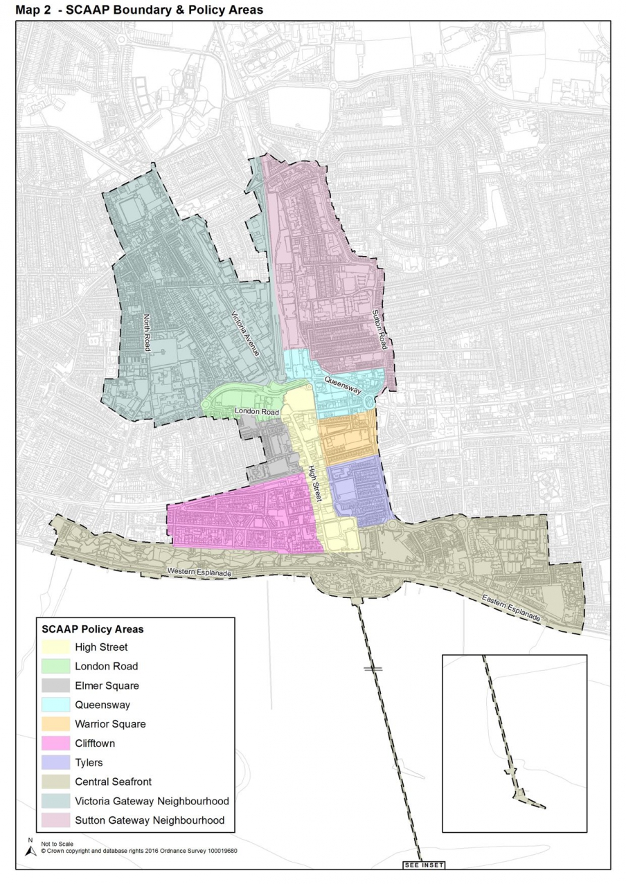
31 Spatially, this concept embraces the vision of Southend as a prosperous regional centre defined by sustainable growth of its urban functions and the identification of Southend as a location of choice for businesses, residents and visitors. This will be achieved through the creation of Policy Areas and Opportunity Sites (see Map 2: SCAAP Boundary and Policy Areas), which will guide new development.
32 The SCAAP establishes Policy Areas which, to varying extents, take on a new mixed-use sustainable character. Development within these Policy Areas will be appropriate to their context, either seeking to strengthen the existing competitive advantage of current uses, encourage a greater mix of uses or defining new roles, contributing to the regeneration of the identified opportunity sites as well as Southend Central Area as a whole.
33 The introduction of new residential uses as part of a broader mix is a key element in achieving a vibrant, thriving Town Centre.
34 The Policy Areas have been identified as follows:
- High Street
- London Road
- Elmer Square
- Queensway
- Warrior Square
- Clifftown
- Tylers
- Central Seafront
- Victoria Gateway Neighbourhood
- Sutton Gateway Neighbourhood
35 Within the Policy Areas there are also a number of 'Opportunity Sites'. The approach for managing these sites, and wider policy areas, is set out in Part C: Policy Areas and Site Allocations.
4. Criteria Based Policies
4.1 Introduction
36 This section sets out the policy context for key uses and development within Southend Central Area. It includes a strategy and, where relevant, policies[4] for the delivery and management of:
- Retail
- Employment
- Housing
- Tourism, Culture, Leisure, and Recreational facilities
- The Historic Environment
- Open and Green Spaces
- Key Views
- Landmarks and Landmark Buildings
- Flood Risk Management and Sustainable Drainage
- Transport, Access and Public Realm
- Infrastructure Provision (including education, health and social and community facilities)
4.2 Retail
Southend Town Centre's Primary Shopping Area
(2) 37 The Primary Shopping Area of Southend's town centre (see Map 3 andPolicies Map) is focused around a long, well established linear High Street, and anchored by The Victoria shopping centre to the north and The Royals shopping centre to the south.
38 New retail development should complement and strengthen the offer of the town centre, in accordance with Core Strategy Policy CP2: Town Centre and Retail Developmentand the provisions of the National Planning Policy Framework (NPPF), reinforcing pedestrian circuits around the two main shopping centres.
39 Opportunities for additional retail floorspace will be expected to arise from some incremental increases in existing floorspace through extending shop units or creating larger trading areas through internal unit reconfiguration[5]. Additionally, consideration and use of vacant floorspace, particularly in The Victoria shopping centre should be made.
40 The following Policy Areas and Opportunity Sites are located/partly located within the Town Centre Primary Shopping Area and have the potential to deliver additional retail floorspace where opportunities arise:
- P1 High Street;
- P2 London Road;
- P4 Queensway and Opportunity Site PA4.1 along Southchurch Road;
- P6 Clifftown (for small scale niche retail);
- P7 Tylers, including Opportunity Site PA7.1.
41 Public realm enhancements throughout the town centre, particularly within areas that have existing poor quality environments, would be expected to increase footfall and assist with letting vacant units. A schedule of access and public realm improvements is set out within the development principles of each Policy Area.
42 Outside the Town Centre Primary Shopping Area, the Council may permit additional small-scale convenience retail provision to meet the needs of residents. Details are contained in each of the relevant Policy Areas.
Town Centre Primary and Secondary Shopping Frontages
43 The retail sector is crucial to the health of the local economy in terms of its attraction to visitors, business and investment. The changing nature of the 'High Street', facing competition from internet shopping, out-of-town retail parks and neighbouring centres, has impacted the level of trading in the Town Centre, and consequently there is a need to enhance and broaden its offer and function to possibly further include other complimentary uses.
44 However, an over-concentration of non-retail uses within the primary frontage can detract from its shopping function and may prejudice its vitality and viability, create extensive lengths of 'dead' frontage and a lack of proper or conventional shop window displays. Maintaining a high concentration of retail uses ensures the attractiveness of the centre as an accessible, diverse shopping area; which is paramount to the vitality and viability of the local economy.
45 Town Centre Primary and Secondary Shopping Frontages, as defined on the Policies Map (and outlined on Map 3 below), perform a vital role by managing the shopping function of the town centre to ensure its long term vitality and viability is not significantly harmed as a sub-regional destination.
46 To ensure that a healthy balance of uses is maintained, the Council will actively manage the concentration of different Use Classes (under the Use Class Order) within the Primary Shopping Frontages, as depicted on the Policies Map. By designating and protecting key frontages it is possible to manage the proportion of retail and non-retail uses which will help to ensure that the town centre remains an attractive place to shop.
47 The Council recognises that shopping should be just one part of a rich mix activities within the Town Centre. Therefore, Policy DS1 seeks to manage the designated primary frontages so that the proportion of retail use does not decrease below 60%. This approach not only seeks to secure the primacy of retail within these frontages by setting a percentage target, but also allows for an increase in supporting non-retail town centre uses when compared to the existing policy approach (80%)[6]. It also recognises that these primary frontages are crucially supported by adjacent secondary frontages, which do not include a retail percentage target, and therefore allows for further diversification of the town centre and its offer to further sustain its role of a retail, leisure and lifestyle destination.
(1) 48 It is also important to understand that Southend's town centre is perpendicular and well connected to the central seafront area. The central seafront area represents an important visitor destination in its own right, comprising a range of leisure uses, which together with the town centre supports a wider multifunctional Central Area within Southend that offers a unique and diverse visitor/ shopper experience.
49 The entire High Street length measures approximately 0.5 miles, a considerable distance for a high street. It is considered that the primary shopping frontage of the town centre comprises three inter-related distinct zones, the High Street, The Victoria Shopping Centre and The Royals Shopping Centre. Each of these zones should maintain a core retail function, but also be able to provide for a range of supporting town centre uses, particularly Class A3 restaurants and café uses, in order to enhance the experience for visitors and help towards achieving a low vacancy rate within the area.
(1) 50 The SCAAP substitutes all primary frontage not located on the main high street or the ground floor levels of the two respective shopping centres (The Victoria and The Royals) with secondary frontage. This reduces the length of primary frontage in the town centre by approximately 40% as compared to that designated by the Southend Borough Local Plan (1994).
51 Secondary shopping frontages located within the town centre, as defined on the policies map, are often located adjacent to a 'high street', and allow for a greater number and diversity of uses.
(1) 52 Where an empty unit has little prospect of being occupied within a primary or secondary shopping frontage in the short term, the Council will encourage the landowner/landlord to display local art within the windows to create visual interest from the public realm.
Permitted Development Rights and Temporary Uses
53 Under permitted development rights[7] buildings in specific Use Classes, including A1 Retail, are able to change to a number of alternative Use Classes, either for a temporary period or indefinitely. However, there will remain instances where prior approval applies as part of the permitted development or the change of use of a building does not constitute permitted development and would require the granting of planning permission.
54 Where permitted development is sought and prior approval is applicable Policy DS1 will apply as follows:
- Within Primary Shopping Frontages the following will
apply:
- The 60% retail threshold will equate to an "adequate provision of services"
- The marketing criteria in Appendix 8 will apply in determining whether "there is a reasonable prospect of the building being used to provide such services".
- A "key shopping area" is the same as the Primary Shopping Frontages and Secondary Shopping Frontages as defined on the Policies Map.
55 In respect to Policy DS1.4(a) vacant units could include units occupied for temporary or 'flexible' uses, permitted through a temporary planning permission or under permitted development rights.
56 For the purposes of calculating the proportion of retail in any given frontage (in respect to policy DS1 point 4a, any building operating under a permitted 'flexible use' at the time of assessment will be considered on the basis of the use class it had prior to the temporary use change. For example, a retail shop (A1) which has temporarily changed its use to a café or restaurant (A3) under the permitted development rights would still be considered as an A1 unit for the purposes of determining the overall percentage of retailing (A1) or whether there are more than two consecutive non-A1 uses.
Development Management Policy
57 Development Management Policy DM13 (Shopping Frontage Management outside the Town Centre) identifies 3 discreet areas of Secondary Shopping Frontage within the central area, which act as local centres and are located outside the Town Centre Primary Shopping Area. The boundaries of these are defined on the Policies Map.
|
(5) Policy DS1: A Prosperous Retail Centre |
|
|
* The measurement will be applied separately to each distinct Town Centre Primary Shopping Frontage zone, these being the High Street (944m), Victoria Shopping Centre (367m) and Royals Shopping Centre (405m) ** exceptions to this will be considered if it can be demonstrated to the satisfaction of the Council that the A1 use is no longer viable through an effective 2 year marketing exercise where the vacant property has been offered for sale or letting on the open market at a realistic price and no reasonable offers have been refused. Appendix 8 sets out further information to be provided in relation to marketing of vacant floorspace. |
|
|
|
|
|
Core Strategy DPD Strategic Objectives: 3, 5, 6, 8 |
Policies: KP2, CP2 |
|
Southend Central AAP Objectives: 1, 2, 8 |
Policies: PA1, PA2, PA4, PA6, PA7 |
*This Policy Linkage Box provides a summary of key inter-related local policies. Other planning policy and guidance not listed here may also be applicable and, therefore, a full assessment should be undertaken.

4.3 Employment
(1) 58 Southend, unlike many other traditional seaside locations, was quick to supplement its major industry as a tourist destination with other sectors following the increased accessibility of overseas travel and a decline in the tourism industry in the 1960s and 1970s. The employment base of Southend as a whole has become increasingly diverse. While tourism remains a central pillar of Southend's employment base, the creative and cultural sectors, aviation and medical technologies are all growing and offer further potential for growth in the future. The Town Centre is a sustainable location for significant employment growth. This growth is concentrated in service sectors that require flexible and good quality offices, such as those for finance and business services as well as knowledge based creative industries.
59 It is recognised that delivery of the Core Strategy employment target (7,250 additional jobs to be delivered in the Town Centre and Central Area between 2001 – 2021[8]) is challenging, particularly following the impacts of the global economic downturn. In fact, monitoring of employment data across the Borough suggests that job numbers have declined over the plan period. However, more recently, since 2010, job numbers have begun to increase and efforts to boost job creation are underway. Clearly, the Borough-wide employment targets as set out in the Core Strategy will be reviewed as part of preparing a new Southend Local Plan. Nevertheless, the SCAAP will seek to maximise employment opportunities and the SCAAP is seen as an important catalyst in helping to deliver a sustainable balance of new jobs alongside housing within the Central Area.
60 The South East Local Enterprise Partnership (SE LEP), a business-led partnership, has enabled the Council to secure a range of measures to support regeneration and growth. One such initiative, The Southend City Deal provides support for small and medium-sized businesses, seeks to create new jobs, and attracts inward investment. An incubator system of one-on-one support ('The Hive'), based in the former Central Library on Victoria Avenue (in the Victoria Gateway NeighbourhoodPolicy Area), will help to improve business performance, safeguard jobs, and form part of the regeneration of Victoria Avenue.
Offices
61 The market for office space within the Central Area is oversupplied with outdated office stock, particularly within Victoria Avenue Office Area (Opportunity Site PA8.1). Much of this stock is too large, underused/vacant, and unlikely to meet the changing requirements of small to medium sized occupiers - the focus of demand for office space in Southend. Providing a range of flexible, good quality, offices as part of mixed use developments will help to create viable proposals and a better balance of space than currently on offer.
62 Flexible, good quality office development is principally promoted in the following policy areas High Street, London Road, Warrior Square, Clifftown, Tylers, and Victoria Gateway Neighbourhood Policy Area. The policies for these areas, and opportunity sites are set out within Part C: Policy Areas and Site Allocations of this plan.
Southend as a Knowledge-Based Employment Centre
63 With the assistance of the university campus, Southend has significant potential to become a knowledge-based employment centre, utilising links with the A127 strategic corridor, the growth of London Southend Airport and the associated business parks, provision for which is made within the London Southend Airport and Environs Joint Area Action Plan (JAAP).
64 Southend has a high level of business start-ups. To date, business survival and therefore growth has struggled. Providing the support and infrastructure required to sustain and grow local businesses will be a crucial component in addressing this, and such activity will be supported by the Southend City Deal incubator hub (the Hive) at Victoria Avenue.
Southend's Cultural and Creative Industries
65 The Southend Cultural Strategy 2012-2020 sets out the vision for Southend: 'To be recognised as the cultural and leisure capital of the East of England'. The town has a significant concentration of creative and cultural businesses located across the Borough, particularly in the Town Centre.
66 The Local Economic Assessment (2013) outlines that whilst the creative and cultural industries have significant employment and wealth generating capacity, they also have the ability to create a step change in the economy, attracting new, ambitious people to Southend.
|
Core Strategy DPD Strategic Objectives: 1, 2, 3, 4, 5 |
Policies: KP1, CP1 |
|
Development Management DPD |
Policies: DM10, DM11 |
|
Southend Central AAP Objectives: 1, 9 |
Policies: PA2, PA5, PA6, PA8, PA9 |
*This Policy Linkage Box provides a summary of key inter-related local policies. Other planning policy and guidance not listed here may also be applicable and, therefore, a full assessment should be undertaken.
4.4 Housing
(1) 67 There are a number of existing residential areas in the Central Area. However, when compared to the rest of the Borough, the core town centre has relatively few residential properties.
(1) 68 Delivering new homes within Southend Central Area, including residential above ground floor commercial, will contribute to creating sustainable communities that will add critical mass to support the vitality and vibrancy of the town centre, throughout the day and evening economy.
69 New housing development within the Central Area will be encouraged to provide a mix of housing types and sizes, including affordable housing, in accordance with Core Strategy CP8 (Dwelling Provision) and Development Management Policies DM7 (Dwelling Mix, Size and Type), DM8 (Residential Standards), DM9 (Specialist Residential Accommodation); although care will need to be taken to ensure there is a balanced housing offer, taking into account the existing tenure mix of a particular area.
Scale of Residential Development
70 The SCAAP is considered to be an important catalyst and driver for inward investment and for the delivery of the remaining proportion of planned regeneration and growth in the Southend Central Area to meet, or exceed, Core Strategy targets up to 2021.
(1) 71 Further work has been jointly undertaken to establish an objectively assessed need, in terms of jobs and housing, for Southend and its surrounding housing market area. Following publication of this evidence, preparation of a Southend Local Plan will commence alongside delivery of the SCAAP. The Local Plan will set out new growth target replacing those of the adopted Core Strategy and will review unimplemented development sites within the SCAAP.
(2) 72 The Core Strategy requires at least 2,474[9] net additional new dwellings to be provided within Southend Central Area during the period from 2001 to 2021. According to the Southend Annual Monitoring Report (AMR), between 2001 and 2016, 1,087 dwellings have been built within the Southend Central Area. An additional 1,732 net dwellings have been identified through Opportunity Sites and 1,040 of these have planning permission as of 1 April 2016. A further 434 dwellings have been identified by outstanding planning permissions located outside of the opportunity sites and are predicted to be delivered by 2021, see table 1 below.
Committed = with planning permission or prior approval
(2) 73 Appendix 6 shows the amount of dwellings identified to be delivered by 2021 within the SCAAP area and relationship with the Core Strategy targets, further details are also included within each Policy Area, Part C: Policy Areas and Opportunity Sites.
Student Accommodation
74 The University of Essex and South Essex College have a strong presence within the Central Area, reinforced in recent years by the delivery of phase 1 of Elmer Square with The Forum opening in 2013. The Core Strategy makes provision for the regeneration of the town centre and Central Area led by the development of the university campus, and it is anticipated that the higher and further education sector will continue to expand, with increases in student numbers.
75 There will be a need to provide student accommodation, much of which could be within the Central Area. The provision of student accommodation can often be met through purpose built development, such as the existing University Square development within the town centre, or through the private rented sector. The Council will support the provision of well-designed student accommodation in Southend Central Area, as it provides a sustainable location for students, with easy access to the university and college buildings. It will also help to contribute to the aim of increasing the residential population and potential spend in the Central Area.
76 The University of Essex has an accreditation scheme that all approved private landlords must meet, and this provides a measure to ensure student accommodation is of high quality and meets the needs of students. Development Management Policy DM8: Residential Standards sets out the internal space standards that all non-self-contained accommodation, such as student accommodation, will be required to meet.
|
Core Strategy DPD Strategic Objectives: 6, 7, 14 |
Policies: KP1, KP2, KP3, CP8 |
|
Development Management DPD |
Policies: DM1, DM7, DM8, DM9 |
|
Southend Central AAP Objectives: 1, 2, 3, 8, 10 |
Policies: PA1, PA2, PA4, PA5, PA6, PA7, CS1, PA8, PA9 |
*This Policy Linkage Box provides a summary of key inter-related local policies. Other planning policy and guidance not listed here may also be applicable and, therefore, a full assessment should be undertaken.
4.5 Tourism, Culture, Leisure and Recreational Facilities
|
'To be recognised as the cultural and leisure capital of the East of England.' Southend-on-Sea Cultural Strategy 2012-2020 |
(1) 77 Southend Central Area will continue to be the primary focus for further enhancement of tourism, cultural, leisure and recreational attractions and facilities. This will build on the town's role as a major destination resort and contribute to a stronger, more vibrant centre.
78 There have been a number of recent developments within Southend Central Area that have helped to progress Southend's tourism and cultural offer, including investment in attractions in the central seafront area, such as at Adventure Island and the new lagoon at three shells beach, the Royal Pavilion cultural centre at the end of the Pier, the relocation of the Beecroft Gallery to the former central library building on Victoria Avenue, the relocation of the Focal Point Gallery to The Forum at Elmer Square, the regeneration of the former Palace Hotel as the Park Inn, and the new Premier Inn development on Eastern Esplanade, which has increased the quality as well as capacity of hotel offer.
79 Despite recent successes, the range of commercial leisure and recreational uses on offer in thetown centre is moderate, and enhancing this could serve to diversify the centres offer overall as well as draw in additional visitors and investment. The strategy for the Central Seafront Policy Areawithin this Plan (see Part C) seeks to create a seamless connection between the Seafront and the Town Centre. Clearly the Seafront offers a considerable commercial leisure offer, and providing better connectivity between these areas may well be a positive way of maximising the attraction of the Southend Central Area.
(1) 80 Tourism is an important economic driver for the Town Centre. However, the tourism industry still tends to operate on low levels of overnight stays, and the relatively short supply of high quality hotels, bar those mentioned above, and current restaurant offer in the Central Area may not attract those visitors with more spending power. The refresh of the Southend Local Economic Assessment (2013) concludes that potential remains to improve and diversify the tourism offer to increase overnight and longer stays and add value, whilst at the same time, harness the spending power of visitors and out commuting residents alike.
(2) 81 The tourism and hotel sector is expected to grow in Southend over the next 20 years. The Development Management DPD (Policy DM12: Visitor Accommodation) seeks to manage this growth by focusing new visitor accommodation to the Central Area, London Southend Airport and at locations with good access and a clear and strong relationship with the seafront. The Central Seafront Policy Area, in particular, offers a good location for the development of visitor accommodation, given close proximity to both the Town Centre and Seafront.
82 Enhanced evening attractions, including provision of restaurants, have the potential to address concerns about the vitality of the evening and night-time economy through improved management and maintenance of the Town Centre, and by providing more pedestrian activity after shopping hours to help tackle the perception of safety after dark.
83 This could be complemented by increased public art provision and streetscape improvements to enrich the streetscape and enhance the quality of the public realm – purveying the Central Area's cultural qualities and promoting legibility and way finding. The Council will seek to establish an increase in public art provision, where possible with local artists, within the Central Area, in line with its Public Art Strategy, to create a 'Central Area Art Trail'.
|
Core Strategy DPD Strategic Objectives: 1, 2 13, 14, 15, 18 |
Policies: KP1, KP2, KP3, CP1, CP4, CP6, CP7 |
|
Development Management DPD |
Policies: DM1, DM6, DM10, DM12 |
|
Southend Central AAP Objectives: 1, 3, 5, 6, 7, 8, 10 |
Policies: PA1, PA2, PA3, PA4, PA5, PA6, PA7, CS1, CS4, PA8, PA9 |
*This Policy Linkage Box provides a summary of key inter-related local policies. Other planning policy and guidance not listed here may also be applicable and, therefore, a full assessment should be undertaken.
4.6 The Historic Environment
(1) 84 This Plan seeks to celebrate heritage and to conserve and enhance Southend Central Area's heritage assets in a manner appropriate to their significance, with the emphasis on high quality design in all development proposals. Heritage assets are an important component of the tourist economy and play a crucial role in the identity-making. Development Management Document Policy DM5: Southend-on-Sea's Historic Environment sets out the local approach to the management of the historic environment within the Borough.
85 Development proposals within the Central Area, including enhancements to the public realm, will be responsive to the setting of heritage assets and should seek to improve the quality of their environmental context. Heritage assets will be promoted and enhanced as part of the future development of the town.
86 Policy criteria regarding the historic environment are provided within the relevant Policy Areas and Opportunity Sites set out in Part C of this Plan, details of which are provided within the Policy Linkage box below. It should be noted that listed buildings, buildings in Conservation Areas and scheduled monuments are exempted from the need to comply with energy efficiency requirements of the Part L Building Regulations where compliance would unacceptably alter their character and appearance.
Conservation Areas
(1) 87 There are a number of Conservation Areas within the Central Area, as depicted on the Policies Map. These include: Prittlewell, Eastern Esplanade, The Kursaal, Clifftown, and Warrior Square. Each has its own unique character which must be conserved and enhanced.
Listed and Locally Listed Buildings
(1) 88 Southend Central Area contains a large number of listed and locally listed buildings, which help define the town's unique heritage. A list can be found on the Council's website www.southend.gov.uk
Frontages of Townscape Merit
(1) 89 Frontages of Townscape Merit are non-designated heritage assets and apply specifically to historic facades, many of which are shopping parades. This designation, as depicted on the Policies Map, will be a material consideration for planning applications affecting these frontages.
Archaeology
90 Within this relatively small area there have been archaeological discoveries dating from the earliest evidence of humans in the area, to the medieval and later periods. The highest concentration of finds is in the Prittlewell area. Some of this area has been excavated for brickearth and other minerals but this remains the historic heart of the town and the potential for new finds is still significant.
91 Two Scheduled Ancient Monuments are located close to the Southend Central Area boundary. Prittlewell Priory just north of the area and Southchurch Hall to the south east. Immediately to the east of Prittlewell Priory are Roman and early Saxon cemeteries, which included the chambered tomb of the 'Prince of Prittlewell', a discovery of international significance.
Areas of Archaeological Potential in Southend Central Area
92 Although most of Southend Central Area has been previously developed there are still areas of archaeological interest where there is potential for new finds. In particular, these sites include:
1. Seaways Car Park area (Opportunity Site CS1.2)
2. Roots Hall area
3. Nazareth House
4. Southend Cliffs (which includes Opportunity Site CS1.4)
93 Any additional areas that are subsequently considered to exhibit significant archaeological potential, should be assessed in line with national guidance and Policy DM5 of the Development Management Document.
|
Core Strategy DPD Strategic Objective:14 |
Policies: KP2, CP4 |
|
Development Management DPD |
Policies: DM1, DM4, DM5, DM6 |
|
Southend Central AAP Objective: 7 |
Policies: Transport and Access Strategy, DS3, DS5, PA1, PA5, PA6, CS1, PA8 |
*This Policy Linkage Box provides a summary of key inter-related local policies. Other planning policy and guidance not listed here may also be applicable and, therefore, a full assessment should be undertaken.
4.7 Open and Green Spaces
(1) 94 Southend Central Area includes the Benfleet and Southend Marshes European Marine Site, encompassing both the SPA and Ramsar, which comprises the intertidal part of the Thames Estuary and also constitutes a Site of Special Scientific Interest (SSSI).
95 The Appropriate Assessment (AA) of the Core Strategy highlights that Core Strategy Policy KP1, which promotes development in the seafront area, is likely to result in increased recreational and development pressures on designated international and European sites. It is therefore imperative that Southend Central Area provides and enhances functional open and green space, such as pocket parks and play areas, linked to other attractive destinations in and around the Borough, in order to assist with relieving pressure on the Borough's designated sites. This builds on, and is embedded within, the South Essex Green Grid Strategy and Thames Gateway Parklands Initiative which seek to help promote South Essex as a green place, improving the local environment and access to it, linking all green spaces where possible.
96 The existing green spaces within Southend Central Area are depicted on the Policies Map. The Central Seafront Policy Area provides access to an abundance of green and open space. However, the Town Centre, in comparison, has relatively few areas of such space. This deficit will be addressed within the relevant Policy Areas and Opportunity Sites.
(2) 97 Particular attention will be paid to the improvement of existing public spaces and to the creation of new public and civic spaces. Existing and new green and open spaces will be linked together in a legible network. New green and open spaces should be linked through the green grid, and should seek to contribute to local biodiversity and, together with other urban greening measures such as green walls, improved landscaping, and tree planting, help mitigate the effects of climate change.
98 In order to ensure these open and green spaces are accessible they should be connected by an attractive network of accessible streets, and the quality of the public realm will be a key component in defining Southend Central Area as an urban environment where people want to live, work, visit and move around. The Transport, Access and Public Realm Strategy of this plan, the Council's Design and Townscape Guide SPD and Streetscape Manual SPD should be referenced for all street works within the Central Area.
|
Core Strategy DPD Strategic Objectives: 14, 18 |
Policies: KP2, KP3, CP4, CP7 |
|
Southend Central AAP Objectives: 3, 6 |
Policies: DS5, PA1, PA3, PA4, PA5, PA6, CS1, PA8, PA9 |
*This Policy Linkage Box provides a summary of key inter-related local policies. Other planning policy and guidance not listed here may also be applicable and, therefore, a full assessment should be undertaken.
4.8 Key Views
99 There are a number of 'Key Views' from within, and of, Southend Central Area that further help to define its character, including links with the Thames Estuary. The Council will seek to ensure that Key Views, as identified below, are not adversely impacted by development:
- The Seafront – views to and from the seafront, with particular recognition given to views from: Westcliff Parade; Clifftown Parade; Clifton Terrace; Royal Terrace; Pier Hill; Pier Head; Queensway; Western Esplanade; Marine Parade; and Eastern Esplanade.
- Southend Pier – with particular recognition given to views from: the High Street in order to enhance the link between the town centre and seafront; Eastern Esplanade; Western Esplanade; Marine Parade; Royal Terrace; and Clifftown Parade.
- The Kursaal – with particular recognition given to views from: Marine Parade; Eastern Esplanade; Lucy Road; Queensway and Southchurch Avenue.
- Royal Terrace and Clifftown Parade– with particular recognition given to views from Western Esplanade.
- All Saints Church(outside of the SCAAP boundary) – with particular recognition given to enhancing the setting of this heritage asset, improving the quality of the public realm at Queensway dual carriageway;
- Porters(outside of the SCAAP boundary) – with particular recognition given to enhancing the setting of this heritage asset, improving the quality of the public realm and highway at Queensway dual carriageway;
- St Mary's Church (outside of the SCAAP boundary) – with particular recognition given to improving the setting of this heritage asset, improving the quality of the public realm and highway junction at Victoria Avenue/East Street.
|
New development within Southend Central Area will be expected to demonstrate that it is compatible with and/or enhances Key Views of:
|
|
Core Strategy DPD Strategic Objective: 14 |
Policies: KP2, CP4 |
|
Development Management DPD |
Policies: DM1, DM4, DM5, DM6 |
|
Southend Central AAP Objectives: 2, 7 |
Policies: PA1, PA4, PA6, CS1, PA8 |
*This Policy Linkage Box provides a summary of key inter-related local policies. Other planning policy and guidance not listed here may also be applicable and, therefore, a full assessment should be undertaken.
4.9 Landmarks and Landmark Buildings
|
A Landmark Building is defined as one that has become, or may become, a point of reference because of its positive contribution to place making. This may include reference to its height, siting, distinctive design or use that sets it apart from surrounding buildings. Examples may include: churches, theatres and town halls. |
100 Landmarks or Landmark buildings provide orientation and aid way-finding. They are relatively limited in number and generally occupy strategic locations such as road junctions, terminations of vistas, and corners.
101 A building or feature will not be considered a landmark simply owing to its height or massing, indeed many of the existing landmarks within Southend Central Area are of a modest scale; essentially they must be of high quality, recognisable and distinctive. A landmark could also be represented by a significant piece of public art, a distinct architectural feature, or use of innovative and distinctive materials.
(2) 102 For the purposes of the SCAAP, the following have been identified as existing landmarks and landmark buildings (Table 2, and Appendix 3):
Table 2: Existing Landmarks and Landmark Buildings
|
Adventure Island, Western Esplanade (Central Seafront Policy Area) |
Royal Hotel and Royal Terrace (High Street and Clifftown Policy Areas) |
|
All Saints Church, Sutton Road (outside of the SCAAP boundary) |
Seafront / Estuary (Central Seafront Policy Area) |
|
Central Library (former), Victoria Avenue (Victoria Gateway Neighbourhood Policy Area) |
South Essex College, Luker Road (Elmer Square Policy Area) |
|
Central Museum, Victoria Avenue (Victoria Gateway Neighbourhood Policy Area) |
St John's Church, Herbert Grove (Central Seafront Policy Area) |
|
Civic Centre, Victoria Avenue (Victoria Gateway Neighbourhood Policy Area) |
St Mary's Church, Victoria Avenue (outside of the SCAAP boundary) |
|
Cliff Lift, Western Esplanade (Central Seafront Policy Area) |
Swan Hall, Victoria Avenue (Victoria Gateway Neighbourhood Policy Area) |
|
Cliffs Pavilion, Station Road (Central Seafront Policy Area) |
The Forum, Elmer Square (Elmer Square Policy Area) |
|
Clifftown Church/Studios, Nelson Street (Clifftown Policy Area) |
The Kursaal, Eastern Esplanade (Central Seafront Policy Area) |
|
Park Inn Palace Hotel, Pier Hill (Central Seafront Policy Area) |
The Pier (Central Seafront Policy Area) |
|
Pier Hill Observation Tower and Lift, Pier Hill (Central Seafront Policy Area) |
University of Essex, Elmer Approach (Elmer Square Policy Area) |
|
Porters, Southchurch Road (outside of the SCAAP boundary) |
University of Essex Student Accommodation, London Road (Elmer Square Policy Area) |
|
Prittlewell Chapel, North Road (Victoria Gateway Neighbourhood Policy Area) |
|
103 New development should not compete with existing landmarks in terms of bulk or height, and views of these buildings should not be compromised by new development.
104 The following (Table 3) have been identified as potential locations for new landmark buildings and features within Southend Central Area, as detailed in the relevant Policy Areas and Opportunity Sites. These are also depicted on the Policies Map.
Table 3: Potential Locations for New Landmarks
|
Opportunity Site (PA7.1): Tylers Avenue (Tylers Policy Area) |
|
Opportunity Site (PA8.1): Victoria Avenue (Victoria Gateway Neighbourhood Policy Area) |
|
Central House, Clifftown Road (Clifftown Policy Area) |
|
Central Seafront Policy Area, including in particular Opportunity Site (CS1.2): Seaways, Opportunity Site (CS1.3) Marine Plaza, and Opportunity Site (CS1.4): New Southend Museum. |
105 Where considered appropriate in principle, development proposals for new landmark buildings and landmark features within Southend Central Area should demonstrate a coherent design approach, based on an understanding of the character, form and function of the surrounding townscape. Opportunities to enhance the setting of landmark buildings with improvements to the public realm, provision of open space, will be encouraged in order to retain views, enhance way-finding and to reinforce a sense of place.
106 Table 4 set out below and the Policies Map depicts the location of existing and potential Landmarks and Landmark Buildings by Policy Area.
|
1. The Council, through its role in determining planning applications, masterplanning, and other initiatives, will seek to conserve landmarks and landmark buildings as identified in Table 2 and Appendix 3 from adverse impact by:
|
|
2. The Council will support and encourage the creation of new landmarks in the areas identified within Table 3, where development proposals must demonstrate that:
|
|
Core Strategy DPD Strategic Objective: 14 |
Policies: KP2, CP4 |
|
Development Management DPD |
Policies: DM1, DM4, DM5, DM6 |
|
Southend Central AAP Objectives: 2, 3, 7 |
Policies: DS5, DS2, PA1, PA3, PA4, PA6, CS1, PA8 |
*This Policy Linkage Box provides a summary of key inter-related local policies. Other planning policy and guidance not listed here may also be applicable and, therefore, a full assessment should be undertaken.
Table 4: Existing and Potential Landmarks and Landmark Buildings by Policy Area
|
|
Existing Landmarks within |
Existing Landmarks near |
Potential Landmarks Within |
Potential Landmarks near |
|
PA1 High Street |
|
|
N/A |
|
|
PA2 London Road |
N/A |
|
N/A |
|
|
Policy PA3 Elmer Square |
|
N/A |
N/A |
N/A |
|
PA4 Queensway |
N/A |
|
N/A |
N/A |
|
PA5 Warrior Square |
N/A |
|
N/A |
|
|
PA6 Clifftown |
- Clifftown Church/ Studios |
|
|
|
|
PA7 Tylers |
N/A |
N/A |
|
|
|
CS1 Central Seafront |
|
|
|
|
|
PA8 Victoria Gateway |
|
|
|
|
|
PA9 Sutton Gateway |
N/A |
|
N/A |
N/A |
4.10 Flood Risk Management and Sustainable Drainage
107 Southend-on-Sea Borough Council, with the Environment Agency and Anglian Water Services Ltd. (Anglian Water) has formed a Local Flood Risk Management Partnership. The aim of this partnership is to work together to manage local sources of flooding.
108 The Core Strategy establishes a need to focus development within Southend Central Area, including the central seafront. The Southend Surface Water Management Plan (SWMP) and Strategic Flood Risk Assessment (SFRA) indicate that areas within the SCAAP are at risk from tidal and surface water flooding. A Level 1 SFRA was completed for Southend in September 2010 and a Level 2 SFRA in November 2010.
109 The Council has prepared a Local Flood Risk Management Strategy (LFRMS). The LFRMS outlines the priorities for local flood risk management across the Borough and provides a delivery plan to manage the risk over the next six years. The LFRMS complements and supports the National Flood and Coastal Erosion Risk Management Strategy published by the Environment Agency which outlines a National framework for flood and coastal risk. The SWMP, SFRA and LFRMS are available on the Councils website.
110 The extent of tidal flooding is limited to the Central Seafront Policy Area, Environment Agency Flood Zones 3a (higher risk) and Flood Zone 2 (lower risk). The SFRA indicates that sea levels are projected to rise so that more areas within the Central Seafront Policy Area will become increasingly affected by flooding over time.
(1) 111 To address this, the Essex and South Suffolk Shoreline Management Plan (2010) establishes an approach to hold the existing line of flood defence within the Central Area, which includes taking account of the effects of climate change. The Council will promote and help to deliver this strategic flood defence for the Central Area. It will do this by seeking Community Infrastructure Levy contributions from developers as well as seeking other sources of private sector and Government funding.
112 Given the long term timescales for implementing a strategic flood defence, the planning of individual new development sites also need to take into account the flood risk hierarchy as follows:
- Assess - a site specific flood risk assessment (FRA) may be required.
- Avoid (higher) flood risk areas – the Core Strategy establishes the need for new development within the SCAAP area. The sequential test will be applied within two separate areas: the Central Seafront Policy Area; and the remainder of the SCAAP area. The sequential test will also apply within individual Opportunity Sites.
- Substitute - more vulnerable uses should be located within parts of the development site at less risk of flooding. This will be balanced where necessary alongside other planning, design and deliverability objectives.
- Control and Mitigate – this will be a proportionate response taking account of the delivery of a strategic flood defence in the longer term, and the residual risk (that the defence is breached or overtopped). This will ensure that individual developments achieve an appropriate degree of safety over their lifetime.
113 The Policies Map does not does not depict the areas at risk of flooding. This is contained in the Strategic Flood Risk Assessment and any future advice and/or new information that will be provided by the Environment Agency. This approach is necessary to enable the flood risk data to be updated when required. Users should contact both Southend Borough Council and the Environment Agency to confirm the most up to date information.
Site-specific Flood Risk Assessment
114 A site-specific Flood Risk Assessment (FRA) will enable a developer to identify measures (if any) that are necessary to make a development safer and ensure it will not increase the risk elsewhere, to satisfy the Exception Test[10].
115 In accordance with national planning policy a FRA will be required for development proposals:
- 1 hectare or greater in Flood Zone 1;
- for new development (including minor development or change of use) in Flood Zones 2/3, or in areas within Flood Zone 1 which have critical drainage problems; and
- where proposed development or change of use to a more vulnerable use class may be subject to other sources of flooding.
(1) 116 It is the responsibility of a developer to undertake the site-specific FRA, and they are strongly advised to agree the content with the Environment Agency prior to submission of it with the application. The FRA should be commensurate with the degree of flood risk posed to and by the proposed development, and take account of national planning practice guidance. Information from the SFRA should be used when developing the FRA.
Sustainable Drainage
117 Sustainable urban drainage systems (SuDs) are designed to reduce the potential impact of new and existing developments with respect to surface water drainage discharges. SuDS try to replicate natural systems and use cost effective solutions with low environmental impact to drain away dirty and surface water run-off through collection, storage, and cleaning.
(1) 118 SuDS should be designed in accordance with the National Standards for Sustainable Drainage Systems (December 2011) guidance in the SuDS Manual (2007) published by Construction Industry Research and Information Association (CIRIA).
119 The 'core town centre' and central seafront policy area is characterised by a geology that exhibits low infiltration potential, although there are also surrounding areas where the geology offers greater permeability and potential for SuDs. The SCAAP area more widely is susceptible to localised surface water flooding, as indicated in the SFRA and Environment Agency online mapping. As such, all new development shall be drained via SuDS. It should be noted that SuDS must receive planning approval before construction is commenced and:
- For extensions and other single property developments the owner or developer will remain responsible for maintaining the system in good working order;
- For developments above single property scale, once the Council, as the Lead Local Flood Authority, is satisfied it has been constructed to an appropriate standard, the Council will adopt the SuDs for maintenance.
(1) 120 The design target will be to limit the discharge of the site run-off to green-field levels wherever possible. It may be found that this standard is not achievable, but any derogation will have to be approved by the organisation managing the receiving water system. For main rivers and ordinary watercourses this will be the Council, and for public surface water sewers Anglian Water.
(1) 121 Developers are encouraged to consider the layout of their SuDS proposals prior to any other site masterplanning is undertaken, and to discuss them with the Council, as SuDs have specific requirements for location and construction.
Other Considerations
122 In developing infrastructure schemes the Council will consider how these projects/improvements, such as highway, rail and public realm works, could be used to deliver flood risk/surface water management benefits. Similarly measures that would provide benefits to the environment, including the protection/enhancement of biodiversity, habitats, water quality and watercourses, will be considered.
|
(3) Policy DS4: Flood Risk Management and Sustainable Drainage |
|
1. Development proposals which are or will be within a flood risk zone:
01. Remain structurally sound in an extreme flood event; 02. Provide appropriate flood resistance / resilience measures to the extreme flood level; 03. Not generate an increase in flood risk elsewhere; 04. Provide a flood plan, which covers methods of warning and evacuation; 05. Provide an appropriate safe refuge above the extreme flood level if criterion 1bii is not met. * This is to ensure that floors must be set above the 1 in 200 annual probability event level plus climate change ** Freeboard is an allowance to take account of: (i) physical processes that affect the defence level, that have not been allowed for in the design water level and (ii) adverse uncertainty in the prediction of physical processes that affect the defence level Further technical information and definitions for this policy are included in Appendix 4 |
|
2. For all new development, the Council will require new impermeable areas to be drained via SuDS. This will ensure the risk of surface water flooding is not increased onsite or elsewhere. Under no circumstances will surface water be permitted to discharge into a separate foul sewer or sewerage system. Surface runoff that cannot be discharged into the ground, a surface water body or a surface water sewer or local highway drain, must be discharged to a public, combined sewer system. |
|
Core Strategy DPD Strategic Objective: 15 |
Policies: KP1, KP2, KP3, CP4 |
|
Development Management DPD |
Policies: DM6 |
|
Southend Central AAP Objective: 5 |
Policies: PA1, PA2, PA3, PA4, PA5, PA6, PA7, CS1, PA8, PA9 |
*This Policy Linkage Box provides a summary of key inter-related local policies. Other planning policy and guidance not listed here may also be applicable and, therefore, a full assessment should be undertaken.
4.11 Transport, Access and Public Realm
(4) 123 The level of regeneration and growth proposed for Southend Central Area will have an effect on the strategic transport network. The Transport, Access and Public Realm Strategy (Appendix 5), together with this Policy (DS5), seek to improve transport, access and connectivity, building on the approach set out within the Core Strategy and the Local Transport Plan (LTP).
(3) 124 This will be supported by a coordinated, sustainable public realm that addresses the principles of the Streetscape Manual SPD to create an attractive, inclusive environment for walking and cycling, improving the setting of, and links to, the Policy Areas and Opportunity Sites, and well-defined access points and gateways to the town centre and central seafront area, supported by accessible and well signed car parking servicing the entire SCAAP area. Map 4: SCAAP Car Parking, Access and Public Realm depicts the existing parking network, traffic information signs and information hubs, and as well as future public realm and access improvements to enhance connectivity within and through the Southend Central Area.
(1) 125 In respect of the public realm, there are instances in the Central Area where backs of buildings face onto the public areas, but have blank facades and are visually inactive thus creating a negative environment, particularly for pedestrians. Within the Central Area therefore, the Council will seek to encourage visually active frontages, particularly in specific locations identified on the Policies Map, in order to promote an enhanced urban environment.
126 The SCAAP has been used as a key evidence document to support the Council's priorities in the South East Local Economic Partnership's (SELEP) Strategic Economic Plan and Growth Deal, identifying funding priorities within Southend and the wider Thames Gateway South Essex (TGSE) sub-region.
127 There have already been positive outcomes from this, including funding for road and public realm improvements[11] within Southend Central Area to support the delivery of housing and economic growth, and as the SCAAP progresses it will be utilised to identify further opportunities for funding and partnership working. Specific schemes and projects are identified in the Implementation Section of this Plan.
(5) 128 With a low rate of car ownership in Southend Central Area there is a need and opportunities along access routes to allow other measures to be implemented that facilitate the use of sustainable transport modes, such as cycle lanes and bus priority measures, which will be implemented through the Local Transport Plan and associated strategies, together with linked improvements to the quality of the public realm.
(1) 129 Improving signage will aid way-finding, promote ease of movement through Southend Central Areaand should encourage more linked trips, highlighting linkages between the town centre and central seafront area, as well as between Southend Central Railway Station, Southend Victoria Railway Station and bus interchange, and the travel centre. Map 5: SCAAP Public Transport shows the public transport network within Southend Central Area.
Approach to Car Parking Management
(6) 130 Well informed and effective parking management techniques are likely to contribute towards an efficient transport network in and around the SCAAP area, ensuring that visitors are directed to convenient and accessible parking areas to access the many facilities and services that the town centre and central seafront area have to offer and helping to mitigate the negative impacts of congestion. To assist with development of this approach, Southend Borough Council commissioned a Car Parking Study (the 'Study') for Southend Central Area.
(2) 131 The Study reviews current and future car parking provision in Southend Central Area. It sets out the performance of the existing parking network, and the potential impact of development proposals on the network. It also assesses the economic importance of parking in Southend Central Area based on a recent survey of shoppers. As a result it provides a good indication of modes of travel and associated spend within Southend Central Area. It reveals that all visitors, including those who travelled by car, bus, train, cycle or walk, contribute to the local economy by spending in Southend Central Area. It also shows that generally car users spend more but visit less often than other mode users.
(4) 132 The Study found that the Southend Central Area parking network rarely exceeds 85% occupancy. On the busiest day of 2015 (a Saturday in August) the peak network demand in Southend Central Area was 87% occupancy from 15:00 to 16:00. At all other times, demand was below 85%. It did identify however that there is a clear imbalance in the Southend Central Area parking network at periods of peak demand, with car parking to the south of the central area experiencing overcapacity issues, while car parking to the north has available spare capacity. Overall, the Study shows that parking areas to the south of Southend Central Area were busiest, and exceeded 85% occupancy on one in every ten days between May 2015 and April 2016.
(1) 133 The Study also considered the impact of the proposed indicative development outlined in the SCAAP Opportunity Sites, as well as approved planning applications (as of 1 April 2016), on car parking. It revealed that the additional parking expected to be provided by development in Southend Central Area, supported by existing network provision, is likely to accommodate future demand for car parking generated in the plan period up to 2021. However, this is indicative only and further work will be needed, in the light of the Study, to ensure that parking supply is carefully balanced between the car parks and development sites north and south of the Central Area.
(5) 134 It is considered, therefore, that collectively the car parks located in Southend Central Area have the potential to serve both the Town Centre and Central Seafront, facilitating linked trips and increasing the potential for associated shared spend. Nevertheless it is also recognised that those car parks which are approximately 10 minutes' walk from the shoreline (south Central Area, i.e. those generally located south of the central railway line) are better positioned to provide more direct and convenient access to the Central Seafront area, which is the focus of the tourism and leisure resort.
(3) 135 The Study identifies around 2,550 publicly available car parking spaces to the south of the central area, approximately 10 minutes' walk from the shoreline, serving both the seafront and southern parts of the Southend Central Area. As a result of the peak capacity issues, as identified by the Study, and to support the vitality and viability of the central seafront area, it is expected that there will be no net loss of public car parking to the south of the Central Area. Given the constraints and limited land availability of the Central Area, opportunities to increase car parking to the south will be limited, however where viable and feasible, the Council will seek further provision in association with development. One example of this is the New Southend Museum (Opportunity Site CS1.4), which has planning permission for approximately 220 public car parking spaces.
(4) 136 Furthermore the SCAAP will also seek to ensure that the existing traffic management network is as efficient and effective as possible to manage these periods of peak usage of the road network and car parks. Car parking demand within the SCAAP network will be managed through a combination of the following measures:
- ensure there is no net loss in car parking to the south of the Central Area (located within 10 minutes' walk of the shoreline and generally located south of the central railway line), and to maintain overall capacity at a level that supports the vitality and viability of the SCAAP area, and enables the delivery of relevant Opportunity Sites;
- Seek to rebalance the discrepancies of parking supply and demand to the north and south of the Southend Central Area by acting on the outcomes of the Study;
- application of Policy DM15 of the Development Management Document, particularly in respect to the requirements for transport assessments, travel plans and parking standards;
- the use of Smart technology providing up to date customer information and enhancing Variable Messaging Signs (VMS), detailed below, to direct visitors to the car parks with appropriate capacity within the overall car parking network for the SCAAP area;
- significant improvements to the public realm and car parks, to create a safe and pleasant environment in which to park a vehicle, in combination with well-signed routes, enhanced pedestrian links with good legibility to and from different parts of the SCAAP area, particularly between the Town Centre and Central Seafront;
- flexible, responsible and differential competitive pricing arrangements for car parking within the overall SCAAP network to provide consumer choice and options, taking account of demand, as well as convenient ways to pay for and top up parking;
- keep car parking capacity and demand under review to ensure that this capacity remains at a level to assist economic growth and regeneration;
- deliver strategic junction and transport improvements to improve vehicle circulation and the promotion and implementation of sustainable transport measures.
Variable Messaging Signs and Managing Car Parking and the Network
137 An extension of the existing car park Variable Messaging Signs (VMS), or updated technology, is encouraged to direct drivers to the most convenient car park and avoid unnecessary circulating traffic.This may be particularly beneficial, together with the promotion of other sustainable travel modes, during seasonal visitor peaks where parking is at greater demand, such as the summer months and during December. Improving access to a number of the SCAAP car parks by managing the road network will provide enhanced access to and between SCAAP car parks and help reduce traffic circulating through the town centre and Central Seafront.
|
(144) Policy DS5 – Transport, Access and Public Realm |
|
* Parking capacity includes provision for cars, motorcycles, taxis, bicycle and Blue Badge holder provision |
|
|
Core Strategy DPD Strategic Objectives: 9, 10, 14 |
Policies: KP2, KP3, CP3, CP4 |
|
Development Management DPD |
Policies: DM15 |
|
Southend Central AAP Objectives: 3, 4 |
Policies: PA1, PA2, PA3, PA4, PA5, PA6, PA7, CS1, PA8, PA9 |
|
Local Transport Plan 3 (refresh) |
Policies:LTP Policy 2, LTP Policy 4, LTP Policy 21 |
*This Policy Linkage Box provides a summary of key inter-related local policies. Other planning policy and guidance not listed here may also be applicable and, therefore, a full assessment should be undertaken.


4.12 Infrastructure Provision
Central Area Infrastructure
138 Infrastructure will be required to support and, in some cases, enable the scale and location of growth set out in the Core Strategy. This includes the delivery of a significant number of new dwellings and jobs in the Central Area, which is expected to result in a notable increase in population. It is important that these residents have access to facilities and services and that these are in convenient locations to minimise the need to travel, creating sustainable communities.
139 The infrastructure types and projects vary, but include: education, health, transport, social and community facilities (such as museums, libraries and community buildings), flood risk management (see Policy DS4), utilities (such as water, gas and electricity), green infrastructure and open space/public realm (see section 4.7 and Policy DS5). All have been taken into account within the Southend Infrastructure Delivery Plan (IDP). Recent examples of new provision include a new Care Commissioning Group (CCG) facility at North Road, a new library at the Forum, the Royal Pavilion on the pier, the Beecroft art gallery and Prittlewell Chapel.
140 The IDP is produced to identify the range of infrastructure types and projects required to support growth. Importantly it identifies likely funding sources, delivery agents, timescales and priorities, and forms an important supporting document in relation to the Council's Community Infrastructure Levy (CIL) Charging Schedule. The document was produced through collaboration with key partners and infrastructure providers, and will be updated, where necessary, to reflect project delivery and change.
141 The mechanisms for requiring and encouraging infrastructure delivery include adopted planning policy, planning conditions, S106 agreements and planning contributions (via Southend Planning Obligation – A Guide to the Section 106 and Developer Contributions SPD); and the CIL. These mechanisms are broadly set out in the Core Strategy and CIL documents, and for this reason are not repeated.
(1) 142 Education: it is considered that the planned population growth in the Central Area will be accommodated via the expansion of existing schools, however, it is recognised that there may be a need for additional schools, and this will be kept under review. Consideration will be given to the provision of additional education facilities based on an assessment of expansion needs when and where appropriate development opportunities arise, particularly in the Sutton and Victoria Gateway Neighbourhoods.
143 Higher and further education is a key driver in providing economic and social benefits. The Council will support the expansion of higher education facilities in the Central Area through the continued development of South Essex College and The University of Essex's Southend campus to consolidate the role of Southend as an educational centre of excellence.
144 Health: the IDP identifies a need for new and enhanced GP floorspace provision in the Central Area, including extension, reconfiguration, refurbishment and re-equipping of surgeries.
(2) 145 Transport: opportunities identified in the IDP for local public transport measures (such as bus interchanges and stops, real time systems), local walking and cycling measures (such as cycle network upgrades and cycle parking), local traffic management and highway network measures (including minor junction modifications and local bus priority schemes), and local traffic control systems (upgrades to control systems and junctions).
146 Social and Community Facilities: all Policy Areas may provide opportunities for new and improved social and community facilities, particularly Victoria and Sutton Gateway Neighbourhoods. Regeneration in the Queensway and Warrior Square Policy Areas will also provide opportunity for further provision of social and community infrastructure, where feasible. The IDP identifies provision for a new museum on Western Esplanade (see Policy CS1 and Opportunity Site CS1.4).
147 Public Realm: future phases of the City Beach and Victoria Gateway public realm schemes are identified by the IDP as an infrastructure need within the Central Area (see Policy CS1). It also recognises the limited provision of children's play equipment in the Central Area, identifying opportunity for future provision in Warrior Square Gardens.
148 Utilities: Water companies are subject to a statutory duty to 'effectually drain' their area. This requires them to invest in infrastructure suitable to meet the demands of projected population growth. It has been demonstrated to the satisfaction of the Environment Agency and Natural England, that Southend Waste Water Treatment Works has adequate capacity to accommodate the Core Strategy growth targets to 2021 and beyond. However, developers will need to consider the effect of their development on the capacity of the local waste water network. Proposals will need to demonstrate that they will not overload this.
149 There is statutory provision for developers to fund additional sewerage infrastructure required to accommodate flows from a proposed development. Adequate sewerage infrastructure should be in place to serve the area before development progresses. Developers should seek pre-planning advice from Anglian Water at the earliest opportunity to ensure appropriate provision is made. Further details and useful guidance can be found on Anglian Water's website.
150 New development will require separate foul and surface water drainage/sewerage, as drainage of surface water to foul sewers is a major contributor to sewer flooding. Provision should be made for surface water to drain to SuDS systems (refer to Policy DS4).
151 In terms of water supply and sewerage, developers will be required to pay the infrastructure provider for any mains diversions resulting from development proposals.
|
Core Strategy DPD Strategic Objectives: 2, 4, 9, 13 |
Policies: KP1, KP2, KP3, CP3, CP4, CP6, CP7 |
|
Development Management DPD |
Policies: DM2, DM14 |
|
Southend Central AAP Objectives:1, 2, 3, 4 ,5, 6, 8, 10 |
Policies: DS5, PA1, PA2, PA3, PA4, PA5, PA6, PA7, CS1,PA8, PA9 |
|
COmmunity Infrastructure Levy |
Charging Schedule A guide to S106 and developer contributions Infrastructure delivery plan |
*This Policy Linkage Box provides a summary of key inter-related local policies. Other planning policy and guidance not listed here may also be applicable and, therefore, a full assessment should be undertaken.
[4] Where there is not a policy sited in this section of the Plan there is a 'Policy Linkages' box which highlights another Plan where relevant policies may be found.
[5] Southend Retail and Town Centre Study (2011)
[6] Southend-on-Sea Borough Local Plan (1994)
[7] Town and Country Planning (General Permitted Development) (England) Order 2016
[8] Core Strategy CP1: Town Centre (6,500), plus Seafront (750) = 7,250
[9] Core Strategy CP8: Town Centre (2,000), plus Seafront (550), minus SHLAA sites identified in the rest of the seafront outside the SCAAP area (76) = 2,474
[10] The Exception Test, as set out in paragraph 102 of the NPPF, is a method to demonstrate and help ensure that flood risk to people and property will be managed satisfactorily, while allowing necessary development to go ahead in situations where suitable sites at lower risk of flooding are not available.
[11] South East Growth Deal