Southend Central Area Action Plan & Proposals Map - Proposed Submission
8. Central Area Transport and Access Strategy
SCAAP Objectives 2, 3 and
- To improve the buildings a public realm, including accessible green space, within the Central Area, to manage traffic and improve cycling and walking facilities so that Southend becomes a place that is more pleasant to experience and move around in.;
- To always have regard to the significant biodiversity assets and environmental quality of the Central Area, help meet obligations on carbon emissions and adopt an approach to climate change through measures that mitigate against, or adapt to change, including managing flood risk and water efficiency;
- To promote design excellence in all things and to ensure that this quality standard is also expressed within the actions of our delivery partners.
8.1 Context
(1) 255. Ease of access to the Town Centre plays a vital role in maintaining the attraction for visitors, workers and residents, helps sustain businesses and supports the economy.
256. The issues linking accessibility by road, cycle, on foot and by public transport are interrelated and depend upon both the transport networks and support for the preferred mode.
257. This strategy proposes a number of policies and measures, within the context of the LTP3 and supporting documents, which seek to improve transport access and connectivity for all.
Features
258. The following main features affect the way people access and use the town and have influenced the future policy directions included in this document:
- In early stakeholder engagement, issues relating to congestion and pedestrian severance caused by the ring road were main weaknesses of the Town Centre.
- There are two busy distributor roads (A13 and A127) which are the main vehicular access roads to the Town Centre. These also provide a link from and to destinations en route to London/M25. Having only two main routes into Southend leads to some peak hour congestion and issues of reliability and resilience, particularly during the tourist season, busy weekends and bank holidays.
- Access to the Seafront from the Town Centre is via Queensway and Southchurch Road, which also severs the Town Centre from the residential areas to the east.
- Queensway frees a large part of the Town Centre from traffic and congestion, which could be further developed to reinforce its role.
- The Central Area is a transport interchange for public transport with improvements recently completed at Victoria Gateway and outside Southend Central Railway Station serving to demonstrate the type of improvements that bring the interchanges closer together and improve access for walking and cycling on shared priority routes. Signing of routes and ensuring safe, pleasant and attractive links will be essential.
- A number of car parks and on street parking spaces are accessed by travelling through the Town Centre, which means that the additional trips and road-space provision compromises public transport, pedestrians and cyclists and residential amenity for those streets immediately adjacent to the retail centre.
- The majority of Southend High Street is pedestrianised, without access to cyclists.
- Car parks are 70% full most of the time, with certain car parks having characteristic issues of frequency of use and under and over capacity due to their quality and location.
- There are two railway stations, Southend Victoria Station and Southend Central Station which travel to London Liverpool Street and London Fenchurch Street respectively. Both serve the High Street and yet are seen as separate entities in terms of service provider. Lack of information and signage in the High Street leads to a lack of awareness of the possibility of using the train for more local trips.
- The Travel Centre provides a comprehensive hub for the public to access buses. Southend collects data on the NI 178 bus punctuality national indicator, during September 2010, 73% of buses departing from the Travel Centre were on time (up to one minute before the scheduled time and 5 minutes after).
- The proximity of surrounding residential areas and flat topography mean that many residents can choose to walk or cycle to the Town Centre. 52% of residents in the Borough travel to work by car, only 6% use bus or coach and 8% travel by bicycle. 85% of people going to the Town Centre are from within the Borough. There is scope to encourage a modal shift.
8.2 Local Transport Plan
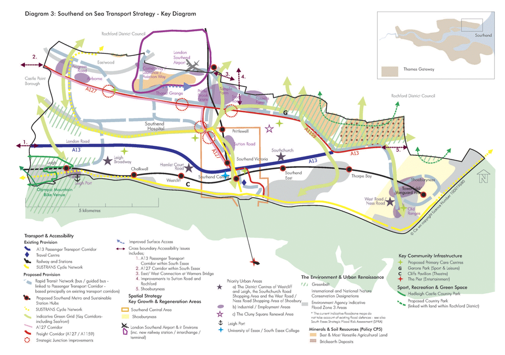
259. The Third Local Transport Plan (LTP3) covers a strategy period of 15 years from 2011. The overall goal of LTP3 is to “provide the Borough with a transport system that delivers sustainable economic growth, prosperity and helps to achieve the vision of a vibrant coastal town and a prosperous centre where people enjoy living, working and visiting” Map 6 – Southend-on-Sea Transport Strategy Key Diagram shows the over arching LTP3 transport strategy for the Borough and the role of the Central Area.
260. The policies within this transport section of the SCAAP are taken from LTP3 and expanded upon.
(3) 261. Objectives for Central Area Transport Access
- Balance the need to keep traffic flowing on the main road network to minimise congestion, especially delays to buses, with greater opportunities for pedestrians, cyclists and people with disabilities.
- Encourage the use of sustainable travel modes through smarter choices techniques and mobility management measures.
- Further improve public transport especially late night transport to help with the night time economy.
- Continue the programme of pedestrian improvements and encourage development that supports complimentary public realm and access improvements.
- Continue to develop and support the cycle route network, secure cycle parking and work with Cycle Southend in terms of promotion, marketing and the creation of cycle hubs.
- Improve the provision for taxis to support access, especially at night.
- Implement a quality signage and wayfinding scheme for pedestrian and ensure that vehicle electronic displays for car parks and travel information better relay details to road and public transport users
- Take forward the relocation proposals for the Town Centre car parks to ensure that appropriate balanced provision is made between the capacity of the identified strategic locations (arrival points) and demand from the various quarters.
- Ensure the relocated car parks are located close to ‘feeder’ highways (i.e. Queensway) with short direct access and egress routes to that highway
- Capitalise on the reduction in general traffic circulation in the Town Centre to establish strong connecting routes for pedestrians to and from the car parks to the retail and leisure circuits in the Town Centre, including better lighting and public realm features.
Map 6 – LTP3 Key Diagram
8.3 Town Centre and Central Area Highway Network
(1) 262. The A127 is a key component of the transport network providing the main strategic link from the Town Centre to the wider trunk road network across South Essex and the greater South East. It is heavily used by local traffic in and around the Borough for local trips. There is a high degree of dependency on the A127 for a number of important outcomes across a range of economic, environmental and planning outcomes. The development of an A127 Corridor Management Strategy is thus imperative to the future success of the Borough.
263. With that in mind and to complement the recent junction improvements carried out under the ‘Better Southend’ banner at Progress Road and Cuckoo Corner there will be improvements at the two other major junctions over that section of route, namely Kent Elms Corner and The Bell.
264. Upon arrival in the Town Centre, further development of the existing car park signage scheme and Variable Message Signs will direct vehicles on the network and to car parks using Queensway and to other key buildings/areas. Linked to a comprehensive traffic control system will allow this information to be displayed in a number of ways. Keeping traffic on the perimeter of the town will be a priority with selective and well signed entry points to car parks provided.
265. A new signage scheme is required to aid pedestrians, cyclists, and assist the high number of visitors to the town in finding key areas.
266. The provision of well maintained footways, pedestrianised areas, crossing points and cycle routes will encourage people to use sustainable modes to travel to the Town Centre.
267. Maintenance is key to ensuring the transport network remains fully serviceable at all times. A programme of maintenance that focuses on key routes such as, the A13 and A127 and areas with high pedestrian usage, such as the High Street, is being developed. The maintenance programme will also target footways, footpaths, cycle lanes and bus priority measures supporting significant mode shift to ensure that walking and cycling in particular is encouraged.
268. Road safety and accident investigation forms an important aspect of making the environment safer. An accident database is maintained and interventions will coordinated with the Action Plan.
(1) Policy TA1: Town Centre and Central Area Highway Network
Through the implementation of the Proposal Sites and policies in this AAP; the determination of planning applications; and other initiatives and partnership working; the Council will:1. seek to better manage demand on the road network leading to, from and within the Town Centre and balance this with the needs of other modes particularly where this would give greater reliability to road users and priority to pedestrians, cyclists, public transport users and people with disabilities;
2. seek to develop the priority route for SERT towards the Airport and adjacent development areas and corresponding junction improvements at A127/Fairfax Drive and East Street, in conjunction with the Development Brief for Victoria Avenue and potential relocation of the football club;
3. ensure that bus priority measures are focussed on the A13 passenger transport corridor (London Road and Southchurch Road) and the Queensway junctions at London Road, Southchurch Road and Seaways Car Park;
4. seek to develop appropriate treatments for both Sutton Road and North Road which go through the Neighbourhood Gateways;
5. reduce general vehicle circulation within the Town Centre by:
- relocating cars parks close to the ‘feeder’ highway network;
- actively direct vehicles around the outer cordons of the Town Centre instead of through the Town Centre to access car parks,
6. promote the pedestrianisation of a number of the High Street’s inter-linking access roads supporting access to car parks, greenspace and retail circuits;
7. promote pedestrian and cycle priority schemes to improve access to the Town Centre. Consider limited access to the pedestrianised areas by cyclists as part of a partnership approach with stakeholders and the Police;
8. ensure that servicing and delivery arrangements meet the reasonable needs of businesses, whilst ensuring that the environmental disbenefits are taken into account. Work with the freight industry and logistics to implement more efficient use of vehicles in terms of guidance, zoning and delivery timetables;
9. review signing and implement an integrated signing strategy for vehicles, buses, freight, pedestrians and cyclists, without providing too many signs to make street clutter. Make full use of technology to facilitate the shift to sustainable modes, such as intelligent transport systems (ITS), Variable Messaging Signs (VMS), and Real Time Passenger Information (RTPI). Ensure that signage is kept to an appropriate minimum and a review undertaken of existing signage to avoid proliferation, maintain all the transport networks in the Town Centre to an appropriate standard;
10. use appropriate road safety and accident site treatments.
8.3.1 ‘The Victoria’ – Traffic and Public Real Scheme
269. On approach to the Town Centre traffic either joins the Queensway “ring road” around the Town Centre or enters the Town Centre. The location of the car parks is one of the reasons for traffic entering the Town Centre. Severance caused by Queensway is a major issue and a number of crossing points provide access for pedestrians and cyclists. A major barrier exists at the junction of Queensway and Southchurch Road with the underpasses little used and pedestrians choosing to navigate into the Town Centre via the surface roundabout. The new Victoria Gateway Scheme supports a more integrated approach to public transport with a number of bus stops and routes clustered around Southend Victoria Railway Station.
270. The sert scheme seeks to develop the interchange at Victoria Gateway further to provide a high quality route linking the Seafront, Town Centre, Airport and Business Parks and the Hospital. This is being developed through the DfT Major Schemes process and awaiting formal programme entry.
271. Opportunities to redesign out the severance will be explored building on the new approach at Victoria Gateway. This has taken the first step towards realising the clear and distinct vision for those parts of Southend Town Centre collectively known as “The Victoria” as set out in the Southend Central Area Masterplan, March 2008.
Policy TA1a: ‘The Victoria’ Phases 2, 3 and 4 Traffic and Public Realm Scheme
Three distinct areas have been developed to take this forward:
1. Queensway (from Victoria Gateway Junction the London Road):- develop Queensway as an integrated part of the Gateway and redesign planting from the roundabouts thus opening visual and pedestrian and cycle links;
- consider an approach that decreases the width and impact of the highway corridor along Queensway to create a distinct built edge as part of the adjacent site redevelopment;
- new development along Queensway should bring active frontage to animate the street; and
- use landscape design and public art to open up and emphasise vistas.
- To create a more attractive, permeable and ?exible public space for events, relaxation and leisure use;
- To improve and enhance the links to Broadway, Southend Victoria Railway Station and The Victoria Shopping Centre;
- To explore opportunities for the introduction of quality and enduring public art and lighting and illumination; and
- To improve public safety and provide a comfortable, pleasant space to encourage activity and popular use.
- To improve pedestrian and cycle links to Queensway, Southend Victoria Railway Station and the University; South Essex College, Elmer Square and Central Station;
- To establish and extend pedestrian priority shared surfaces;
- To anticipate and support proposed new developments incorporating an active frontage enhancing opportunities for retailing and restaurant use.
8.3.2 ‘City Beach’ – Traffic and Public Real Scheme
272. Along the seafront route, The City Beach scheme has realigned the carriageway and removed the central reserve to create wider pavements and space for cafes, activities and created attractive features, fountains and lighting. The scheme incorporates the road and promenade from Southend Pier (Pier Hill junction along Marine Parade to the junction with Southchurch Avenue/Eastern Esplanade).
273. There is scope to continue the rationale for the City Beach scheme further to the east along Jubilee Beach between the main commercial seafront area to the former gas works site on the Eastern Esplanade.
(2) Policy TA1b: ‘City Beach’ Phase 2 – Traffic and Public Realm Scheme
1. The principles adopted within this extension would include:-- reconsider the layout of on-street parking to maximise the benefits of improving the public space (as demonstrated along City Beach) to further create opportunities for better pedestrian connections and opportunities for attractive public space and activities;
- consider introducing a surface treatment to the road to slow traf?c speeds and improve physical connections across the road and improve pedestrian connections to the beach, cafes, bars and the Town Centre;
- incorporate green, events and play spaces;
- support better cycling and public transport facilities;
- broaden the range of visitor attractions to extend the season, encourage longer stays and attract higher revenues;
- provide exciting lighting and public art to reintroduce the illuminations tradition;
- create a more diverse resort for Southend, drawing on potential growth in business and high income visitors attracted by new conference facilities, high class hotels and spa facilities set within a high quality public realm;
- enhance the ecological value of the site and respect the protected status of the foreshore;
8.4 Public Transport
274. In order to improve bus services and to encourage non-car trips to the Town Centre, the Council will work with bus operators to encourage behavioural change in travellers, through a wide programme of bus priority measures across the Borough and Town Centre. There is also a need to enhance services later in the evening to serve the night time economy.
275. This will involve working with bus operators to provide a more reliable and punctual bus service through the implementation of a Punctuality Improvement Partnership (PiP). In addition, through the development of the bus Advanced Vehicle Location (AVL) system, it is intended to implement a Borough wide seamless Smart Card ticketing for public transport that is integrated with other ticketing systems such as libraries and car parks.
276. In addition close partnership working with the train operators will continue to achieve high levels of reliability and performance on all services and that contra-flow interpeak services are maintained and promoted for journeys to Southend.
277. There are two railways lines and 9 surface railway stations throughout Southend and more linking to the broader sub-region, the promotion of the rail network as a ‘Southend Metro’ system, through integrated ticketing, marketing and integrated timetables will also be promoted with train operators to implement off peak use. This includes continued active participation in the development and marketing of Station Travel Plans.
278. Clearly there is a need to ensure that all forms of transport are equally accessible to all members of the community to encourage use by disabled, elderly, people with pushchairs etc. The Council will work to ensure all public transport is fully accessible by 2017.
279. The introduction of smart card and mobile phone technology will allow seamless ‘door-to-door’ travel on buses and trains and will be extended to include use on secure cycle parking, access to swimming pools, libraries, canteens etc.
(2) Policy TA2: Public Transport
The Council will work in partnership with public transport operators, businesses, residents and transport users to:
1. encourage a shift to travel by bus, or rail where practicable, for journeys between 5km (3miles) and 10km (6miles);2. make full use of technology to facilitate the shift to sustainable modes, such as intelligent transport systems (ITS), Variable Messaging Signings (VMS), and Real Time Passenger Information (RTPI);
3. promote improvements to the public transport infrastructure and services, including:- work with bus operators:
- improve bus services to the Town Centre including services later in the evening to serve the night time economy;
- provide a more reliable and punctual bus service through the implementation of a Punctuality Improvement Partnership (PiP);
- Improve the current bus Advanced Vehicle Location (AVL) system to a modern standard and reduce running costs,
- Work with train operators to:
- achieve high levels of reliability and performance on all services;
- maintain and promote contra-flow interpeak services for journeys to Southend;
- Promote off peak use of the rail network as a ‘Southend Metro’ system; and
- Continue active participation in the development and marketing of Station Travel Plans,
5. improve safety and security for use of public transport;
6. provide better quality public transport information and marketing to increase patronage;7. ensure all public transport is fully accessible to encourage use by disabled, elderly, pushchairs etc.
8.5 Walking and Cycling
(1) 280. Improving the pedestrian environment, routes and crossings will encourage more people to walk to the Town Centre. The provision of easy access to bus stops and walking routes (e.g. dropped kerbs at junctions) will be extended to promote walking for all abilities, as part of the “door to door “ travel chain. Presently the High Street is mostly pedestrianised and the Victoria Gateway scheme completed in 2011 has greatly improved pedestrian access across Queensway and Victoria Avenue into the High Street.
281. The future expansion of the High Street to the east to encompass Chichester Road will improve access to shops, businesses and the Travel Centre and significantly improve the public realm supporting walking and cycling. The backs of the existing shops require improvement and could provide access for customers both from the High Street and Chichester Road, thus improving streetscape and accessibility.
282. The Queensway roundabout causes severance to pedestrians and although there are underpasses, these are not perceived as safe during the hours of dark and some pedestrians prefer to take the shorter route across the roundabout which does not have any pedestrian facilities.
283. There is a perception that after dark the Town Centre can be an unsafe area, however, statistics show that levels of crime are average when compared nationally. Ensuring street lights are maintained, CCTV is obviously sited and public transport and taxis operate after dark can all help to improve the perception of safety.
284. At present there is poor access for pedestrians and cyclists from the southeast end of the Town Centre. York Road will be improved to provide an accessible walking and cycling route into the town.
285. Southend is a cycle town and has developed the Cycle Southend “brand” and website. This branding can be developed to further increase cycling through the provision of infrastructure and marketing. The provision of cycle routes and secure cycle parking will encourage cycling. Cycle parking will be provided for residents, visitors, students and employees. Increasing cycling will also help to reduce congestion, improve social inclusion and improve health.
286. The cycle hub would offer the public a full range of cycle related services, such as, cycle hire, repairs, new and recycled bicycles, other miscellaneous equipment, cycle training, with the potential to expand and support personalised travel planning and sustainable transport.
(1) 287. Presently cyclists are not allowed into the High Street at any time. There are routes parallel to the High Street which cyclists can use but these may not necessarily be the most direct route. In the future, opportunities should be considered to allow cyclists access to the High Street at certain times to further encourage the use of sustainable modes of travel.
(1) Policy TA3: Walking and Cycling
Through the implementation of the Proposal Sites and policies in this AAP; the determination of planning applications; and other initiatives and partnership working; the Council will:
1. focus on encouraging a shift to sustainable modes such as walking and cycling for journeys to and from the Town Centre which are less than 5km (3miles);2. support the maintenance, extension and linking of walking and cycle routes as set out in the LTP3 Implementation Plan;
3. improve the perception of safety, especially during the hours of dark within the Town Centre to encourage walking, cycling and the use of public transport at all times;4. seek to pedestrianise a number of the High Street’s inter-linking access roads and reduce the dominance of on-street parking and general vehicle circulation;
5. improve pedestrian and cycle routes and signage in and around the Town Centre, by continuing to develop the cycle network and supporting initiatives under the Cycle Southend banner, especially in respect of:- the High Street crossing links;
- Queensway crossings;
- routes to and from the University, College and new Elmer Square development;
- reallocation of roadspace on Chichester Road to support greater pedestrian, cyclist and public transport priority to support an expansion of the Town Centre experience to the east;
- identifying a way forward in allowing cyclists access to the High Street,
7. ensure that provision for cycle parking at key locations and secure cycle parking is provided within or adjacent to development;
8. work with Town Centre stakeholders and organisations through travel planning and smarter choices initiatives to secure improved on-street and secure cycle parking, changing facilities and marketing and promotion.8.6 Town Centre Parking Management
288. Within the Town Centre there are around 4,000 public off-street spaces, comprising 2,100 Council-owned and 1,900 privately-owned parking spaces, with several sites being large surface car parks1. However, the maximum occupancy throughout the day across all car parks is about 70% 2 of the available capacity. There is a seasonal shortfall of parking capacity in certain car parks during December, particularly at The Victoria, Warrior Square and Clarence Road.
289. Presently the car parks, Farringdon MSCP, Elmer Approach, Warrior Square, Clarence Road, Alexandra Street, Tylers Avenue and Seaway, are located within the Town Centre and encourage drivers to travel through the inner Town Centre. Several of the existing sites detract from the public realm and are for the most part vacant after dark, in some instances fostering an atmosphere of anti-social behaviour which detracts from initiatives to improve the night-time economy. There is scope to provide larger public car parks around the edge of the Town Centre to intercept traffic on the approaches and to discourage traffic travelling through the Town Centre. With the expansion of the High Street to the east to encompass Chichester Road, which has previously been mentioned, and the increase in pedestrians, a reduction in vehicles along this route will be required.
290. For the purposes of car parking provision the Town Centre can be divided into four quarters the South West Quadrant, North West Quadrant, North East Quadrant and the South East Quadrant. An arrival point and a car park will be located in each of these quadrants and car parks will be within a five minute walk of the Town Centre. This will provide parking at key locations at the edge of the core of the Town Centre and along public transport corridors, enabling sustainable movement patterns and redevelopment of the surface car parking sites.
291. The Council’s approach to parking in the Town Centre has been tested through the Warrior Square Car Park Capacity Study 2011 which developed a series of options that would meet council’s objectives for transport and access to the Town Centre. The preferred approach is articulated below, however, there is a need for a flexible approach which reflects the car parking needs of a regenerated Town Centre and viability and capacity issues relating to the redevelopment of the town’s surface car parks. Therefore the Car Parking strategy will need to be kept under review.
292. South West Quadrant - The main visitor car parking spaces currently provided at Alexandra Street and Clarence Road will be replaced through provision to the east of the High Street (see North East and South East Quadrants below). However, it is currently proposed to provide replacement parking to meet local needs and an appropriate supply of disabled parking within the Clarence Road Proposal Site.
293. North West Quadrant – With the completion of the new University Car Park it is considered that the provision of publicly operated car parking in this quadrant is sufficient. This enables the demolition of the existing MSCP at Farringdon and redevelopment of Elmer Square into a cultural/academic facility including a new integrated central library alongside increased academic space for both the University of Essex and South Essex College. It will be necessary to ensure that any future redevelopment of the Sainsbury’s Proposal Site to the north of London Road retains a significant level of public car parking.
294. North East Quadrant – The eastern side of the current Warrior Square Car Park shall be developed into a multi storey car park (600-700 spaces). The development of the Warrior Square car park would be complemented by public realm enhancements to key links between the proposed site and the High Street. This car park would allow for the development of Warrior Square. The capacity could replace that in existing car parks at Warrior Square, Tylers Avenue, Essex Street and, in part Alexandra Street and Clarence Road. The proposed development of a new Tesco store on the former B & Q site is also likely to provide new public car parking in this quadrant, although this would be replacing public car parking which would be lost at Short Street.
(1) 295. South East Quadrant – the redevelopment of Tylers Avenue could include a basement car park to provide approximately 250 spaces and allow for enhanced streetscape and development to be constructed at ground level. The redevelopment of Seaway car park could include approximately 450 public car parking spaces alongside mixed use redevelopment of the site. The re-provision of car parking in this quadrant will be progressed once replacement provision has been completed in the North East Quadrant; before or alongside any development; and in parallel with enhancements to public realm between the proposed site and the High Street.
296. With the changes to car parking and new schemes such as, Victoria Gateway and Elmer Approach completed in 2011, amended directional signage will be required. The use of intelligent transport systems such as, variable messaging signs (VMS) to warn of accidents, road or car park closures and the number of parking spaces available at car parks can be implemented.
297. The provision of convenient parking for disabled persons is important to improve ‘access for all’ and promote social inclusion. The provision of parking for powered two wheelers, secure cycle parking and coach parking will be implemented where appropriate.
Policy TA4: Town Centre Parking Management
1. The Council will promote a Town Centre car parking strategy based on the following principles:- maintenance of car parking levels to support the vitality and viability of the Town Centre;
- the need to intercept traffic on the approach to the
Town Centre and to discourage traffic travelling through
the Town Centre by:
- relocating large public car parks to the edge of the Town Centre;
- ensuring that access to and from the car parks are short and direct and well signposted;
- the provision of enhanced pedestrian routes from and to car parks which are of high quality, link well with main areas of interest as well as providing interest along their route and are well signed.
- seek to progressively reduce and manage the availability of on-street parking (principally non residential) alongside the improvement in bus frequency and punctuality;
- place motorcycle and cycle parking at appropriate locations with the intention of doubling the increasing provision every year;
- introduce a disabled badge holder strategy, which includes a strategy on disabled parking spaces, supported by sufficient parking enforcement;
- review signing and implement an integrated signing strategy for vehicles, buses, freight, pedestrians and cyclists, combined with a programme of reducing street and signage “clutter”, particularly in Conservation Areas;
- make full use of technology to facilitate the shift to sustainable modes, such as intelligent transport systems (ITS), Variable Messaging Signs (VMS), and Real Time Passenger Information (RTPI);
- require all new developments to have regard to Development Management DPD Policy DM16 on vehicle parking standards and provide S106 financial contributions towards sustainable forms of transport, access, environmental and car park improvements.
8.7 Other Measures to Improve Accessibility
(1) 298. To encourage the use of sustainable modes, public transport and taxis need to be improved for the public travelling at night. Taxis provide a safe and efficient form of transport for the public, especially after dark. Improving provision of taxi ranks will support the 24 hour economy and encourage the collection of passengers from areas which cause the least amount of conflict to other transport users.
299. Whilst the Town Centre has a high frequency of bus services during the daytime this reduces dramatically in the evening and has an effect on the night time economy. Working in partnership with the bus and train operators the Council will encourage the extension of evening services.
300. The MoveEasy brand will further encourage sustainable travel through Station Travel Plans, promoting sustainable travel options at local events, smartcards, public transport modelling and the development of Travel Plans by schools, other educational establishments, businesses and other local organisations.
301. To further encourage the use of sustainable travel modes, car sharing should be promoted and car clubs set up.
302. The cycle hub should be expanded to provide a personalised travel planning service. Travel planning can provide information on alternative ways of accessing the Town Centre, encourage the use of sustainable travel modes and reduce car use.
Policy TA5: Other Measures to Improve Accessibility
The Council will:- work with taxi operators to improve provisions for taxis at key locations;
- work with stakeholders will develop the work of the MoveEasy brand to encourage businesses, schools and colleges to implement managed travel plans and introduce a personalised travel planning service;
- promote car sharing and the setting up of car clubs, particularly in connection with new residential development;
- further promote the MoveEasy brand and support applications for funding (eg LSTF).
1 Southend Regeneration Studies Town Centre Parking & Access Study. Parking Strategy Report (2008) 2 Southend Local Transport Plan 3 Evidence Base (2010)